
IMG_1986.JPG
2592x1944 - 1132 ko Henriette et Jean-Pierre

IMG_1987_cab ecuelles.JPG
2592x1944 - 1544 ko le Grand Parpaillon apparaît, au casse-croûte

IMG_1988.JPG
2592x1944 - 1666 ko mais notre but à nous est le Petit, en haut à gauche

IMG_1989.JPG
2592x1944 - 1769 ko

IMG_1990_pelouse.JPG
2592x1944 - 1276 ko

IMG_1991.JPG
2592x1944 - 1373 ko

IMG_1992.JPG
2592x1944 - 1435 ko la piste qui monte au tunnel

IMG_1993.JPG
2592x1944 - 1945 ko que voici

IMG_1994.JPG
2592x1944 - 1033 ko on "suppute" Rochebrune mais pas tout seul !
et quels jolis rochers sur la crête de l'Eyssina ! je croyais à des fortins ...

IMG_1995.JPG
2592x1944 - 1199 ko vers le Béal du Traversier et l'Izoard ... en alignement avec le col de Jaffueil je pense !

IMG_1996.JPG
2592x1944 - 1346 ko mont Tailland ?

IMG_1997.JPG
2592x1944 - 1586 ko le bout du Pic St André

IMG_1998.JPG
2592x1944 - 1781 ko benoîte rampante

IMG_1999.JPG
2592x1944 - 1559 ko

IMG_2000_montee.JPG
2592x1944 - 1320 ko

IMG_2001.JPG
2592x1944 - 1246 ko

IMG_2002.JPG
2592x1944 - 1432 ko

IMG_2003.JPG
2592x1944 - 1465 ko

IMG_2004.JPG
2592x1944 - 1458 ko

IMG_2005.JPG
2592x1944 - 1549 ko j'en profite pour prendre un peu d'avance et des photos !

IMG_2006.JPG
2592x1944 - 1201 ko le glacier des Violettes ( Pelvoux ), dommage pour le reste ( balayage sens trigo (st) --> )

IMG_2007.JPG
2592x1944 - 1230 ko

IMG_2008.JPG
2592x1944 - 1190 ko

IMG_2009.JPG
2592x1944 - 1257 ko

IMG_2010.JPG
2592x1944 - 1354 ko fin de balayage

IMG_2011.JPG
2592x1944 - 1080 ko l'entrée nord du tunnel, pas le bout pour nous !

IMG_2012.JPG
2592x1944 - 1662 ko droit devant ! matelot !

IMG_2013.JPG
2592x1944 - 1565 ko

IMG_2014_2644m.JPG
2592x1944 - 1663 ko on est arrivé sur l'arête, finalement sans trop de peine, mais il nous reste ça à faire

IMG_2015.JPG
2592x1944 - 1715 ko un petit balayage sens horaire -->

IMG_2016.JPG
2592x1944 - 1736 ko

IMG_2017.JPG
2592x1944 - 1808 ko

IMG_2018.JPG
2592x1944 - 1747 ko on voit le Petit Vallon et l'Aupillon

IMG_2019.JPG
2592x1944 - 1590 ko

IMG_2020.JPG
2592x1944 - 1628 ko

IMG_2021.JPG
2592x1944 - 1474 ko

IMG_2022.JPG
2592x1944 - 1384 ko le Boussolenc ( aux Orres )

IMG_2023.JPG
2592x1944 - 1354 ko

IMG_2024.JPG
2592x1944 - 1426 ko pas assez de netteté mais quand même le Mont guillaume au fond ( centre droit ) dans la trouée

IMG_2025.JPG
2592x1944 - 1480 ko et au-dessous ( venant vers nous ) la chaîne du Méale à la Ratelle ( voir sortie col de Girabeau )

IMG_2026.JPG
2592x1944 - 1722 ko

IMG_2027.JPG
2592x1944 - 1851 ko

IMG_2028.JPG
2592x1944 - 1963 ko

IMG_2029.JPG
2592x1944 - 2009 ko fin de balayage sens horaire, la "cordée" arrive ...

IMG_2030.JPG
2592x1944 - 1287 ko zoom sur l'Aupillon

IMG_2031.JPG
2592x1944 - 1094 ko et vers le Pouzenc

IMG_2032.JPG
2592x1944 - 1903 ko ça on a déjà vu, je crois, mais on ne sait pas son nom

IMG_2033.JPG
2592x1944 - 1147 ko zoom sur les feuilles

IMG_2034.JPG
2592x1944 - 1244 ko par contre, ça, c'est de toute beauté et c'est la première fois que l'on en voit

IMG_2035.JPG
2592x1944 - 1590 ko

IMG_2036.JPG
2592x1944 - 1016 ko

IMG_2037.JPG
2592x1944 - 1027 ko feuilles de la petite merveille

IMG_2038_2791m.JPG
2592x1944 - 1332 là on arrive à la cote 2791m, les mouches nous ont suivi : la preuve !

IMG_2039.JPG
2592x1944 - 1366 ko

IMG_2040.JPG
2592x1944 - 1376 ko au sud-ouest, direction le Grand Vallon, petit bayage sens trigo

IMG_2041.JPG
2592x1944 - 1429 ko un bout de l'arête du Parpaillon

IMG_2042.JPG
2592x1944 - 1588 ko et là, dans la trouée, ce que j'espérais bien voir en venant ici, à gauche le Grand Bérard et peut-être la Grande Epervière à sa droite ? ou plutôt La Chalanche

IMG_2043.JPG
2592x1944 - 1602 ko

IMG_2044.JPG
2592x1944 - 1488 ko il nous reste cela à gravir, Henriette va nous garder les sacs là-bas, merci ( fin de balayage )

IMG_2045.JPG
2592x1944 - 1367 ko zoom sur le Grand Bérard

IMG_2046.JPG
2592x1944 - 1439 ko et La Chalanche ?

IMG_2047.JPG
2592x1944 - 1426 ko petit balayage ( sh ) sur le Laverq

IMG_2048.JPG
2592x1944 - 1220 ko

IMG_2049.JPG
2592x1944 - 1141 ko

IMG_2050.JPG
2592x1944 - 1250 ko

IMG_2051.JPG
2592x1944 - 1197 ko et l'Aupillon, fin de balayage

IMG_2052.JPG
2592x1944 - 1378 ko

IMG_2053.JPG
2592x1944 - 1052 ko et un saut sur le Pouzenc

IMG_2054_sommet.JPG
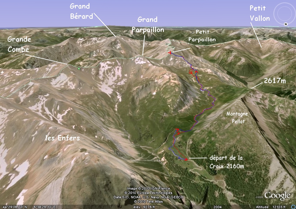
2592x1944 - 1537 ko au sommet (2881m) du Petit Parpaillon, balayage 360° sh ( h : horaire, t : trigo ), en partant du Grand

IMG_2055.JPG
2592x1944 - 1474 ko là on a la cote 2903m en suivant la crête ( 4 randonneurs s'y sont rendus ) et la Grande Combe à sa droite

IMG_2056.JPG
2592x1944 - 1273 ko au centre : la Tête de Vallon Claous et au fond on a pensé au Brec de Chambeyron ( pile poil : cap 74° aligné avec la Tête de l'Infernet )

IMG_2057.JPG
2592x1944 - 1248 ko

IMG_2058.JPG
2592x1944 - 1173 ko en bas la vallée de l'Ubaye ( St Paul )

IMG_2059.JPG
2592x1944 - 1218 ko

IMG_2060.JPG
2592x1944 - 1277 ko on a reconnu Côte Belle ( en contrebas, au centre gauche ) avec les Têtes de Cuguret et Siguret à sa gauche, et à droite vers nous : Pointe fine vers Jausiers

IMG_2061.JPG
2592x1944 - 1402 ko

IMG_2062.JPG
2592x1944 - 1482 ko

IMG_2063.JPG
2592x1944 - 1460 ko le Grand Bérard au centre arrière

IMG_2064.JPG
2592x1944 - 1508 ko une mouche a du se poser sur l'objectif ! ou le frôler de près ( macro ratée ! )

IMG_2065.JPG
2592x1944 - 1723 ko

IMG_2066.JPG
2592x1944 - 1674 ko La Grande Epervière au centre gauche ??? au bout de la crête du Parpaillon et après la Tête de Maralouches

IMG_2067.JPG
2592x1944 - 1602 ko

IMG_2068.JPG
2592x1944 - 1521 ko

IMG_2069.JPG
2592x1944 - 1385 ko

IMG_2070.JPG
2592x1944 - 1338 ko l'Aupillon au centre, au fond

IMG_2072.JPG
2592x1944 - 1273 ko

IMG_2073.JPG
2592x1944 - 1270 ko le Pouzenc au centre g au fond

IMG_2074.JPG
2592x1944 - 1301 ko le Boussolenc au centre

IMG_2075.JPG
2592x1944 - 1408 ko

IMG_2076.JPG
2592x1944 - 1554 ko

IMG_2077.JPG
2592x1944 - 1618 ko le Mont Guillaume au fond, au centre

IMG_2078.JPG
2592x1944 - 1642 ko

IMG_2079.JPG
2592x1944 - 1675 ko

IMG_2080.JPG
2592x1944 - 1630 ko le Mont Tailland à droite de notre sommet

IMG_2081.JPG
2592x1944 - 1717 ko

IMG_2082.JPG
2592x1944 - 1815 ko

IMG_2083.JPG
2592x1944 - 1757 ko

IMG_2084.JPG
2592x1944 - 1547 ko fin du 360° sh

IMG_2085.JPG
2592x1944 - 1246 ko au flanc droit de La Chalance ?

IMG_2086.JPG
2592x1944 - 1546 ko la sortie du tunnel

IMG_2087.JPG
2592x1944 - 792 ko le bout sud du Laverq

IMG_2088.JPG
2592x1944 - 1157 ko avec la Grande Séolane au centre droit

IMG_2089.JPG
2592x1944 - 1197 ko

IMG_2090.JPG
2592x1944 - 1674 ko la Combe des Sonnailes d'après la carte ...

IMG_2091.JPG
2592x1944 - 1838 ko

IMG_2092.JPG
2592x1944 - 2006 ko et notre gardienne de sacs qui patiente ...

IMG_2093.JPG
2592x1944 - 622 ko ça c'était au sud, je crois ( un cap sur la photo ça existe ??? )

IMG_2094.JPG
2592x1944 - 612 ko ?

IMG_2095.JPG
2592x1944 - 510 ko ?

IMG_2096.JPG
2592x1944 - 1005 ko à gauche du Pouzenc --->

IMG_2097.JPG
2592x1944 - 1013 ko et lui-même ! à droite

IMG_2098.JPG
2592x1944 - 866 ko là, à gauche de la Tête de Vallon Claous, je "joue" : au fond : Aiguilles de Chambeyron ? mais plus surement l'ensemble à gauche encore : Mortice et Font Sancte

IMG_2099.JPG
2592x1944 - 971 ko zoom sur le Brec de Chambeyron, au fond, centre droit

IMG_2100.JPG
2592x1944 - 786 ko zoom sur Cuguret à droite et la Bonnette au fond, à flanc gauche

IMG_2101.JPG
2592x1944 - 1326 ko

IMG_2102.JPG
2592x1944 - 1301 ko

IMG_2103.JPG
2592x1944 - 1485 ko

IMG_2104.JPG
2592x1944 - 1314 ko

IMG_2107.JPG
2592x1944 - 1526 ko

IMG_2108.JPG
2592x1944 - 1141 ko re-benoîte rampante

IMG_2109.JPG
2592x1944 - 1582 ko

IMG_2110_descente.JPG
2592x1944 - 1208 ko et Renoncule des Glaciers, je crois, en redescendant

IMG_2111.JPG
2592x1944 - 1622 ko

IMG_2112_sieste.JPG
2592x1944 - 1503 ko photos après la sieste à 2580m, dernier balayage sh

IMG_2113.JPG
2592x1944 - 1467 ko

IMG_2114.JPG
2592x1944 - 1310 ko

IMG_2115.JPG
2592x1944 - 1328 ko

IMG_2116.JPG
2592x1944 - 1362 ko

IMG_2117.JPG
2592x1944 - 1343 ko

IMG_2118.JPG
2592x1944 - 1348 ko notre sommet

IMG_2119.JPG
2592x1944 - 1482 ko

IMG_2120.JPG
2592x1944 - 1534 ko maison !!!
