
IMG_3891_08h03.jpg
2592x1944 - 1217 ko vu que ce sont les męmes sommets qui reviennent ( par rapport au Col du Talon et ŕ Gimette ) je vais essayer de ne pas ętre trop "redondant"

IMG_3892.jpg
2592x1944 - 1500 ko

IMG_3893.jpg
2592x1944 - 1407 ko

IMG_3894.jpg
2592x1944 - 1361 ko on aura les Trois Evęchés en permanence

IMG_3895_08h22.jpg
2592x1944 - 1176 ko

IMG_3896.jpg
2592x1944 - 1012 ko

IMG_3897.jpg
2592x1944 - 845 ko

IMG_3898.jpg
2592x1944 - 670 ko

IMG_3899.jpg
2592x1944 - 737 ko

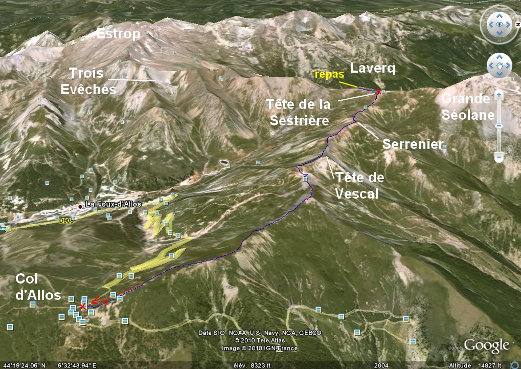
IMG_3900_08h34.jpg
2592x1944 - 1500 ko la Tęte de Vescal apparaît

IMG_3901.jpg
2592x1944 - 1341 ko

IMG_3902.jpg
2592x1944 - 1232 ko

IMG_3903.jpg
2592x1944 - 1263 ko

IMG_3904.jpg
2592x1944 - 1279 ko

IMG_3905.jpg
2592x1944 - 1238 ko

IMG_3906.jpg
2592x1944 - 1264 ko l'observatoire, blanc, et les Evęchés

IMG_3907.jpg
2592x1944 - 1282 ko

IMG_3908.jpg
2592x1944 - 1327 ko

IMG_3909.jpg
2592x1944 - 1331 ko

IMG_3910.jpg
2592x1944 - 1443 ko

IMG_3911.jpg
2592x1944 - 1530 ko

IMG_3912.jpg
2592x1944 - 1646 ko

IMG_3913.jpg
2592x1944 - 1657 ko

IMG_3914.jpg
2592x1944 - 1757 ko

IMG_3915.jpg
2592x1944 - 1675 ko

IMG_3916.jpg
2592x1944 - 1717 ko

IMG_3917.jpg
2592x1944 - 1781 ko

IMG_3918.jpg
2592x1944 - 1861 ko

IMG_3919.jpg
2592x1944 - 1696 ko

IMG_3920.jpg
2592x1944 - 1706 ko l'Aiguille ( d'Allos, en fait elles sont 2 )
en blanc, ŕ droite des Aiguilles, l'Observatoire

IMG_3921.jpg
2592x1944 - 1520 ko la Foux d'Allos

IMG_3922.jpg
2592x1944 - 1211 ko

IMG_3923_08h38.jpg
2592x1944 - 1142 ko le Col des Thuiles

IMG_3924.jpg
2592x1944 - 1437 ko et la Gde Séolane

IMG_3925.jpg
2592x1944 - 1455 ko

IMG_3926.jpg
2592x1944 - 1193 ko

IMG_3927.jpg
2592x1944 - 1305 ko

IMG_3928.jpg
2592x1944 - 1339 ko

IMG_3929.jpg
2592x1944 - 1179 ko

IMG_3930.jpg
2592x1944 - 1021 ko

IMG_3931.jpg
2592x1944 - 1090 ko le sommet que j'ai appelé Gimette 2502 ŕ droite

IMG_3932.jpg
2592x1944 - 1054 ko le dos du Pouzenc

IMG_3933.jpg
2592x1944 - 1127 ko le Péguéiou

IMG_3934.jpg
2592x1944 - 1051 ko

IMG_3935.jpg
2592x1944 - 1056 ko

IMG_3936.jpg
2592x1944 - 830 ko

IMG_3937.jpg
2592x1944 - 825 ko

IMG_3938.jpg
2592x1944 - 874 ko

IMG_3939.jpg
2592x1944 - 833 ko

IMG_3940.jpg
2592x1944 - 776 ko

IMG_3941.jpg
2592x1944 - 751 ko

IMG_3942_08h55.jpg
2592x1944 - 1251 ko lŕ on voit mieux l'Observatoire, blanc ŕ g
puis, les Trois Evęchés, la Dent ... la Petite Barre et la Gde Barre au fond ? et le Sommet Sud ( d'aprčs la carte ! dur dur ! )

IMG_3943_09h09.jpg
2592x1944 - 1131 ko l'Olan au fond

IMG_3944.jpg
2592x1944 - 1255 ko

IMG_3945.jpg
2592x1944 - 1424 ko

IMG_3946.jpg
2592x1944 - 1453 ko

IMG_3947.jpg
2592x1944 - 1091 ko

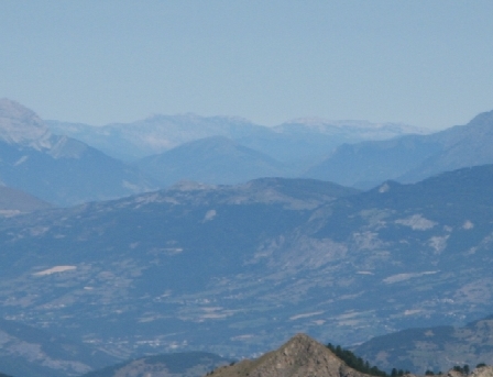
IMG_3948.jpg
2592x1944 - 763 ko le spectre du Viso

IMG_3949.jpg
2592x1944 - 747 ko la Tęte de Moďse derričre la Tęte de Fer ?

IMG_3950.jpg
2592x1944 - 961 ko

IMG_3951_09h52.jpg
2592x1944 - 1786 ko

IMG_3952.jpg
2592x1944 - 1828 ko

IMG_3953_10h20.jpg
2592x1944 - 1611 ko le but en vue, plein centre

IMG_3954.jpg
2592x1944 - 1371 ko

IMG_3955.jpg
2592x1944 - 1099 ko Roche-Close ŕ l'arričre au centre

IMG_3956_10h25.jpg
2592x1944 - 1711 ko la Foux d'Allos

IMG_3957.jpg
2592x1944 - 1815 ko

IMG_3958.jpg
2592x1944 - 1325 ko Roche Cline

IMG_3959.jpg
2592x1944 - 1112 ko

IMG_3960.jpg
2592x1944 - 1058 ko Autapie, Gros Tapi, Valcibičre etc ?

IMG_3961.jpg
2592x1944 - 1236 ko je me demande si le gros lŕ que j'appelle Rougnouse depuis les tables d'orientation de Pra-Loup ne serait pas plutôt le Caduc ? car derričre Valdemars

IMG_3962.jpg
2592x1944 - 1364 ko Rougnouse étant plus bas doit ętre noyé lŕ-dedans au centre

IMG_3963.jpg
2592x1944 - 1527 ko on voit bien les 2 Aiguilles, au centre g
ŕ droite : Auriac ? et derričre ? Tęte Noire ?

IMG_3964.jpg
2592x1944 - 1354 ko Trois Evęchés derričre la Dent des 3Ev.

IMG_3965.jpg
2592x1944 - 1415 ko et lŕ Sommet Sud ŕ d vers nous ?

IMG_3966.jpg
2592x1944 - 1483 ko la Cręte des Courtiens ! drôle de nom

IMG_3967.jpg
2592x1944 - 1478 ko

IMG_3968.jpg
2592x1944 - 1374 ko

IMG_3969.jpg
2592x1944 - 1211 ko

IMG_3970.jpg
2592x1944 - 1255 ko

IMG_3971.jpg
2592x1944 - 1453 ko

IMG_3972_10h51_but en vue.jpg
2592x1944 - 1557 ko la troupe en marche

IMG_3973.jpg
2592x1944 - 1595 ko la Grande Barre ? centre g

IMG_3974_10h54.jpg
2592x1944 - 1234 ko entre Grande Epervičre et Gd Bérard : Pointe Jean Rostand ?

IMG_3975.jpg
2592x1944 - 1021 ko

IMG_3976.jpg
2592x1944 - 912 ko la Meyna au centre

IMG_3977.jpg
2592x1944 - 988 ko l'Aiguille du Chambeyron et le Brec

IMG_3978.jpg
2592x1944 - 920 ko le Bec de l'Aigle, la Tęte de Moďse et la Tęte de fer

IMG_3979.jpg
2592x1944 - 943 ko

IMG_3980.jpg
2592x1944 - 854 ko

IMG_3981.jpg
2592x1944 - 914 ko le Tęton, les 2 chevaux de Bois et le Pelat

IMG_3982.jpg
2592x1944 - 860 ko les Tours du Lac, centre d

IMG_3983.jpg
2592x1944 - 855 ko Roche Cline ŕ d ŕ priori

IMG_3984.jpg
2592x1944 - 819 ko si j'ai bien vu, ici il y aurait de g ŕ d : la Pelonničre de la Frema, la Dent de Ličvre, la Frema (+gde) et la montagne de Noncičre [ je ne sais oů sont passées les Pelens ! ]

IMG_3985.jpg
2592x1944 - 1088 ko

IMG_3986.jpg
2592x1944 - 1291 ko

IMG_3987.jpg
2592x1944 - 1452 ko

IMG_3988_10h57.jpg
2592x1944 - 1415 ko

IMG_3989.jpg
2592x1944 - 1412 ko

IMG_3990.jpg
2592x1944 - 1403 ko

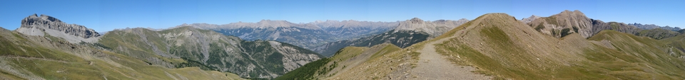
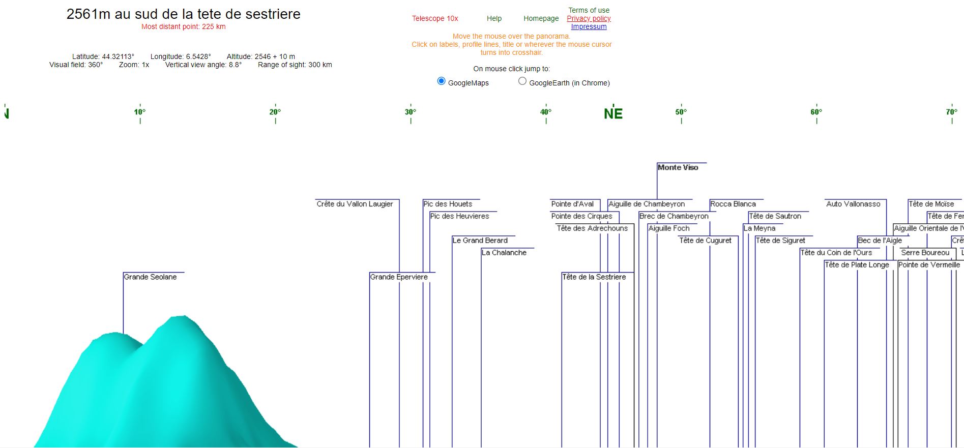
IMG_3991_11h00_tete sestriere.jpg
2592x1944 - 1319 ko Panorama st depuis la Tęte

IMG_3992.jpg
2592x1944 - 1216 ko

IMG_3993.jpg
2592x1944 - 1162 ko

IMG_3994.jpg
2592x1944 - 1149 ko

IMG_3995.jpg
2592x1944 - 1161 ko

IMG_3996.jpg
2592x1944 - 1139 ko

IMG_3997.jpg
2592x1944 - 1224 ko

IMG_3998.jpg
2592x1944 - 1297 ko

IMG_3999.jpg
2592x1944 - 1315 ko

IMG_4000.jpg
2592x1944 - 1302 ko

IMG_4001.jpg
2592x1944 - 1335 ko

IMG_4002.jpg
2592x1944 - 1448 ko

IMG_4003.jpg
2592x1944 - 1537 ko

IMG_4004.jpg
2592x1944 - 1573 ko

IMG_4005.jpg
2592x1944 - 1553 ko

IMG_4006.jpg
2592x1944 - 1622 ko

IMG_4007.jpg
2592x1944 - 1586 ko

IMG_4008.jpg
2592x1944 - 1628 ko

IMG_4009.jpg
2592x1944 - 1654 ko

IMG_4010.jpg
2592x1944 - 1708 ko

IMG_4011.jpg
2592x1944 - 1637 ko

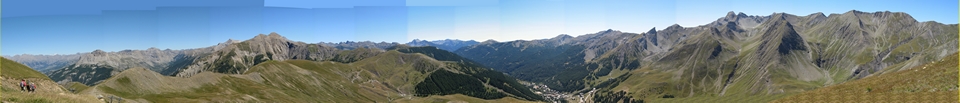
IMG_4012.jpg
2592x1944 - 1548 ko fin du pano st

IMG_4013.jpg
2592x1944 - 1056 ko Neillčre au centre, Dubonas ŕ d

IMG_4014.jpg
2592x1944 - 1046 ko Garnesier et Bure

IMG_4015.jpg
2592x1944 - 970 ko Gd Ferrand et Obiou

IMG_4016.jpg
2592x1944 - 1083 ko les 3 Becs au fond

IMG_4017.jpg
2592x1944 - 970 ko

IMG_4018.jpg
2592x1944 - 1012 ko

IMG_4019.jpg
2592x1944 - 1485 ko l'intérieur du Laverq

IMG_4020.jpg
2592x1944 - 1490 ko

IMG_4021.jpg
2592x1944 - 1563 ko de g ŕ d : Roche Close, le Dos de Chameau et l'Aiguille

IMG_4022.jpg
2592x1944 - 1689 ko

IMG_4023.jpg
2592x1944 - 1702 ko au premier plan : l'Aupillon du Laverq

IMG_4024.jpg
2592x1944 - 962 ko le Vieux Chaillol n'a plus gučre de neige

IMG_4025.jpg
2592x1944 - 868 ko du Vercors, au centre, peut-ętre le Col de l'Arc
en zoomant un peu

IMG_4026_11h34_pendant repas.jpg
2592x1944 - 1379 ko

IMG_4027.jpg
2592x1944 - 1438 ko le lac scintille pendant le repas