
IMG_5518_1ere rampe.JPG
2592x1944 - 1308 ko je ne nommerai les sommets qu'au panorama du sommet car ce sont les męmes vues ŕ peu prčs (-> IMG 5599 )

IMG_5519.JPG
2592x1944 - 1021 ko

IMG_5520.JPG
2592x1944 - 1014 ko

IMG_5521.JPG
2592x1944 - 821 ko

IMG_5522.JPG
2592x1944 - 878 ko

IMG_5523.JPG
2592x1944 - 818 ko

IMG_5524.JPG
2592x1944 - 731 ko

IMG_5525.JPG
2592x1944 - 1244 ko

IMG_5526.JPG
2592x1944 - 985 ko

IMG_5527.JPG
2592x1944 - 989 ko

IMG_5528.JPG
2592x1944 - 1895 ko

IMG_5529.JPG
2592x1944 - 807 ko

IMG_5530.JPG
2592x1944 - 831 ko

IMG_5531.JPG
2592x1944 - 926 ko

IMG_5532.JPG
2592x1944 - 826 ko

IMG_5533.JPG
2592x1944 - 860 ko

IMG_5534.JPG
2592x1944 - 883 ko

IMG_5535.JPG
2592x1944 - 916 ko

IMG_5536.JPG
2592x1944 - 913 ko

IMG_5537.JPG
2592x1944 - 931 ko

IMG_5538.JPG
2592x1944 - 976 ko

IMG_5539.JPG
2592x1944 - 1071 ko

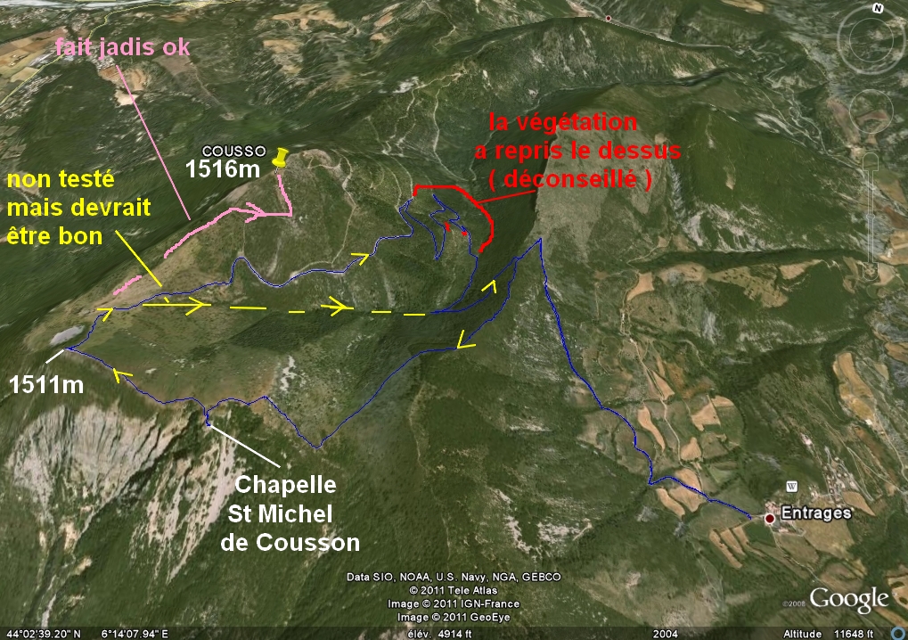
IMG_5540_entrages.JPG
2592x1944 - 1219 ko Entrages notre parking ( excellent et qui a été agrandi, merci ŕ cette petite commune, on se sent accueillis, ce n'est pas comme dans certains endroits ! )

IMG_5541cucuyon & couard.JPG
2592x1944 - 822 ko

IMG_5542_1511m.JPG
2592x1944 - 1646 ko notre sommet ŕ droite ( 1511m )

IMG_5543.JPG
2592x1944 - 1574 ko

IMG_5544_1516m.JPG
2592x1944 - 1468 ko le vrai sommet ( 1516m ) ŕ g. ( que nous avions fait l'autre fois dans la foulée )

IMG_5545_what.JPG
2592x1944 - 780 ko

IMG_5546_vers monges.JPG
2592x1944 - 1380 ko

IMG_5547.JPG
2592x1944 - 1254 ko

IMG_5548.JPG
2592x1944 - 1291 ko

IMG_5549.JPG
2592x1944 - 1580 ko

IMG_5550_plateau chapelle.JPG
2592x1944 - 782 ko on arrive ŕ ce que l'on peut appeler le plateau de la Chapelle ( vers 1475m ) : un petit tour, des fois que ça se bouche !

IMG_5551.JPG
2592x1944 - 806 ko

IMG_5552.JPG
2592x1944 - 760 ko

IMG_5553.JPG
2592x1944 - 790 ko

IMG_5554.JPG
2592x1944 - 744 ko

IMG_5555.JPG
2592x1944 - 777 ko

IMG_5556.JPG
2592x1944 - 1071 ko

IMG_5557.JPG
2592x1944 - 825 ko

IMG_5558.JPG
2592x1944 - 870 ko

IMG_5559.JPG
2592x1944 - 1034 ko

IMG_5560.JPG
2592x1944 - 1012 ko

IMG_5561.JPG
2592x1944 - 1103 ko

IMG_5562.JPG
2592x1944 - 1115 ko

IMG_5563.JPG
2592x1944 - 1088 ko

IMG_5564.JPG
2592x1944 - 1047 ko

IMG_5565.JPG
2592x1944 - 1105 ko

IMG_5566.JPG
2592x1944 - 1346 ko

IMG_5567.JPG
2592x1944 - 1097 ko

IMG_5568.JPG
2592x1944 - 1214 ko

IMG_5569.JPG
2592x1944 - 1194 ko

IMG_5570.JPG
2592x1944 - 894 ko

IMG_5571.JPG
2592x1944 - 875 ko Lure

IMG_5572.JPG
2592x1944 - 969 ko

IMG_5573.JPG
2592x1944 - 1062 ko 1511m au bout lŕ-bas !

IMG_5574.JPG
2592x1944 - 962 ko

IMG_5575.JPG
2592x1944 - 856 ko

IMG_5576.JPG
2592x1944 - 789 ko

IMG_5577.JPG
2592x1944 - 1354 ko la Chapelle de dos, comme on peut la voir en s'approchant du bord

IMG_5578.JPG
2592x1944 - 1659 ko sur son piton

IMG_5579.JPG
2592x1944 - 1220 ko Mézel en bas et l'Asse

IMG_5580_chapelle.JPG
2592x1944 - 1078 ko on y est, de face !

IMG_5584.JPG
2592x1944 - 1512 ko

IMG_5585.JPG
2592x1944 - 1321 ko

IMG_5586.JPG
2592x1944 - 1443 ko

IMG_5587.JPG
2592x1944 - 1341 ko

IMG_5588.JPG
2592x1944 - 1275 ko vers la Gourrée

IMG_5590_~15 chamois.JPG
2592x1944 - 1653 ko en arrivant au sommet sud ( 1511m ) nous avons vu environ 15 chamois au pied ouest

IMG_5591.JPG
2592x1944 - 1087 ko

IMG_5592.JPG
2592x1944 - 1014 ko

IMG_5593.JPG
2592x1944 - 1055 ko

IMG_5594.JPG
2592x1944 - 858 ko

IMG_5595.JPG
2592x1944 - 799 ko ils sont un peu cabots, on a eu le temps de les admirer !

IMG_5596_avant repas _de digne a montdenier.JPG
2592x1944 - 1312 ko Digne calme

IMG_5597_digne.JPG
2592x1944 - 1277 ko ŕ l'Ouest, beaucoup de brume mais on a pu reconnaitre Beaumont, Maraysse, Duffre, Bonnet Rouge, Aujour

IMG_5598.JPG
2592x1944 - 1343 ko et la Bléone paisible

IMG_5599_pano.JPG
2592x1944 - 943 ko la cloche de Barles au centre, Oratoire, Nibles et Cimette ŕ sa gauche

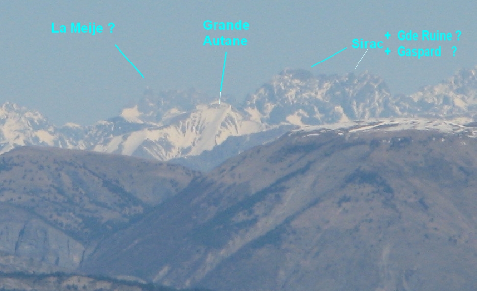
IMG_5600.JPG
2592x1944 - 953 ko sans aucune certitude mais avec une forte conviction, il semble que ce soit le pic de la Meije qui soit au centre ŕ l'extręme, ŕ flanc gauche de Tęte Grosse ( cap 2° ).
Zoom sur l'original car sur cette imagette !!!

IMG_5601.JPG
2592x1944 - 953 ko les Ecrins ŕ droite, mult fois détaillés

IMG_5602.JPG
2592x1944 - 940 ko

IMG_5603.JPG
2592x1944 - 939 ko

IMG_5604.JPG
2592x1944 - 926 ko ici le triangle au centre, et ŕ droite du Pelvoux, serait la Pointe de la Diablée et non le Mourre-Froid, comme je le pensais lŕ-haut

IMG_5605.JPG
2592x1944 - 951 ko le Mourre-Froid est caché derričre la Pointe de Serre, ici ŕ flanc gauche du Blayeul et derričre Clot de Bouc

IMG_5607.JPG
2592x1944 - 899 ko tiens, je suis reparti de Lure ! changement de focale sans doute ?

IMG_5608.JPG
2592x1944 - 886 ko le Traînon ŕ droite de Durbonnas

IMG_5609.JPG
2592x1944 - 904 ko l'Aiguille et Joučre ( avec Bure de chaque côté )

IMG_5610.JPG
2592x1944 - 958 ko la Bigue au centre

IMG_5611.JPG
2592x1944 - 959 ko Géruen ŕ d. de la Bigue, l'Andran vers nous

IMG_5612.JPG
2592x1944 - 943 ko

IMG_5613.JPG
2592x1944 - 939 ko et les Monges ŕ d.

IMG_5614.JPG
2592x1944 - 907 ko

IMG_5615.JPG
2592x1944 - 901 ko

IMG_5616.JPG
2592x1944 - 871 ko ça ! c'est fait !

IMG_5617.JPG
2592x1944 - 862 ko

IMG_5618.JPG
2592x1944 - 874 ko

IMG_5619.JPG
2592x1944 - 897 ko

IMG_5620.JPG
2592x1944 - 911 ko

IMG_5621.JPG
2592x1944 - 931 ko

IMG_5622.JPG
2592x1944 - 919 ko le Blayeul donc ŕ d.

IMG_5623.JPG
2592x1944 - 999 ko

IMG_5624.JPG
2592x1944 - 1025 ko et la Blanche : Dormillouse Bernardez etc

IMG_5625.JPG
2592x1944 - 912 ko

IMG_5626.JPG
2592x1944 - 860 ko Aiguille, Chameau et Roche Close ŕ d.

IMG_5627.JPG
2592x1944 - 885 ko au 1er plan, au centre, Grisonničre

IMG_5628.JPG
2592x1944 - 922 ko

IMG_5629.JPG
2592x1944 - 921 ko l'Estrop

IMG_5630.JPG
2592x1944 - 916 ko

IMG_5631.JPG
2592x1944 - 907 ko lŕ, vous m'excuserz mais je dis toujours Tęte Noire, Caduc Simance sans trop savoir lequel et lequel !

IMG_5632.JPG
2592x1944 - 896 ko par contre le Carton ŕ mi-plan

IMG_5633.JPG
2592x1944 - 904 ko le "petit" Cucuyon derričre le Couard

IMG_5634.JPG
2592x1944 - 886 ko

IMG_5635.JPG
2592x1944 - 909 ko et le majestueux Cheval Blanc pas mal déplumé ! au-dessus de la Montagne de coupe

IMG_5636.JPG
2592x1944 - 895 ko

IMG_5637.JPG
2592x1944 - 865 ko

IMG_5638.JPG
2592x1944 - 841 ko

IMG_5639.JPG
2592x1944 - 819 ko

IMG_5640.JPG
2592x1944 - 819 ko lŕ-bas, on connait pas, je suppose le coin du Gd et Petit Coyer Fréma etc

IMG_5641.JPG
2592x1944 - 808 ko

IMG_5642.JPG
2592x1944 - 842 ko

IMG_5643.JPG
2592x1944 - 827 ko

IMG_5644.JPG
2592x1944 - 794 ko

IMG_5645.JPG
2592x1944 - 825 ko

IMG_5646.JPG
2592x1944 - 827 ko

IMG_5647.JPG
2592x1944 - 803 ko

IMG_5648.JPG
2592x1944 - 821 ko

IMG_5649.JPG
2592x1944 - 813 ko un grand passage ŕ vide !!!

IMG_5650.JPG
2592x1944 - 782 ko

IMG_5651.JPG
2592x1944 - 743 ko

IMG_5652.JPG
2592x1944 - 729 ko

IMG_5653.JPG
2592x1944 - 736 ko

IMG_5654.JPG
2592x1944 - 726 ko ???

IMG_5655.JPG
2592x1944 - 751 ko

IMG_5656.JPG
2592x1944 - 797 ko

IMG_5657.JPG
2592x1944 - 847 ko

IMG_5658.JPG
2592x1944 - 829 ko ici il devrait y avoir les Pt et Gd Mourre et le Mourre de Chanier ?

IMG_5659.JPG
2592x1944 - 802 ko pour arriver en terrain connu : le Chiran

IMG_5660.JPG
2592x1944 - 756 ko

IMG_5661.JPG
2592x1944 - 777 ko

IMG_5662.JPG
2592x1944 - 776 ko et Montdenier derričre Beynes

IMG_5663.JPG
2592x1944 - 783 ko

IMG_5664_zooms repas.JPG
2592x1944 - 543 ko les Rochers de St Michel qui émergent ? derričre Vaumuse

IMG_5665.JPG
2592x1944 - 513 ko et Gâche

IMG_5666.JPG
2592x1944 - 501 ko Durbonnas zoomée

IMG_5667.JPG
2592x1944 - 532 ko le cul de l'Aiguille ? Cluchette ?

IMG_5668.JPG
2592x1944 - 545 ko Guernesier et Col des Aiguilles

IMG_5669_barles en bas.JPG
2592x1944 - 1388 ko on vient de redescendre tout en bas sur la Grande Traversée des Préalpes, le reste est une formalité !

IMG_5670.JPG
2592x1944 - 1165 ko Barles en alignement

IMG_5671_dernier pano pendant retour.JPG
2592x1944 - 1457 ko on a refranchi l'aręte et entamons le final

IMG_5672.JPG
2592x1944 - 1082 ko

IMG_5673.JPG
2592x1944 - 1067 ko

IMG_5674.JPG
2592x1944 - 1098 ko

IMG_5675.JPG
2592x1944 - 1130 ko le pas de la Faye vers le centre

IMG_5676.JPG
2592x1944 - 1222 ko le Pas de Tartonne ŕ gauche de l'éboulis

IMG_5677.JPG
2592x1944 - 1254 ko

IMG_5678.JPG
2592x1944 - 1292 ko Pas de Labaud doit ętre en face au centre

IMG_5679.JPG
2592x1944 - 1272 ko

IMG_5680.JPG
2592x1944 - 1264 ko

IMG_5681.JPG
2592x1944 - 1262 ko

IMG_5682.JPG
2592x1944 - 1144 ko

IMG_5683.JPG
2592x1944 - 1139 ko

IMG_5684.JPG
2592x1944 - 1073 ko

IMG_5685.JPG
2592x1944 - 989 ko

IMG_5686.JPG
2592x1944 - 989 ko

IMG_5687.JPG
2592x1944 - 1145 ko

IMG_5688_arbre tibetain.JPG
2592x1944 - 885 ko dans le haut d'Entrages

IMG_5689.JPG
2592x1944 - 1602 ko non ce n'est pas Noël ! un arbre "tibčtain"