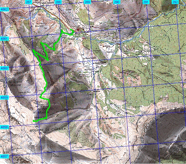
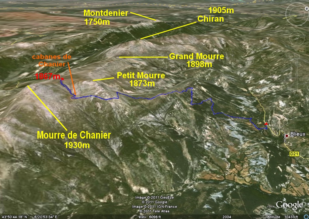
Le Petit Mourre
– ( Mourre de Chanier ) - - - Blieux ( 04 ) -
- - 20/06/11
________ ici
il n'y a que
les imagettes ,
si une ou plusieurs photos vous intéressent en
grand format ,
merci de me faire un mail
Pour
les noms
des sommets ,
on
peut dire qu'ils sont bons
à 90% ,
s'il y a erreur, à vous de corriger, au moins vous avez la
direction
!
Toute remarque constructive pour corriger les plus grosses
erreurs ici sera acceptée par bnbd05@yahoo.fr merci
Retour
Page Liste des Randos
* * * * * *
Attention
: d'abords un rappel
EN MONTAGNE, CHACUN
EST RESPONSABLE DE SA SÉCURITÉ .
Elle requiert également la conscience de ses propres capacités et de
ses limites propres, et implique par conséquent l'acceptation d'un
certain degré de risque.
Par conséquent, les randonnées se font
sous votre propre responsabilité. L'auteur de ce site ne peut pas
garantir l'exactitude ni l'exhaustivité des indications contenues dans
ce site.
Ces renseignements "gratuits" ne peuvent en aucun cas engager la
responsabilité de l'auteur.
* * * * * *
2 autres petits conseils :
que l'on veuille prendre des photos ou juste regarder :
on arrête d'abords
de marcher
dans un passage délicat, comme avec rochers, avec ou sans cables,
quand la marche avant n'est pas aisée ,
la marche
arrière peut être salutaire
* * * * * *
* * * * * *
IMG_6680_a la voiture.jpg
2592x1944 - 3227 ko
IMG_6681.jpg
2592x1944 - 2630 ko
le Chiran vu de la route
IMG_6682.jpg
2592x1944 - 1359 ko
IMG_6683_depart foire.jpg
2592x1944 - 3317 ko une ruine vue
de la route....bouteilles !
IMG_6684_en piste.jpg
2592x1944 - 2303 ko après notre
vaine tentative de rejoindre par des pointillés, nous voilà vraiment en
piste !
IMG_6685.jpg
2592x1944 - 2023 ko un petit coup
d'oeil circulaire --> à partir de Pré-Chauvin ?
IMG_6686.jpg
2592x1944 - 1935 ko
IMG_6687.jpg
2592x1944 - 2361 ko
IMG_6688.jpg
2592x1944 - 2591 ko
IMG_6689.jpg
2592x1944 - 2457 ko
IMG_6690.jpg
2592x1944 - 2984 ko pour nous c'est
la-haut, au fond !
IMG_6691_piste suite.jpg
2592x1944 - 2651 ko minuartie à feuilles de mélèze et pas
céraiste nain !
IMG_6694_piste suite2.jpg
2592x1944 - 2304 ko on a pris un
peu de hauteur, des sommets commencent à émerger
IMG_6695.jpg
2592x1944 - 2224 ko
IMG_6696.jpg
2592x1944 - 2265 ko
IMG_6697.jpg
2592x1944 - 2293 ko
IMG_6698.jpg
2592x1944 - 2367 ko
IMG_6699.jpg
2592x1944 - 2485 ko
IMG_6700.jpg
2592x1944 - 2463 ko
IMG_6701.jpg
2592x1944 - 1847 ko
IMG_6702.jpg
2592x1944 - 1761 ko
IMG_6703.jpg
2592x1944 - 1571 ko
IMG_6704.jpg
2592x1944 - 1460 ko
IMG_6705_piste encore.jpg
2592x1944 - 2011 ko ha ! là, on en
a un peu plus
IMG_6706.jpg
2592x1944 - 2046 ko
IMG_6707.jpg
2592x1944 - 1903 ko
IMG_6708.jpg
2592x1944 - 1939 ko
IMG_6709.jpg
2592x1944 - 1952 ko
IMG_6710.jpg
2592x1944 - 1712 ko
IMG_6711.jpg
2592x1944 - 1584 ko
IMG_6712.jpg
2592x1944 - 1656 ko
IMG_6713_sortie de la piste ouf.jpg
2592x1944 - 2744 ko ce n'est pas
sans soulagement que nous laissons derrière nous cette longue piste
IMG_6714.jpg
2592x1944 - 2832 ko le Petit Mourre
devant nous à g., ce sera finalement notre point de chute final ( au
lieu du Mourre de Chanier )
IMG_6715.jpg
2592x1944 - 2964 ko
IMG_6716.jpg
2592x1944 - 2921 ko
IMG_6717.jpg
2592x1944 - 3073 ko
IMG_6718.jpg
2592x1944 - 3075 ko
IMG_6719.jpg
2592x1944 - 3046 ko et là, le Grand
Mourre près du Chiran, avec ces 2 curieux rochers à son pied ...
IMG_6720.jpg
2592x1944 - 3110 ko
IMG_6721.jpg
2592x1944 - 2897 ko
IMG_6722.jpg
2592x1944 - 3055 ko
IMG_6723.jpg
2592x1944 - 2730 ko et le Chiran
IMG_6724.jpg
2592x1944 - 2850 ko
IMG_6725.jpg
2592x1944 - 2764 ko
IMG_6726.jpg
2592x1944 - 2690 ko
IMG_6727.jpg
2592x1944 - 2189 ko un bout du
Cheval Blanc avec à sa gauche un bout de la Blanche (Aiguille, Dos de
Chameau et Roche Close )
IMG_6728.jpg
2592x1944 - 2014 ko
IMG_6729.jpg
2592x1944 - 2571 ko les curieux
rochers au pied du Gd Mourre
IMG_6730.jpg
2592x1944 - 3385 ko une décharge
publique, merci les écolos !
IMG_6731_arbre salutaire.jpg
2592x1944 - 2504 ko un petit
rafraichissement !
IMG_6732.jpg
2592x1944 - 2370 ko vers le nord-est
IMG_6733.jpg
2592x1944 - 2458 ko
IMG_6734.jpg
2592x1944 - 2431 ko
IMG_6735.jpg
2592x1944 - 2416 ko le GCouard et
le Cucuyon au centre d.
IMG_6736.jpg
2592x1944 - 2329 ko
IMG_6737.jpg
2592x1944 - 2325 ko
IMG_6738.jpg
2592x1944 - 1658 ko vers la Gourre
( Crémon & Bernarde ? )
IMG_6739_a l arete.jpg
2592x1944 - 2886 ko un petit
panorama sens horaire avant de basculer vers les cabanes de
Chanier -->
IMG_6740.jpg
2592x1944 - 2676 ko il parait qu'il
y a la cabane des porcs par là ! quel joli nom !
IMG_6741.jpg
2592x1944 - 2527 ko
IMG_6742.jpg
2592x1944 - 2520 ko
IMG_6743.jpg
2592x1944 - 2527 ko
IMG_6744.jpg
2592x1944 - 2543 ko on part du Roc
et Pic de Garnesier et Bure
IMG_6745.jpg
2592x1944 - 2354 ko on a vu le
Pelvoux à un moment ...
IMG_6746.jpg
2592x1944 - 2469 ko blayeul et
Couard à g.
IMG_6747.jpg
2592x1944 - 2415 ko
IMG_6748.jpg
2592x1944 - 2353 ko trop de monde
inconnu !!!
IMG_6749.jpg
2592x1944 - 2346 ko
IMG_6750.jpg
2592x1944 - 2326 ko
IMG_6751.jpg
2592x1944 - 2392 ko
IMG_6752.jpg
2592x1944 - 2411 ko
IMG_6754.jpg
2592x1944 - 1873 ko la Bernarde ?
IMG_6755.jpg
2592x1944 - 1787 ko
IMG_6756.jpg
2592x1944 - 1786 ko
IMG_6757.jpg
2592x1944 - 1850 ko
IMG_6758.jpg
2592x1944 - 1960 ko
IMG_6759.jpg
2592x1944 - 2051 ko
IMG_6760.jpg
2592x1944 - 2124 ko
IMG_6761.jpg
2592x1944 - 2186 ko
IMG_6762.jpg
2592x1944 - 2155 ko
IMG_6763.jpg
2592x1944 - 2152 ko
IMG_6764.jpg
2592x1944 - 2245 ko le Pelvoux est
dans le lot de nuages
IMG_6765.jpg
2592x1944 - 2167 ko
IMG_6766.jpg
2592x1944 - 2198 ko
IMG_6767.jpg
2592x1944 - 2121 ko
IMG_6768.jpg
2592x1944 - 2167 ko
IMG_6769.jpg
2592x1944 - 2180 ko
IMG_6770.jpg
2592x1944 - 2205 ko
IMG_6771.jpg
2592x1944 - 2138 ko
IMG_6772.jpg
2592x1944 - 2125 ko
IMG_6773_aux cabanes du chanier.jpg
2592x1944 - 2421 ko on arrive aux
cabanes dont une seule est en état, les autres sont en ruines
IMG_6774.jpg
2592x1944 - 3072 ko et il reste ça
à monter, j'y vais .......
à reculons ! je suis mort !
IMG_6775.jpg
2592x1944 - 2721 ko le Mourre de
Chanier est là un peu plus haut à gauche
IMG_6776.jpg
2592x1944 - 2994 ko
IMG_6777.jpg
2592x1944 - 2406 ko je retarde
l'échéance en faisant quelques photos ( et reprenant des forces )
IMG_6778.jpg
2592x1944 - 2436 ko
IMG_6779.jpg
2592x1944 - 2225 ko
IMG_6780.jpg
2592x1944 - 2496 ko
IMG_6781.jpg
2592x1944 - 2485 ko
IMG_6782.jpg
2592x1944 - 2146 ko
IMG_6783.jpg
2592x1944 - 2319 ko
IMG_6784_au Petit Mourre.jpg
2592x1944 - 2699 ko j'y suis enfin
( à 1867m ) entre Petit Mourre ( 1873m ) et le Mourre de Chanier (
1930m )
IMG_6785.jpg
2592x1944 - 2501 ko
IMG_6786.jpg
2592x1944 - 2315 ko
IMG_6787.jpg
2592x1944 - 2212 ko
IMG_6788.jpg
2592x1944 - 2155 ko
IMG_6789.jpg
2592x1944 - 2152 ko le lac de Ste
Croix
IMG_6790.jpg
2592x1944 - 2283 ko
IMG_6791.jpg
2592x1944 - 2352 ko
IMG_6792.jpg
2592x1944 - 2382 ko
IMG_6793.jpg
2592x1944 - 2511 ko le Pavillon au
plan central
IMG_6794.jpg
2592x1944 - 2521 ko
IMG_6795.jpg
2592x1944 - 2429 ko
IMG_6796.jpg
2592x1944 - 2483 ko en plus foncé
la fin sud du Montdenier
IMG_6797.jpg
2592x1944 - 2636 ko
IMG_6798.jpg
2592x1944 - 2626 ko
IMG_6799.jpg
2592x1944 - 2554 ko le Chiran à g.
et le Gd Mourre à sa d.
IMG_6800.jpg
2592x1944 - 2619 ko
IMG_6801.jpg
2592x1944 - 2602 ko
IMG_6802.jpg
2592x1944 - 2594 ko
IMG_6803.jpg
2592x1944 - 2738 ko
IMG_6804.jpg
2592x1944 - 2154 ko
IMG_6805.jpg
2592x1944 - 2216 ko
IMG_6808.jpg
2592x1944 - 2515 ko le Ventoux
déplumé au fond
IMG_6809.jpg
2592x1944 - 2678 ko
IMG_6810.jpg
2592x1944 - 2621 ko
IMG_6811_apres repas.jpg
2592x1944 - 1916 ko
IMG_6812.jpg
2592x1944 - 1912 ko
IMG_6813.jpg
2592x1944 - 1864 ko
IMG_6814.jpg
2592x1944 - 1750 ko
IMG_6815.jpg
2592x1944 - 1709 ko
IMG_6816.jpg
2592x1944 - 1911 ko
IMG_6817.jpg
2592x1944 - 1814 ko
IMG_6818.jpg
2592x1944 - 2022 ko
IMG_6820_flore.jpg
2592x1944 - 2189 ko
IMG_6821.jpg
2592x1944 - 2624 ko
IMG_6822.jpg
2592x1944 - 2766 ko
IMG_6823_avant descente.jpg
3072x2304 - 3804 ko
IMG_6824.jpg
3072x2304 - 3932 ko
IMG_6825.jpg
3072x2304 - 3580 ko
IMG_6826.jpg
3072x2304 - 3226 ko
IMG_6827.jpg
3072x2304 - 2529 ko un truc
reconnaissable pour qui connait au fond au centre
IMG_6828.jpg
3072x2304 - 2653 ko
IMG_6829.jpg
3072x2304 - 2901 ko
IMG_6830.jpg
3072x2304 - 2986 ko
IMG_6831.jpg
3072x2304 - 3495 ko
IMG_6832.jpg
3072x2304 - 3392 ko
IMG_6833.jpg
3072x2304 - 3211 ko
IMG_6834.jpg
3072x2304 - 2952 ko
IMG_6835.jpg
3072x2304 - 2706 ko on a vu des
sommets du Mercantour, mais lesquels ??? et là ça se bouche en plus !
IMG_6836.jpg
3072x2304 - 2672 ko
IMG_6837.jpg
3072x2304 - 2716 ko
IMG_6838.jpg
3072x2304 - 2660 ko
IMG_6839.jpg
3072x2304 - 2667 ko
IMG_6840.jpg
3072x2304 - 2934 ko
IMG_6841.jpg
3072x2304 - 3166 ko
IMG_6842.jpg
3072x2304 - 2852 ko peut-être le
Chambeyron au tiers d.
IMG_6843.jpg
3072x2304 - 2640 ko
IMG_6844.jpg
3072x2304 - 2706 ko
IMG_6845.jpg
3072x2304 - 2803 ko
IMG_6846.jpg
3072x2304 - 2881 ko
IMG_6847.jpg
3072x2304 - 2796 ko
IMG_6848.jpg
3072x2304 - 2805 ko
IMG_6849.jpg
3072x2304 - 2770 ko
IMG_6850.jpg
3072x2304 - 2869 ko
IMG_6851.jpg
3072x2304 - 2815 ko
IMG_6852.jpg
3072x2304 - 2804 ko
IMG_6854.jpg
3072x2304 - 3196 ko
IMG_6855_redescente aux cabanes.jpg
2592x1944 - 1765 ko
IMG_6858.jpg
2592x1944 - 1906 ko
IMG_6859.jpg
2592x1944 - 3540 ko "la" cabane du
Chanier
IMG_6860.jpg
2592x1944 - 3616 ko
IMG_6861.jpg
2592x1944 - 3322 ko aux ruines des
cabanes
IMG_6862.jpg
2592x1944 - 1428 ko bouillon blanc
ou pas ?
IMG_6863.jpg
1944x2592 - 2591 ko volet d'époque
IMG_6864.jpg
2592x1944 - 3174 ko et "berger" en
plein boulot !
IMG_6865-retour plateau.jpg
2592x1944 - 2624 ko adieu au Petit
Mourre
IMG_6866.jpg
2592x1944 - 2453 ko
IMG_6867.jpg
2592x1944 - 2345 ko
IMG_6868.jpg
2592x1944 - 3004 ko
IMG_6869_on va repister.jpg
2592x1944 - 2237 ko
IMG_6870.jpg
2592x1944 - 2224 ko il était bien
beau
IMG_6871.jpg
2592x1944 - 2431 ko
IMG_6872_retour voiture.jpg
2592x1944 - 2636 ko
IMG_6873.jpg
2592x1944 - 1845 ko et en zoomant
on s'y croirait encore !
Page générée le 20/06/2011
website tracker widget