Plancol – Col d'Ornon - - - Chantelouve  (38) - - - 17/08/11

________ici il n'y a que les imagettes, si une ou plusieurs photos vous intéressent en grand format,

merci de me faire un mail

            Pour les noms des sommets,

on peut dire qu'ils sont bons à 90%, s'il y a erreur, à vous de corriger, au moins vous avez la direction !

Toute remarque constructive pour corriger les plus grosses erreurs ici sera acceptée par      bnbd05@yahoo.fr    merci


                                                                                   Retour Page Liste des Randos

* * * * * *

Attention   :    d'abords un rappel

EN MONTAGNE, CHACUN EST RESPONSABLE DE SA SÉCURITÉ. Elle requiert également la conscience de ses propres capacités et de ses limites propres, et implique par conséquent l'acceptation d'un certain degré de risque.

Par conséquent, les randonnées se font sous votre propre responsabilité. L'auteur de ce site ne peut pas garantir l'exactitude ni l'exhaustivité des indications contenues dans ce site.
Ces renseignements "gratuits" ne peuvent en aucun cas engager la responsabilité de l'auteur.

* * * * * *

            2 autres petits conseils :

     que l'on veuille prendre des photos ou juste regarder   :
                                                      on arrête   d'abords   de marcher


dans un passage délicat, comme avec rochers, avec ou sans cables,

quand la marche avant n'est pas aisée, la marche arrière peut être salutaire

* * * * * *


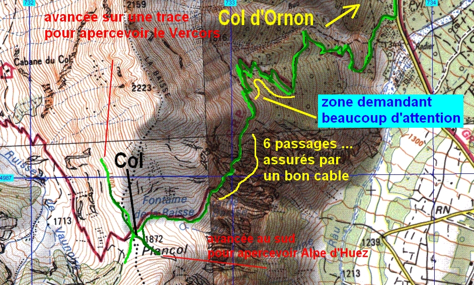
   notes :          

   6 passages au moins assurés par un bon cable  !

pas pour personnes sujettes au vertige ni aux enfants en bas âge

mais il faut faire encore plus attention aux zigs-zags plus bas où un chemin très étroit passe dans une végétation importante et où on peut mettre facilement le pied à côté ou bien où ça peut s'effondrer !!!


* * * * * *


IMG_7649_au parking col.jpg
2592x1944 - 1685 ko
   belle journée en perspective, au nord


IMG_7650.jpg
2592x1944 - 1439 ko   et au sud


IMG_7651.jpg
2592x1944 - 1608 ko


IMG_7652.jpg
2592x1944 - 1711 ko   le Grand Armet nous attend, en avant !


IMG_7653_premiers clips.jpg
2592x1944 - 2604 ko   la voiture rouge, c'est nous


IMG_7654.jpg
2592x1944 - 1194 ko


IMG_7655.jpg
2592x1944 - 1314 ko


IMG_7656.jpg
2592x1944 - 1220 ko   dans quelle direction ? ça !   il devrait y avoir un compas magnétique intégré dans l'appareil photo ...


IMG_7657.jpg
2592x1944 - 1330 ko


IMG_7658.jpg
2592x1944 - 1346 ko   donc ce serait Faraut et le Pic Pierroux qui émergent du Col d'Hurtières à droite du Gargas


IMG_7659_oeillets de montpellier.JPG
2592x1944 - 3107 ko


IMG_7660.jpg
2592x1944 - 1526 ko


IMG_7661_pas raisins d ours_busserole.JPG
2592x1944 - 2536 ko


IMG_7662.jpg
2592x1944 - 2005 ko


IMG_7663_gentiane de pannoni---.JPG
2592x1944 - 3101 ko


IMG_7664.jpg
1944x2592 - 1421 ko


IMG_7665.jpg
2592x1944 - 1771 ko


IMG_7666.jpg
2592x1944 - 1736 ko


IMG_7667.jpg
2592x1944 - 1485 ko


IMG_7668_euphraise commune_casse lunettes.JPG
1944x2592 - 1546 ko


IMG_7669.jpg
2592x1944 - 1667 ko


IMG_7670.jpg
1944x2592 - 1706 ko


IMG_7671_orpin des infideles.JPG
1944x2592 - 2142 ko


IMG_7672.jpg
2592x1944 - 1618 ko


IMG_7673_centauree uniflore_au casse croute.JPG
1944x2592 - 1941 ko


IMG_7674.jpg
2592x1944 - 2153 ko


IMG_7675.jpg
2592x1944 - 2136 ko


IMG_7676_autre petiote---.jpg
1944x2592 - 2858 ko


IMG_7677.jpg
2592x1944 - 1537 ko


IMG_7678_chantelouve.jpg
2592x1944 - 2935 ko


IMG_7679.jpg
2592x1944 - 2925 ko


IMG_7680.jpg
2592x1944 - 2785 ko


IMG_7681.jpg
2592x1944 - 2419 ko


IMG_7682.jpg
2592x1944 - 2663 ko


IMG_7683.jpg
2592x1944 - 2264 ko


IMG_7684.jpg
2592x1944 - 2253 ko   la voiture de rallye vient de "mugir" ( avant les passages de gués !!! )


IMG_7685.jpg
2592x1944 - 1467 ko   vers le Lac du Vallon dans la pénombre


IMG_7686.jpg
2592x1944 - 2491 ko   au sud...


IMG_7687.jpg
2592x1944 - 1674 ko   les 2 même avec le Pic de Bure en plus à droite


IMG_7688.jpg
2592x1944 - 910 ko


IMG_7689.jpg
2592x1944 - 885 ko   et 3 paraboles de l'Observatoire à droite du bâtiment


IMG_7692_grande mauve---.jpg
1944x2592 - 1961 ko


IMG_7693.jpg
2592x1944 - 1834 ko


IMG_7694.jpg
1944x2592 - 1896 ko


IMG_7696.jpg
2592x1944 - 2026 ko


IMG_7697_aconit anti thora_pas la "tue loup".jpg
1944x2592 - 2066 ko


IMG_7698.jpg
1944x2592 - 1430 ko


IMG_7699.jpg
1944x2592 - 1805 ko


IMG_7700_joubarbe des toits.jpg
2592x1944 - 3289 ko


IMG_7701.jpg
2592x1944 - 3275 ko   c'est la première fois que nous voyons un "monstre pareil" !


IMG_7702.jpg
2592x1944 - 2776 ko   en plein sur le chemin, dommage, tôt ou tard elle va être cassée


IMG_7703.jpg
2592x1944 - 2935 ko   l'index de JP pour l'échelle de grandeur


IMG_7704_vers alpe d huez.jpg
2592x1944 - 3130 ko


IMG_7705.jpg
2592x1944 - 1609 ko   les Grandes Rousses que l'on verra mieux après manger


IMG_7706_on arrive bientot.jpg
2592x1944 - 2449 ko


IMG_7707.jpg
2592x1944 - 2503 ko   le Grand Armet ( entier ? )


IMG_7708.jpg
2592x1944 - 2683 ko


IMG_7709.jpg
2592x1944 - 3032 ko   vers le col lui-même


IMG_7710.jpg
2592x1944 - 2358 ko


IMG_7711.jpg
2592x1944 - 2140 ko


IMG_7712.jpg
2592x1944 - 1463 ko   là, sans détailler ce serait le flanc nord du vallon de Valjouffrey avec l'Arcanier etc, un coin inconnu pour nous


IMG_7713.jpg
2592x1944 - 1597 ko


IMG_7714.jpg
2592x1944 - 3108 ko   je détaille "la Baisse", au nord   ||-->


IMG_7715.jpg
2592x1944 - 3159 ko


IMG_7716.jpg
2592x1944 - 2923 ko


IMG_7717.jpg
2592x1944 - 2986 ko


IMG_7718.jpg
2592x1944 - 2714 ko   -->||


IMG_7719.jpg
2592x1944 - 2712 ko   JP est aspiré par le Col !


IMG_7720.jpg
2592x1944 - 1639 ko   et toujours le coin du Rochail, en face qui nous rappelle la magnifique balade du Lac du Vallon


IMG_7721.jpg
1944x2592 - 1745 ko


IMG_7722.jpg
2592x1944 - 2223 ko


IMG_7723.jpg
2592x1944 - 1708 ko


IMG_7724.jpg
2592x1944 - 1633 ko


IMG_7725.jpg
2592x1944 - 1484 ko


IMG_7726.jpg
2592x1944 - 1448 ko


IMG_7727.jpg
2592x1944 - 1683 ko


IMG_7728.jpg
2592x1944 - 1548 ko   de g. à d., le Petit et Grand Renaud et le Pic du Col d'Ornon ..., à gauche du col du Rochail


IMG_7729.jpg
2592x1944 - 1661 ko


IMG_7730_au poteau du col.jpg
2592x1944 - 2676 ko   en face, au nord-est, le Petit et le Grand Taillefer


IMG_7731.jpg
2592x1944 - 2557 ko


IMG_7732.jpg
2592x1944 - 2512 ko   et les Mayes entre les Taillefer et la Baisse, mais nous les verrons mieux tout-à-l'heure


IMG_7733.jpg
2592x1944 - 2325 ko


IMG_7734.jpg
2592x1944 - 2339 ko


IMG_7735.jpg
2592x1944 - 2309 ko


IMG_7736.jpg
2592x1944 - 2382 ko


IMG_7737.jpg
2592x1944 - 2169 ko


IMG_7738.jpg
2592x1944 - 2148 ko


IMG_7739.jpg
2592x1944 - 2366 ko


IMG_7740.jpg
2592x1944 - 2380 ko


IMG_7741.jpg
2592x1944 - 3139 ko   JP m'attend pour une photo de flore ...


IMG_7742.jpg
2592x1944 - 2374 ko


IMG_7743.jpg
2592x1944 - 2438 ko


IMG_7744.jpg
2592x1944 - 2743 ko


IMG_7745.jpg
2592x1944 - 2675 ko


IMG_7746.jpg
2592x1944 - 2739 ko   au centre, le Col de Combe Oursière entre la Grisonnière ( 2736m ) .... et ...


IMG_7747.jpg
2592x1944 - 2494 ko   et un sans nom ( 2458m )


IMG_7748.jpg
2592x1944 - 2536 ko


IMG_7749.jpg
2592x1944 - 3088 ko


IMG_7750.jpg
1944x2592 - 3145 ko


IMG_7751_benoite des montagnes.jpg
2592x1944 - 3401 ko


IMG_7753.jpg
2592x1944 - 1862 ko


IMG_7754.jpg
2592x1944 - 2300 ko


IMG_7755_vers lac vallon.jpg
1944x2592 - 1987 ko


IMG_7759_on s avance au max.jpg
2592x1944 - 2795 ko   on avance sur une trace ou draye pour voir à l'horizon entre les deux ... ( deux randonneurs ont été aperçus en bas sur le GR qui vient au Col


IMG_7760.jpg
2592x1944 - 2392 ko


IMG_7761.jpg
2592x1944 - 2806 ko


IMG_7762.jpg
2592x1944 - 2790 ko


IMG_7763.jpg
2592x1944 - 3238 ko   2 belles cascades, des névés, et bouts de glaciers


IMG_7764.jpg
2592x1944 - 2090 ko   vercors : l'axe donnerait entre Pic St Michel et Moucherotte mais difficile à préciser davantage !


IMG_7765.jpg
2592x1944 - 2447 ko   voici les Mayes en mieux, j'ai oublié de photographier les moutons ...


IMG_7766.jpg
2592x1944 - 2161 ko   Clot Beaumont ?


IMG_7767.jpg
2592x1944 - 1754 ko


IMG_7768_au repas.jpg
2592x1944 - 2882 ko


IMG_7769.jpg
2592x1944 - 2886 ko


IMG_7770.jpg
2592x1944 - 2430 ko


IMG_7771.jpg
2592x1944 - 1254 ko   le glacier au pied nord du Gd Armet


IMG_7772.jpg
2592x1944 - 1543 ko


IMG_7773.jpg
2592x1944 - 2761 ko   pendant le repas, à l'ombre d'un arbre, c'est rafraîchissant ces névés et glaciers


IMG_7774.jpg
2592x1944 - 2919 ko


IMG_7777_apres repas.jpg
2592x1944 - 2099 ko   à cette heure, le Rochail est bien éclairé, avec à sa d. la Pointe de Malhaubert et la Pointe de Confolant, vers nous la Berche Noire


IMG_7778.jpg
2592x1944 - 1888 ko


IMG_7779.jpg
2592x1944 - 1894 ko


IMG_7780.jpg
2592x1944 - 2071 ko


IMG_7781.jpg
2592x1944 - 1321 ko


IMG_7782.jpg
2592x1944 - 2002 ko   et le sommet des Clottous


IMG_7783.jpg
2592x1944 - 1203 ko   la Tête de Rame ?


IMG_7784_cherche cabane de la vache.jpg
2592x1944 - 1395 ko


IMG_7785.jpg
2592x1944 - 1066 ko   la cabane doit être là à gauche, au dessus des zigs-zags, "le truc sombre" ?


IMG_7786_on avance au max au sud_1880m.jpg
2592x1944 - 2696 ko


IMG_7787.jpg
2592x1944 - 2066 ko
   les Grandes Rousses au-dessus d'Alpe d'Huez avec le Pic du Lac Blanc, Le Pic de la pyramide, le Pic Bayle ...  voit-on jusqu'au Pic de l'Etendard ?


IMG_7788.jpg
2592x1944 - 2049 ko   Alpe d'Huez dans le trou,   à d. de Prégentil ?


IMG_7789.jpg
2592x1944 - 1870 ko


IMG_7790_a la sieste sous bouleau.jpg
3072x2304 - 1850 ko   le Rochail au centre


IMG_7791.jpg
3072x2304 - 1794 ko   le beau caillou à d.


IMG_7792.jpg
3072x2304 - 1731 ko   la Pointe de Malhaubert


IMG_7793.jpg
3072x2304 - 1683 ko   et la Pointe de Confolant


IMG_7794.jpg
3072x2304 - 1582 ko   le Lac du Vallon est là, encaissé, s'il ne s'est pas évaporé !


IMG_7795.jpg
3072x2304 - 3185 ko


IMG_7796.jpg
3072x2304 - 3238 ko   la Cabane du Pré de la Vache devrait être plein centre mais est très dure à voir !


IMG_7801_la geante au retour.jpg
2592x1944 - 2488 ko   "bonsoir Madame" !


IMG_7802_ou sont alles les autres.jpg
2592x1944 - 2730 ko   quelques randonneurs nous ont quitté le matin pour partir dans cette pente herbeuse mais pour aller où ???
vers la borne 2361m ? ou le clot Beaumont 2447m ?


IMG_7803.jpg
2592x1944 - 2899 ko


IMG_7804.jpg
2592x1944 - 2848 ko


IMG_7805.jpg
2592x1944 - 2079 ko   vers le Pic de Belledonne ?


IMG_7806.jpg
2592x1944 - 1821 ko


IMG_7807.jpg
2592x1944 - 1657 ko   et le Rissiou à g. ( ce n'est qu'une hypothèse ) mais ça me parait important


IMG_7808.jpg
2592x1944 - 966 ko


IMG_7809.jpg
2592x1944 - 1109 ko


IMG_7810.jpg
2592x1944 - 1003 ko   en bas dans la vallée au nord


IMG_7811_busserole.jpg
2592x1944 - 3509 ko


IMG_7812.jpg
2592x1944 - 2075 ko   non ce ne sont pas des myrtilles mais on en a mangé là-haut, et des framboises en montant ce matin


IMG_7813_a la route.jpg
2592x1944 - 2657 ko   à 100m de la voiture, un dernier coup d'oeil vers la Baisse


IMG_7814.jpg
2592x1944 - 1653 ko


IMG_7815.jpg
2592x1944 - 1501 ko   et le Gd Armet


Retour

* * * * * *

Retour Page Liste

Page générée le 19/08/2011