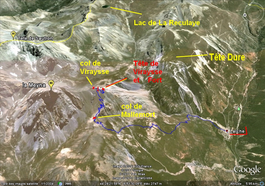
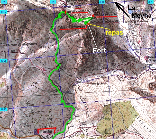
Tête de Viraysse      – Larche    (04)     - - -    16/09/11

________ici il n'y a que les imagettes, si une ou plusieurs photos vous intéressent en grand format,

merci de me faire un mail

            Pour les noms des sommets,

on peut dire qu'ils sont bons à 90%, s'il y a erreur, à vous de corriger, au moins vous avez la direction !

Toute remarque constructive pour corriger les plus grosses erreurs ici sera acceptée par      bnbd05@yahoo.fr    merci


                                                                                   Retour Page Liste des Randos

* * * * * *

Attention   :    d'abords un rappel

EN MONTAGNE, CHACUN EST RESPONSABLE DE SA SÉCURITÉ. Elle requiert également la conscience de ses propres capacités et de ses limites propres, et implique par conséquent l'acceptation d'un certain degré de risque.

Par conséquent, les randonnées se font sous votre propre responsabilité. L'auteur de ce site ne peut pas garantir l'exactitude ni l'exhaustivité des indications contenues dans ce site.
Ces renseignements "gratuits" ne peuvent en aucun cas engager la responsabilité de l'auteur.

* * * * * *

            2 autres petits conseils :

     que l'on veuille prendre des photos ou juste regarder   :
                                                      on arrête   d'abords   de marcher


dans un passage délicat, comme avec rochers, avec ou sans cables,

quand la marche avant n'est pas aisée, la marche arrière peut être salutaire

* * * * * *

* * * * * *


* * * * * *


IMG_8354_peu apres depart_piste.JPG
2592x1944 - 1542 ko
   au sud


IMG_8355.JPG
2592x1944 - 1543 ko


IMG_8356.JPG
2592x1944 - 1952 ko


IMG_8357.JPG
2592x1944 - 2091 ko   le mille-feuilles de l'autre jour ?


IMG_8358.JPG
2592x1944 - 1723 ko
   au nord


IMG_8359.JPG
2592x1944 - 1884 ko


IMG_8360_flore.JPG
2592x1944 - 2019 ko


IMG_8361.JPG
2592x1944 - 1984 ko


IMG_8362_premiers raidillons_1819m.JPG
2592x1944 - 2314 ko
   des demoiselles décoiffées et un peu "plates"


IMG_8363_2026m.JPG
2592x1944 - 1219 ko
   vers le nord-est


IMG_8364.JPG
2592x1944 - 1717 ko


IMG_8365.JPG
2592x1944 - 1055 ko


IMG_8366.JPG
2592x1944 - 799 ko
   du sud-est --->


IMG_8367.JPG
2592x1944 - 832 ko


IMG_8368.JPG
2592x1944 - 942 ko


IMG_8369.JPG
2592x1944 - 1087 ko


IMG_8370.JPG
2592x1944 - 1290 ko


IMG_8371.JPG
2592x1944 - 1321 ko


IMG_8372.JPG
2592x1944 - 1326 ko


IMG_8373.JPG
2592x1944 - 1335 ko


IMG_8374.JPG
2592x1944 - 1306 ko


IMG_8375.JPG
2592x1944 - 1121 ko
   --->   au sud-ouest


IMG_8376.JPG
2592x1944 - 1372 ko
   le col de Mallemort dans l'axe à d.


IMG_8377_casse croute_2170m.JPG
2592x1944 - 1319 ko
   la Tête de Moïse ?


IMG_8378.JPG
2592x1944 - 1460 ko


IMG_8379.JPG
2592x1944 - 1432 ko
   vers le col de Larche


IMG_8380.JPG
2592x1944 - 1702 ko
   vers le Lauzannier


IMG_8381.JPG
2592x1944 - 1063 ko
   pour la cabane au col


IMG_8382.JPG
2592x1944 - 1500 ko


IMG_8383.JPG
2592x1944 - 1185 ko
   est-ce le dos rond du Gd Bérard qui se montre derrière ?


IMG_8384.JPG
2592x1944 - 2077 ko
   là-haut ...


IMG_8385.JPG
2592x1944 - 1519 ko
   le fort de la Tête de Viraysse, notre but


IMG_8386_larche_2220m.JPG
2592x1944 - 2608 ko
   Larche


IMG_8387_plateau_2270m.JPG
2592x1944 - 2841 ko


IMG_8388.JPG
2592x1944 - 2492 ko


IMG_8389_bergers_2325m.JPG
2592x1944 - 2762 ko
   le berger surveille plus la bergère ( allongée ) que les moutons ...


IMG_8390.JPG
2592x1944 - 3195 ko


IMG_8391.JPG
2592x1944 - 3071 ko


IMG_8392.JPG
2592x1944 - 2836 ko


IMG_8393_2418m.JPG
2592x1944 - 2941 ko
   le spécialiste en cairns à l'ouvrage


IMG_8394.JPG
2592x1944 - 2543 ko


IMG_8395.JPG
2592x1944 - 2373 ko


IMG_8396_jeunette_2443m.JPG
2592x1944 - 1427 ko
   bonjour jeune fille !


IMG_8397_col mallemort_2555m.JPG
2592x1944 - 3344 ko
   j'arrive au col de Mallemort, baraquements de Viraysse en face


IMG_8398.JPG
2592x1944 - 2329 ko   la Tête des Bréquets à g. ( 1er des Rochers de St ours vers nous )


IMG_8399.JPG
2592x1944 - 2417 ko


IMG_8400.JPG
2592x1944 - 2191 ko


IMG_8401.JPG
2592x1944 - 2432 ko


IMG_8402.JPG
2592x1944 - 2101 ko
   et la bien jolie "Meyna" qui serait bien plus jolie si elle ne nous cachait pas le Brec de Chambeyron


IMG_8403.JPG
2592x1944 - 3045 ko
   et pendant ce temps là .............


IMG_8404.JPG
2592x1944 - 2309 ko
   vers le col de Viraysse


IMG_8405.JPG
2592x1944 - 1880 ko
   et le fort ensoleillé


IMG_8406.JPG
2592x1944 - 2817 ko
   à d. à flanc, la trace qui nous aurait mené à Roir Alp


IMG_8407.JPG
2592x1944 - 2082 ko
   le col sans nom ( un de plus )


IMG_8409_premiers lacets_2580m.JPG
2592x1944 - 1932 ko
   et là on pense à La mortice au fond


IMG_8410.JPG
2592x1944 - 1971 ko
   vers le Panestrel et La Font-Sancte


IMG_8411_trou vers 2590m.JPG
2592x1944 - 2992 ko
   curiosité allant avec le fort sans doute


IMG_8412.JPG
2592x1944 - 2327 ko


IMG_8413.JPG
2592x1944 - 2555 ko
   Roir Alp à d. ( peut-être aurait-on vu le Brec de là-bas ?


IMG_8414.JPG
2592x1944 - 1945 ko


IMG_8415_montee_2610m.JPG
2592x1944 - 2821 ko


IMG_8416.JPG
2592x1944 - 2608 ko


IMG_8417.JPG
2592x1944 - 2281 ko
   la Tête des Bréquets nous cache la Tête de la Courbe ( culminant des Rochers de St Ours )


IMG_8418.JPG
2592x1944 - 2235 ko


IMG_8419.JPG
2592x1944 - 2348 ko


IMG_8420.JPG
2592x1944 - 2460 ko


IMG_8421.JPG
2592x1944 - 2275 ko


IMG_8422.JPG
2592x1944 - 2762 ko


IMG_8423.JPG
2592x1944 - 2809 ko
   le chemin est long mais d'excellente qualité


IMG_8424.JPG
2592x1944 - 2698 ko
   l'estafette en haut


IMG_8425_surplomb_2638m.JPG
2592x1944 - 1983 ko
   me voici où JP était juste avant, vue sud


IMG_8426.JPG
2592x1944 - 2099 ko


IMG_8427.JPG
2592x1944 - 2304 ko


IMG_8428.JPG
2592x1944 - 2511 ko
   à l'ouest


IMG_8429.JPG
2592x1944 - 2168 ko


IMG_8430.JPG
2592x1944 - 1579 ko


IMG_8431.JPG
2592x1944 - 1578 ko


IMG_8432.JPG
2592x1944 - 1522 ko


IMG_8433.JPG
2592x1944 - 1437 ko


IMG_8434.JPG
2592x1944 - 1621 ko


IMG_8435.JPG
2592x1944 - 1909 ko


IMG_8436.JPG
2592x1944 - 1814 ko


IMG_8437.JPG
2592x1944 - 2178 ko


IMG_8438.JPG
2592x1944 - 2301 ko
   le Pelvoux au nord-ouest


IMG_8439.JPG
2592x1944 - 1030 ko


IMG_8440_pres du col_2685m.JPG
2592x1944 - 2232 ko


IMG_8441.JPG
2592x1944 - 2374 ko
   la Tête de Sautron émerge au nord-est


IMG_8442.JPG
2592x1944 - 2319 ko


IMG_8443.JPG
2592x1944 - 2218 ko


IMG_8444.JPG
2592x1944 - 1910 ko


IMG_8445_col de viraysse_2713m.JPG
2592x1944 - 2067 ko
   me voici au col de Viraysse


IMG_8446.JPG
2592x1944 - 1950 ko
   le lac de l'Orrenaye fait coucou


IMG_8447.JPG
2592x1944 - 1676 ko


IMG_8448.JPG
2592x1944 - 1538 ko
   la Tête de Moïse


IMG_8449.JPG
2592x1944 - 1535 ko


IMG_8450.JPG
2592x1944 - 1532 ko


IMG_8451.JPG
2592x1944 - 1686 ko


IMG_8452.JPG
2592x1944 - 2333 ko


IMG_8453.JPG
2592x1944 - 2416 ko
   la Meyna sous un autre angle


IMG_8454.JPG
2592x1944 - 2411 ko
   et le fort de Viraysse


IMG_8455_au fort_2751m.JPG
2592x1944 - 2336 ko
   nous y voici


IMG_8456.JPG
2592x1944 - 2227 ko


IMG_8457.JPG
2592x1944 - 2060 ko


IMG_8458.JPG
2592x1944 - 1997 ko


IMG_8459.JPG
2592x1944 - 2119 ko


IMG_8460.JPG
2592x1944 - 1942 ko


IMG_8461.JPG
2592x1944 - 2185 ko
   on visite peut-être mais sur rendez-vous ?


IMG_8462.JPG
2592x1944 - 2623 ko
   on va manger là à d.


IMG_8463_repas_2760m.JPG
2592x1944 - 1702 ko
   vers le Panestrel ( à g. ? )  et la Font-Sancte


IMG_8464.JPG
2592x1944 - 1265 ko


IMG_8465.JPG
2592x1944 - 1246 ko
   Ailefroide, le Coup de Sabre et le Pelvoux


IMG_8466_vautours.JPG
3072x2304 - 1060 ko
   et les visiteurs


IMG_8468.JPG
3072x2304 - 1073 ko


IMG_8469.JPG
2592x1944 - 1548 ko
   on en a vu 5 à 8 ensemble au maxi


IMG_8470_redemarrage.JPG
2592x1944 - 2279 ko
   on attaque le retour


IMG_8471.JPG
2592x1944 - 2202 ko


IMG_8472.JPG
2592x1944 - 2147 ko
   le lac de la Reculaye est au fond à g. et la Tête Dure herbeuse à d., Moïse au centre


IMG_8473.JPG
2592x1944 - 2275 ko


IMG_8474.JPG
2592x1944 - 2672 ko


IMG_8475.JPG
2592x1944 - 1789 ko
   quelques zooms sur le nord-est et l'est avant de quitter


IMG_8476.JPG
2592x1944 - 1927 ko


IMG_8477.JPG
2592x1944 - 1935 ko


IMG_8478.JPG
2592x1944 - 2018 ko


IMG_8479.JPG
2592x1944 - 1600 ko


IMG_8480.JPG
2592x1944 - 1724 ko


IMG_8481.JPG
2592x1944 - 1505 ko


IMG_8482.JPG
2592x1944 - 1738 ko


IMG_8483.JPG
2592x1944 - 1703 ko


IMG_8484.JPG
2592x1944 - 1712 ko


IMG_8485.JPG
2592x1944 - 1551 ko


IMG_8486.JPG
2592x1944 - 1724 ko


IMG_8487.JPG
2592x1944 - 1954 ko


IMG_8488.JPG
2592x1944 - 1680 ko


IMG_8489.JPG
2592x1944 - 3079 ko
   un lac sec


IMG_8490.JPG
2592x1944 - 2710 ko
   le Sautron


IMG_8491.JPG
2592x1944 - 2440 ko


IMG_8492.JPG
2592x1944 - 2147 ko


IMG_8493.JPG
2592x1944 - 2245 ko


IMG_8494.JPG
2592x1944 - 2396 ko


IMG_8495.JPG
2592x1944 - 2158 ko


IMG_8496_pano_2755m.JPG
2592x1944 - 2635 ko
   le col de Mallemort à nos pieds, au centre


IMG_8497.JPG
2592x1944 - 2741 ko


IMG_8498.JPG
2592x1944 - 2486 ko


IMG_8499.JPG
2592x1944 - 2657 ko
   Larche


IMG_8500.JPG
3072x2304 - 3020 ko
   et un petit pano sens horaire ---> du S E


IMG_8501.JPG
3072x2304 - 2767 ko


IMG_8502.JPG
3072x2304 - 2683 ko


IMG_8503.JPG
3072x2304 - 2656 ko


IMG_8504.JPG
3072x2304 - 2713 ko


IMG_8505.JPG
3072x2304 - 2838 ko


IMG_8506.JPG
3072x2304 - 3005 ko


IMG_8507.JPG
3072x2304 - 3137 ko


IMG_8508.JPG
3072x2304 - 3142 ko


IMG_8509.JPG
3072x2304 - 3103 ko


IMG_8510.JPG
3072x2304 - 3133 ko


IMG_8511.JPG
3072x2304 - 3082 ko


IMG_8512.JPG
3072x2304 - 3117 ko


IMG_8513.JPG
3072x2304 - 3037 ko


IMG_8514.JPG
3072x2304 - 3090 ko


IMG_8515.JPG
3072x2304 - 3100 ko


IMG_8516.JPG
3072x2304 - 3099 ko


IMG_8517.JPG
3072x2304 - 3427 ko


IMG_8518.JPG
3072x2304 - 3283 ko


IMG_8519.JPG
3072x2304 - 3353 ko


IMG_8520.JPG
3072x2304 - 3552 ko


IMG_8521.JPG
3072x2304 - 3371 ko


IMG_8522.JPG
3072x2304 - 3547 ko


IMG_8523.JPG
3072x2304 - 3979 ko


IMG_8524.JPG
3072x2304 - 3549 ko


IMG_8525.JPG
3072x2304 - 3960 ko
   --->  au N E    fin de pano


IMG_8526.JPG
2592x1944 - 1704 ko
   quelques zooms en crête  --->


IMG_8527.JPG
2592x1944 - 2039 ko


IMG_8528.JPG
2592x1944 - 2010 ko


IMG_8529.JPG
2592x1944 - 2016 ko


IMG_8530.JPG
2592x1944 - 2017 ko


IMG_8531.JPG
2592x1944 - 2047 ko


IMG_8532.JPG
2592x1944 - 1971 ko


IMG_8533.JPG
2592x1944 - 1931 ko


IMG_8534.JPG
2592x1944 - 1939 ko


IMG_8535.JPG
2592x1944 - 1876 ko


IMG_8536.JPG
2592x1944 - 2036 ko


IMG_8537.JPG
2592x1944 - 2036 ko


IMG_8538.JPG
2592x1944 - 1666 ko


IMG_8539.JPG
2592x1944 - 1686 ko


IMG_8540.JPG
2592x1944 - 1912 ko
   --->  fin des zooms, on y va


IMG_8541_sous col m_2574m.JPG
2592x1944 - 2476 ko
   on a refranchi le col de Mallemort, pour faire une mini sieste


IMG_8542_apres sieste_2449m.JPG
2592x1944 - 2786 ko
   le départ des moutons nous a réveillé, ça bêlait à qui mieux mieux, voici les 2 retardataires


IMG_8543.JPG
2592x1944 - 1900 ko
   madame et son jeune fils bien chancelant


IMG_8544_descente_2346m.JPG
2592x1944 - 2446 ko
   au N O


IMG_8545.JPG
2592x1944 - 2466 ko


IMG_8546_fort la croix a meyronnes_2332m.JPG
2592x1944 - 2236 ko
   le fort La Croix au-dessus de Meyronnes


IMG_8547.JPG
2592x1944 - 1411 ko


IMG_8548_moutons ont migre_2277m.JPG
2592x1944 - 2414 ko
   et les moutons qui nous avaient quitté


IMG_8549.JPG
2592x1944 - 1239 ko


IMG_8550.JPG
2592x1944 - 1261 ko

            499 ......... 500 ............. 501

                      j'arrête de compter !     faut rentrer !

Retour

* * * * * *

Retour Page Liste

Page générée le 17/09/2011