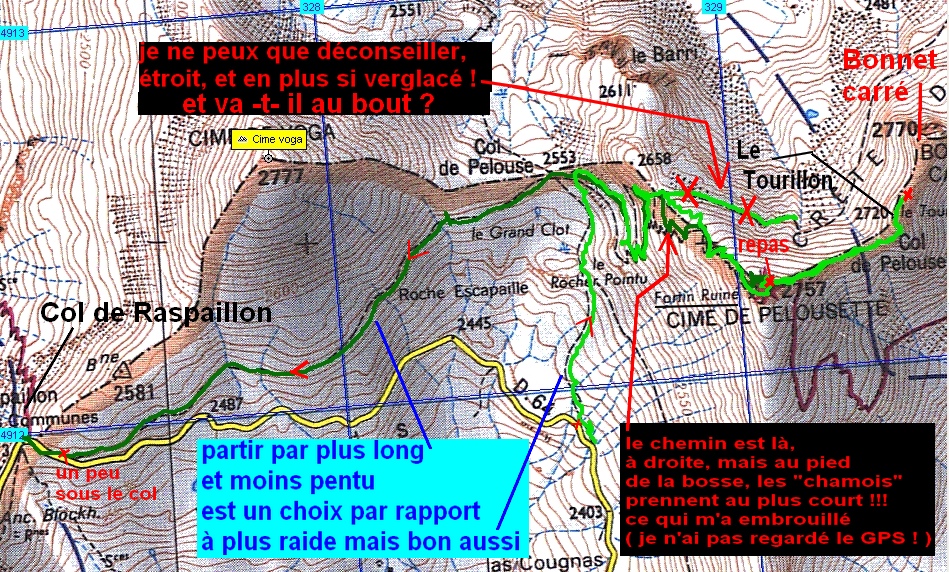
Cime de Pelousette - - - Col de Raspaillon  (04) - - - 21/09/11

________ici il n'y a que les imagettes, si une ou plusieurs photos vous intéressent en grand format,

merci de me faire un mail

            Pour les noms des sommets,

on peut dire qu'ils sont bons à 90%, s'il y a erreur, à vous de corriger, au moins vous avez la direction !

Toute remarque constructive pour corriger les plus grosses erreurs ici sera acceptée par      bnbd05@yahoo.fr    merci


                                                                                   Retour Page Liste des Randos

* * * * * *

Attention   :    d'abords un rappel

EN MONTAGNE, CHACUN EST RESPONSABLE DE SA SÉCURITÉ. Elle requiert également la conscience de ses propres capacités et de ses limites propres, et implique par conséquent l'acceptation d'un certain degré de risque.

Par conséquent, les randonnées se font sous votre propre responsabilité. L'auteur de ce site ne peut pas garantir l'exactitude ni l'exhaustivité des indications contenues dans ce site.
Ces renseignements "gratuits" ne peuvent en aucun cas engager la responsabilité de l'auteur.

* * * * * *

            2 autres petits conseils :

     que l'on veuille prendre des photos ou juste regarder   :
                                                      on arrête   d'abords   de marcher


dans un passage délicat, comme avec rochers, avec ou sans cables,

quand la marche avant n'est pas aisée, la marche arrière peut être salutaire

* * * * * *


            le chemin vers le col par le pied du pan sud de la Tour Carrée doit être faisable
                        mais nous ne l'avons pas testé, suite à ma perte de temps par la voie intérieure !

* * * * * *

Conscient que les imagettes étaient vraiment très petites ou plutôt petites, jadis,

vous avez une
page plus "dense", mais sans commentaires, cliquer --> ICI   retour par page préc.


IMG_8554_a la voiture.JPG
2592x1944 - 1838 ko
   à l'ouest


IMG_8555.JPG
2592x1944 - 1826 ko
   jolies couleurs au lever du soleil


IMG_8556.JPG
2592x1944 - 1668 ko


IMG_8557.JPG
2592x1944 - 1739 ko
   le Col de la Bonnette à g.


IMG_8558.JPG
2592x1944 - 1706 ko


IMG_8559_vers rocher pointu 2588.JPG
2592x1944 - 1499 ko
   Cime de Voga à priori


IMG_8560.JPG
2592x1944 - 1573 ko


IMG_8561.JPG
2592x1944 - 1665 ko
   au nord


IMG_8562.JPG
2592x1944 - 1906 ko
   au sud


IMG_8563.JPG
2592x1944 - 1871 ko


IMG_8564.JPG
2592x1944 - 1876 ko


IMG_8565.JPG
2592x1944 - 1800 ko
   au nord


IMG_8566.JPG
2592x1944 - 1625 ko
   le Pelvoux immanquable


IMG_8567.JPG
2592x1944 - 1511 ko


IMG_8568.JPG
2592x1944 - 1419 ko


IMG_8569.JPG
2592x1944 - 1407 ko


IMG_8570.JPG
2592x1944 - 1404 ko


IMG_8571.JPG
2592x1944 - 1768 ko


IMG_8572.JPG
2592x1944 - 1742 ko


IMG_8573.JPG
2592x1944 - 2233 ko


IMG_8574_presque au pied.JPG
2592x1944 - 2064 ko


IMG_8575_a la separation.JPG
2592x1944 - 1836 ko
   le Restefond


IMG_8576.JPG
2592x1944 - 1953 ko
   le Mourre Haut


IMG_8577.JPG
2592x1944 - 2633 ko


IMG_8578.JPG
2592x1944 - 2336 ko


IMG_8579.JPG
2592x1944 - 2231 ko


IMG_8580.JPG
2592x1944 - 1769 ko


IMG_8581.JPG
2592x1944 - 1670 ko


IMG_8582.JPG
2592x1944 - 1754 ko
   le vallon où je suis allé traîné mes guêtres, à tord !


IMG_8583.JPG
2592x1944 - 1692 ko
   la Tour Carrée


IMG_8584.JPG
2592x1944 - 1613 ko


IMG_8585.JPG
2592x1944 - 1382 ko
   et vers le Tourillon


IMG_8586.JPG
2592x1944 - 1310 ko


IMG_8587.JPG
2592x1944 - 1370 ko


IMG_8588.JPG
2592x1944 - 1313 ko


IMG_8589.JPG
2592x1944 - 1428 ko


IMG_8590.JPG
2592x1944 - 2612 ko
   le Lac de Pelouse ou ce qu'il en reste !


IMG_8591.JPG
2592x1944 - 1353 ko


IMG_8592.JPG
2592x1944 - 1368 ko


IMG_8593.JPG
2592x1944 - 1434 ko
   on pense la Mortice à l'arrière g.


IMG_8594_juste avant chamois.JPG
2592x1944 - 2596 ko


IMG_8595_2 chamois de video.JPG
   image tirée de vidéo
640x480 - 167 ko
   2 chamois effrayés par JP en haut et rabattus vers moi sur cette mini trace, ils auraient pu me pousser !


IMG_8596_en route pour pelousette.JPG
1944x2592 - 1721 ko
   je me suis sorti sans encombre du mauvais pas et je grimpe la bosse sans avoir vu le sentier à d.


IMG_8597.JPG
2592x1944 - 2000 ko


IMG_8598.JPG
2592x1944 - 2123 ko


IMG_8599.JPG
2592x1944 - 1860 ko


IMG_8600.JPG
2592x1944 - 1854 ko
   je vais retrouver le sentier dans la pente et le collègue ! peut-être ?


IMG_8601_au fortin ruine.JPG
2592x1944 - 2457 ko
   me voici au "fortin ruiné" de la Cime de Pelousette


IMG_8602.JPG
2592x1944 - 2679 ko


IMG_8603.JPG
2592x1944 - 2684 ko
   nous mangerons sur la terrasse tout-à-l'heure ...


IMG_8604_au casse croute.JPG
2592x1944 - 2360 ko
   le randonneur par l'odeur alléchée est revenu sur ses pas !


IMG_8605.JPG
2592x1944 - 2113 ko
   un homme en extase devant la Tour Carrée et le Tourillon


IMG_8606.JPG
2592x1944 - 2042 ko
   on pose les sacs et on y retourne ensemble !


IMG_8607_arrivee au tourillon.JPG
2592x1944 - 2464 ko


IMG_8608.JPG
2592x1944 - 2335 ko


IMG_8609.JPG
2592x1944 - 2186 ko


IMG_8610.JPG
2592x1944 - 2019 ko


IMG_8611.JPG
2592x1944 - 1973 ko


IMG_8612.JPG
2592x1944 - 1979 ko


IMG_8613.JPG
2592x1944 - 1751 ko
   arrivée au tourillon


IMG_8614_au tourillon.JPG
1944x2592 - 2474 ko
   Hercule dans ses oeuvres !


IMG_8615.JPG
1944x2592 - 2415 ko


IMG_8616.JPG
2592x1944 - 2705 ko
   JP me dit que le chemin passe au pied de la Tour Carrée ..., je veux bien, mais j'ai eu assez de frayeurs pour aujourd'hui !   je le crois sur paroles


IMG_8617.JPG
2592x1944 - 2468 ko


IMG_8618.JPG
2592x1944 - 2569 ko
   trois petits tours et puis s'en va


IMG_8619.JPG
2592x1944 - 2694 ko
   un bout du Lac des Sagnes en haut


IMG_8620.JPG
2592x1944 - 2271 ko


IMG_8621.JPG
2592x1944 - 2477 ko
   l'ombre du tourillon


IMG_8622.JPG
1944x2592 - 2363 ko
   un petit cairn pour garder la main !


IMG_8623.JPG
2592x1944 - 2499 ko


IMG_8624.JPG
2592x1944 - 2180 ko


IMG_8625.JPG
2592x1944 - 1810 ko


IMG_8626.JPG
2592x1944 - 1718 ko


IMG_8627.JPG
2592x1944 - 1628 ko


IMG_8628.JPG
2592x1944 - 1675 ko


IMG_8629.JPG
2592x1944 - 1768 ko


IMG_8631.JPG
2592x1944 - 2458 ko


IMG_8632.JPG
2592x1944 - 2892 ko


IMG_8633.JPG
2592x1944 - 2985 ko


IMG_8634.JPG
2592x1944 - 1547 ko
   vers Argentera


IMG_8635.JPG
2592x1944 - 1744 ko
   direction Auron


IMG_8636.JPG
2592x1944 - 2059 ko


IMG_8637.JPG
2592x1944 - 1536 ko
   Mont Ténibre ?


IMG_8638.JPG
2592x1944 - 1634 ko
   Tête de Moïse ?


IMG_8639.JPG
2592x1944 - 2068 ko


IMG_8640.JPG
2592x1944 - 2287 ko
   Tête Carrée


IMG_8641.JPG
2592x1944 - 2076 ko


IMG_8642.JPG
2592x1944 - 2388 ko


IMG_8643.JPG
2592x1944 - 2738 ko
   on retourne sur nos pas, le fortin là-bas


IMG_8644_retour.JPG
2592x1944 - 2531 ko


IMG_8645.JPG
2592x1944 - 2361 ko
   vallon de Pelouse


IMG_8646_on recupere nos sacs.JPG
2592x1944 - 2940 ko


IMG_8647.JPG
2592x1944 - 2384 ko


IMG_8650_au fortin avant repas.JPG
3072x2304 - 3735 ko
   le Camp des Fourches


IMG_8651.JPG
3072x2304 - 2519 ko
   un petit panorama sens horaire ---> est


IMG_8652.JPG
3072x2304 - 2364 ko


IMG_8653.JPG
3072x2304 - 2537 ko


IMG_8654.JPG
3072x2304 - 2207 ko


IMG_8655.JPG
3072x2304 - 2207 ko


IMG_8656.JPG
3072x2304 - 2307 ko


IMG_8657.JPG
3072x2304 - 2253 ko


IMG_8658.JPG
3072x2304 - 2254 ko


IMG_8659.JPG
3072x2304 - 2124 ko


IMG_8660.JPG
3072x2304 - 2188 ko


IMG_8661.JPG
3072x2304 - 2224 ko


IMG_8662.JPG
3072x2304 - 2211 ko


IMG_8663.JPG
3072x2304 - 2129 ko


IMG_8664.JPG
3072x2304 - 2181 ko
   Auron en bas


IMG_8665.JPG
3072x2304 - 2192 ko
   je pense au Mont Mounier


IMG_8666.JPG
3072x2304 - 2379 ko


IMG_8667.JPG
3072x2304 - 2371 ko
   caractéristique mais inconnu au centre


IMG_8668.JPG
3072x2304 - 2452 ko


IMG_8669.JPG
3072x2304 - 2422 ko


IMG_8670.JPG
3072x2304 - 2602 ko


IMG_8671.JPG
3072x2304 - 2761 ko


IMG_8672.JPG
3072x2304 - 2661 ko


IMG_8673.JPG
3072x2304 - 2631 ko
   dans le coin il y a le Mont Vinaigre mais je ne sais lequel c'est ( le Pointu là-bas ? )


IMG_8674.JPG
3072x2304 - 2662 ko


IMG_8675.JPG
3072x2304 - 3044 ko


IMG_8676.JPG
3072x2304 - 3001 ko
   vers Gialorgues ?


IMG_8677.JPG
3072x2304 - 3167 ko


IMG_8678.JPG
3072x2304 - 3104 ko


IMG_8679.JPG
3072x2304 - 3118 ko


IMG_8680.JPG
3072x2304 - 2862 ko


IMG_8681.JPG
3072x2304 - 3244 ko


IMG_8682.JPG
3072x2304 - 3162 ko


IMG_8683.JPG
3072x2304 - 3159 ko


IMG_8684.JPG
3072x2304 - 2970 ko


IMG_8685.JPG
3072x2304 - 3004 ko
   le Mont Pelat


IMG_8686.JPG
3072x2304 - 2789 ko
   la Bonnette


IMG_8687.JPG
3072x2304 - 2781 ko
   le Cimet


IMG_8688.JPG
3072x2304 - 2837 ko


IMG_8689.JPG
3072x2304 - 2543 ko


IMG_8690.JPG
3072x2304 - 2821 ko
   axe Caire Brun, Chevalier, Ventebrun etc


IMG_8691.JPG
3072x2304 - 2869 ko
   le Restefond


IMG_8692.JPG
3072x2304 - 2832 ko
   la Gde Séolane


IMG_8693.JPG
3072x2304 - 2907 ko


IMG_8694.JPG
3072x2304 - 3085 ko


IMG_8695.JPG
3072x2304 - 2867 ko
   Cime de Voga


IMG_8696.JPG
3072x2304 - 3277 ko
   le Mourre Haut


IMG_8697.JPG
3072x2304 - 2780 ko


IMG_8698.JPG
3072x2304 - 2869 ko


IMG_8699.JPG
3072x2304 - 2858 ko
   vers le Gd Bérard ?


IMG_8700.JPG
3072x2304 - 2546 ko


IMG_8701.JPG
3072x2304 - 2474 ko


IMG_8702.JPG
3072x2304 - 2426 ko


IMG_8703.JPG
3072x2304 - 2509 ko
   Coste belle au centre vers nous


IMG_8704.JPG
3072x2304 - 2545 ko
   Cuguret à d. du pelvoux


IMG_8705.JPG
3072x2304 - 2626 ko
   et Siguret


IMG_8706.JPG
3072x2304 - 2804 ko


IMG_8707.JPG
3072x2304 - 2720 ko
   la Tête du Coin de l'Ours je crois à g.


IMG_8708.JPG
3072x2304 - 2705 ko
   Mortice au fond


IMG_8709.JPG
3072x2304 - 2795 ko


IMG_8710.JPG
3072x2304 - 2902 ko


IMG_8711.JPG
3072x2304 - 3009 ko
   et la Tête de Fer à g. ?


IMG_8712.JPG
3072x2304 - 3001 ko
   vers les Aiguilles du Chambeyron ?


IMG_8713.JPG
3072x2304 - 3080 ko


IMG_8714.JPG
3072x2304 - 3124 ko


IMG_8715.JPG
3072x2304 - 2733 ko


IMG_8716.JPG
3072x2304 - 2880 ko


IMG_8717.JPG
3072x2304 - 2611 ko
   --->   fin du pano


IMG_8718_a la sieste.JPG
2592x1944 - 1966 ko
   un petit tour du propriétaire ...


IMG_8719.JPG
2592x1944 - 1869 ko


IMG_8720.JPG
2592x1944 - 2222 ko
   its time !


IMG_8721.JPG
2592x1944 - 2440 ko


IMG_8722.JPG
2592x1944 - 2517 ko


IMG_8723.JPG
2592x1944 - 2271 ko


IMG_8724.JPG
2592x1944 - 1616 ko


IMG_8725.JPG
2592x1944 - 1760 ko


IMG_8726.JPG
2592x1944 - 1452 ko


IMG_8727.JPG
2592x1944 - 1722 ko


IMG_8728.JPG
2592x1944 - 1612 ko


IMG_8729.JPG
2592x1944 - 1599 ko


IMG_8730.JPG
2592x1944 - 1671 ko


IMG_8731.JPG
2592x1944 - 1666 ko


IMG_8732.JPG
2592x1944 - 1589 ko


IMG_8733.JPG
2592x1944 - 1768 ko


IMG_8734.JPG
2592x1944 - 1712 ko


IMG_8735.JPG
2592x1944 - 2209 ko


IMG_8738_la voiture au redemarrage.JPG
2592x1944 - 2817 ko
   le char rouge nous attend en bas, au centre


IMG_8739.JPG
2592x1944 - 2678 ko
   un petit coup d'oeil avant la descente


IMG_8740.JPG
2592x1944 - 2839 ko


IMG_8741.JPG
2592x1944 - 2629 ko


IMG_8743_vers tete carree.JPG
2592x1944 - 3020 ko
   une trace du genre de celle que j'ai testée


IMG_8744_pendant descente 2599.JPG
2592x1944 - 2607 ko


IMG_8745.JPG
2592x1944 - 2813 ko


IMG_8746_moutons au retour long 2528.JPG
2592x1944 - 3176 ko
   le chauffeur est redescendu à la voiture, il va me reprendre au Col de Raspaillon, je teste l'autre voie "cool"


IMG_8747_casemate a g du col de raspaillon.JPG
2592x1944 - 2846 ko
   j'approche du Col, mon chauffeur y est depuis 10mn et tchache avec les touristes en m'attendant


IMG_8748_vautour bonnette.JPG
2592x1944 - 972 ko
   vautour en vadrouille

            Cette dernière photo n'a pas été prise dans la balade,
mais quelques minutes après, au Col de la Bonnette.


           Nous nous y sommes arrêtés au retour pour prendre
 un panorama de 360° qui est classé à part, en bas dans la liste...


Retour

* * * * * *

Retour Page Liste

Page générée le 21/09/2011