Le Rognon – Les Sièzes - - - Lus La Croix Haute (26) - - - 23/09/11

________ici il n'y a que les imagettes, si une ou plusieurs photos vous intéressent en grand format,

merci de me faire un mail

            Pour les noms des sommets,

on peut dire qu'ils sont bons à 90%, s'il y a erreur, à vous de corriger, au moins vous avez la direction !

Toute remarque constructive pour corriger les plus grosses erreurs ici sera acceptée par      bnbd05@yahoo.fr    merci


                                                                                   Retour Page Liste des Randos

* * * * * *

Attention   :    d'abords un rappel

EN MONTAGNE, CHACUN EST RESPONSABLE DE SA SÉCURITÉ. Elle requiert également la conscience de ses propres capacités et de ses limites propres, et implique par conséquent l'acceptation d'un certain degré de risque.

Par conséquent, les randonnées se font sous votre propre responsabilité. L'auteur de ce site ne peut pas garantir l'exactitude ni l'exhaustivité des indications contenues dans ce site.
Ces renseignements "gratuits" ne peuvent en aucun cas engager la responsabilité de l'auteur.

* * * * * *

            2 autres petits conseils :

     que l'on veuille prendre des photos ou juste regarder   :
                                                      on arrête   d'abords   de marcher


dans un passage délicat, comme avec rochers, avec ou sans cables,

quand la marche avant n'est pas aisée, la marche arrière peut être salutaire

* * * * * *


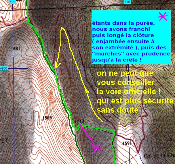
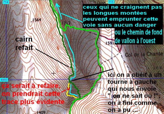
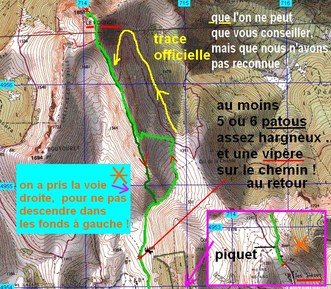
                                                                                                          î
                                                                                   descente   î
     <----- montée

------------------------------------------------------


        Quelle que soit la voie choisie,

     c'est une belle crête

                et un beau sommet !


* * * * * *


IMG_8871_peu apres depart.JPG
2592x1944 - 1479 ko   on s'est quand même risqué, malgré la brume qui est présente dans tout le coin


IMG_8872.JPG
2592x1944 - 1613 ko
   on a espoir que le soleil gagne bientôt


IMG_8873_au casse croute.JPG
2592x1944 - 1630 ko
   vers Toussière c'est déjà gagné


IMG_8874.JPG
2592x1944 - 1913 ko
   on casse la croûte à l'abri d'une carcasse de camionnette car la bise n'est pas chaude du tout !


IMG_8875_arrivee a la crete.JPG
2592x1944 - 1412 ko
   je n'ai pas songé à faire d'autres photos pendant la montée, on était trop occupés par le tracé ...


IMG_8876.JPG
2592x1944 - 1423 ko
   le Jocou derrière


IMG_8877.JPG
2592x1944 - 1452 ko


IMG_8878.JPG
1944x2592 - 1658 ko


IMG_8879_peu apres.JPG
2592x1944 - 1706 ko


IMG_8880.JPG
2592x1944 - 1674 ko
   au sud-ouest c'est bien dégagé


IMG_8881.JPG
2592x1944 - 1667 ko


IMG_8882.JPG
2592x1944 - 1624 ko


IMG_8883.JPG
2592x1944 - 1682 ko


IMG_8884.JPG
2592x1944 - 2110 ko


IMG_8885.JPG
2592x1944 - 2366 ko


IMG_8886_ca se decouvre.JPG
2592x1944 - 1322 ko
   mais à l'est c'est pas encore ça !


IMG_8887.JPG
2592x1944 - 1314 ko


IMG_8888.JPG
2592x1944 - 1315 ko


IMG_8889.JPG
2592x1944 - 1281 ko


IMG_8890.JPG
2592x1944 - 1320 ko


IMG_8891.JPG
2592x1944 - 1293 ko


IMG_8892.JPG
2592x1944 - 1286 ko


IMG_8893.JPG
2592x1944 - 1287 ko
   le Grand Ferrand


IMG_8894.JPG
2592x1944 - 1289 ko


IMG_8895.JPG
2592x1944 - 1319 ko


IMG_8896.JPG
2592x1944 - 1313 ko


IMG_8897.JPG
2592x1944 - 1290 ko
   la Tête de Vachères au centre


IMG_8898.JPG
2592x1944 - 1313 ko
   Pointe Feuillette à g. au premier plan, le Col des Aiguilles derrière, et Garnesier à d.


IMG_8899.JPG
2592x1944 - 1260 ko


IMG_8900.JPG
2592x1944 - 1334 ko


IMG_8901.JPG
2592x1944 - 1700 ko
   dans l'axe de notre crête, la masse sombre de Durbonas


IMG_8902.JPG
2592x1944 - 1277 ko


IMG_8903.JPG
2592x1944 - 1758 ko


IMG_8904.JPG
2592x1944 - 1840 ko


IMG_8905.JPG
2592x1944 - 2154 ko
   le Mont Aiguille et le Gd Veymont émergent


IMG_8906.JPG
2592x1944 - 2138 ko
   et à nous le Rognon !


IMG_8907.JPG
2592x1944 - 1338 ko
   l'Obiou au centre avec la crête du Rattier à sa g.


IMG_8908.JPG
2592x1944 - 1352 ko
   l'Aup


IMG_8909.JPG
2592x1944 - 1548 ko


IMG_8912_y a plus qu a.JPG
2592x1944 - 2265 ko
   le bout de l'arête finale, c'est au fond à gauche comme les ..


IMG_8913.JPG
2592x1944 - 1518 ko


IMG_8914.JPG
2592x1944 - 1415 ko
   le Vercors au centre au fond


IMG_8915.JPG
2592x1944 - 1381 ko
   au premier plan : crête de Jiboui et Mont Barral


IMG_8916.JPG
2592x1944 - 1361 ko


IMG_8917.JPG
2592x1944 - 1338 ko


IMG_8918.JPG
2592x1944 - 1361 ko


IMG_8919.JPG
2592x1944 - 1371 ko


IMG_8920.JPG
2592x1944 - 1365 ko


IMG_8921.JPG
2592x1944 - 1381 ko
   encore un petit effort, pour le soleil !


IMG_8922.JPG
2592x1944 - 1359 ko


IMG_8923.JPG
2592x1944 - 1420 ko


IMG_8924.JPG
2592x1944 - 1713 ko


IMG_8925.JPG
2592x1944 - 2019 ko


IMG_8926.JPG
2592x1944 - 1741 ko


IMG_8927.JPG
2592x1944 - 1505 ko


IMG_8928.JPG
2592x1944 - 1512 ko


IMG_8929.JPG
2592x1944 - 1505 ko


IMG_8930.JPG
2592x1944 - 1548 ko


IMG_8931.JPG
2592x1944 - 1528 ko


IMG_8932.JPG
2592x1944 - 1545 ko


IMG_8933.JPG
2592x1944 - 1527 ko


IMG_8934.JPG
2592x1944 - 1505 ko


IMG_8935.JPG
2592x1944 - 1499 ko
   la Tête Chevalière je pense


IMG_8936.JPG
2592x1944 - 1558 ko


IMG_8937.JPG
2592x1944 - 1616 ko


IMG_8938.JPG
2592x1944 - 1729 ko


IMG_8939.JPG
2592x1944 - 2367 ko


IMG_8940.JPG
2592x1944 - 2385 ko
   le vallon central sud vers le col de la Chante et les Sièzes, des patous charmants nous y ont "acclamés" à l'aller ( les mêmes qui seront en liberté au retour ! )


IMG_8941.JPG
2592x1944 - 2259 ko


IMG_8942.JPG
2592x1944 - 1854 ko


IMG_8943.JPG
2592x1944 - 1492 ko


IMG_8944_aux rochers.JPG
2592x1944 - 2073 ko
   je suis arrivé à d. des rochers


IMG_8945.JPG
2592x1944 - 1658 ko
   au bout du Vercors, le Pic St Michel et le Moucherotte


IMG_8946.JPG
2592x1944 - 1749 ko


IMG_8947.JPG
2592x1944 - 1519 ko
   plein nord : les Monts du Bugey ???


IMG_8948.JPG
2592x1944 - 1498 ko


IMG_8949.JPG
2592x1944 - 1503 ko
   je pense Charmant Som et Chamechaude, en tout cas Chartreuse


IMG_8950.JPG
2592x1944 - 1490 ko
   et là, Dent de Crolles et Cie à Grenoble


IMG_8951.JPG
2592x1944 - 1481 ko


IMG_8952.JPG
2592x1944 - 1544 ko
   le Mont Tabor à St Honoré 1500 à g.


IMG_8953.JPG
2592x1944 - 1536 ko
   les Taillefer


IMG_8954.JPG
2592x1944 - 1517 ko
   les Armets


IMG_8955.JPG
2592x1944 - 2485 ko


IMG_8956.JPG
2592x1944 - 2379 ko


IMG_8957.JPG
2592x1944 - 2676 ko


IMG_8958.JPG
2592x1944 - 2732 ko


IMG_8959.JPG
2592x1944 - 2780 ko


IMG_8960.JPG
2592x1944 - 2587 ko
   ce n'est pas une apparition, c'est JP qui attend le pastis !


IMG_8961.JPG
2592x1944 - 2200 ko


IMG_8962.JPG
2592x1944 - 2408 ko


IMG_8963.JPG
2592x1944 - 1654 ko
   j'arrive !


IMG_8964.JPG
2592x1944 - 2012 ko


IMG_8965_a la croix.JPG
2592x1944 - 2427 ko
   le Boutouret à g., Toussière au fond avec le Quigouret


IMG_8966.JPG
2592x1944 - 2823 ko


IMG_8967.JPG
2592x1944 - 2645 ko
   le Col de Lus en bas


IMG_8968.JPG
1944x2592 - 2821 ko
   vas ist das ? ( petite fenêtre en français )


IMG_8969.JPG
2592x1944 - 2166 ko
   l'Aup


IMG_8970.JPG
2592x1944 - 1733 ko
   la montagne de Lance sans doute avec Rocher Garaux au fond


IMG_8971.JPG
2592x1944 - 1481 ko


IMG_8972.JPG
2592x1944 - 2489 ko
   ça !  ça a été notre première approche du Rognon


IMG_8973.JPG
2592x1944 - 893 ko
   glacier du Mont de lans ?


IMG_8974.JPG
2592x1944 - 1506 ko


IMG_8975.JPG
2592x1944 - 1504 ko


IMG_8976.JPG
2592x1944 - 1479 ko


IMG_8977.JPG
2592x1944 - 1525 ko


IMG_8980_apres repas.JPG
2592x1944 - 2296 ko


IMG_8981.JPG
2592x1944 - 2176 ko


IMG_8982.JPG
2592x1944 - 2075 ko


IMG_8983.JPG
2592x1944 - 2122 ko


IMG_8984.JPG
2592x1944 - 1775 ko


IMG_8985.JPG
2592x1944 - 2079 ko


IMG_8986.JPG
2592x1944 - 2241 ko


IMG_8987.JPG
2592x1944 - 2520 ko


IMG_8988_vers la sieste.JPG
2592x1944 - 3090 ko


IMG_8989.JPG
2592x1944 - 2822 ko


IMG_8990.JPG
2592x1944 - 2670 ko
   par ici la sortie ...


IMG_8991.JPG
2592x1944 - 3174 ko


IMG_8992.JPG
2592x1944 - 2496 ko


IMG_8993.JPG
2592x1944 - 2234 ko
   le Bonnet de Calvin à g.


IMG_8994.JPG
2592x1944 - 2436 ko


IMG_8995.JPG
2592x1944 - 2420 ko


IMG_8996.JPG
2592x1944 - 2298 ko


IMG_8997.JPG
2592x1944 - 2089 ko


IMG_8998.JPG
2592x1944 - 2173 ko


IMG_8999.JPG
2592x1944 - 2165 ko


IMG_9000.JPG
2592x1944 - 2282 ko
   on dort pas les uns sans les autres !


IMG_9001.JPG
2592x1944 - 2234 ko


IMG_9002.JPG
2592x1944 - 1870 ko
   le chemin des Grottes de la Fétoure enneigé


IMG_9003.JPG
2592x1944 - 2638 ko


IMG_9004_sieste.JPG
2592x1944 - 1929 ko
   2ème service !


IMG_9008.JPG
2592x1944 - 1810 ko


IMG_9009_vautours.JPG
2592x1944 - 1340 ko
   et s'il en reste !


IMG_9010.JPG
2592x1944 - 1427 ko


IMG_9011.JPG
2592x1944 - 1480 ko


IMG_9013.JPG
2592x1944 - 2695 ko


IMG_9014.JPG
2592x1944 - 1446 ko


IMG_9015_notre montee.JPG
2592x1944 - 3124 ko
   la clôture longée au nord est à la transition herbeuse en bas à d.


IMG_9016.JPG
2592x1944 - 3327 ko
   et on est arrivé dans ce coin là


IMG_9017.JPG
2592x1944 - 2549 ko


IMG_9018_cairn refait.JPG
2592x1944 - 2306 ko
   on refait un cairn avant de plonger en bas, par une trace qui laisse à désirer


IMG_9019_patous et vipere.JPG
2592x1944 - 3140 ko
   je ne m'occupais que des patous à moitié commodes au bord du chemin et n'avais pas vu cette sale bête


IMG_9020.JPG
2592x1944 - 3492 ko
   vraiment pas sympa cette chose...


IMG_9021_derniere vue arriere.JPG
2592x1944 - 2113 ko
   dernier regard en arrière


Retour

* * * * * *

Retour Page Liste

Page générée le 23/09/2011