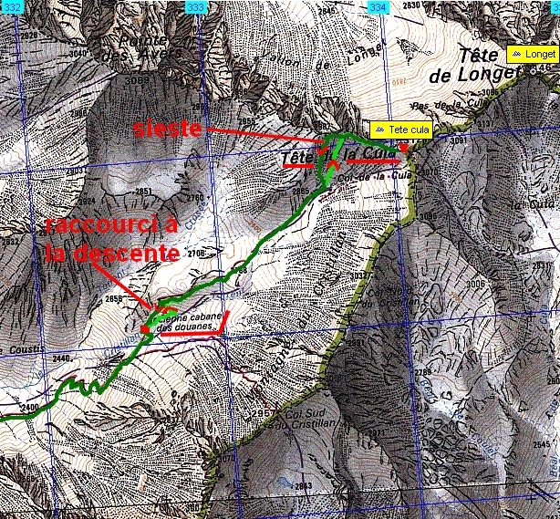
Tęte
de La Cula – Ceillac
(05) - - - 15/10/11
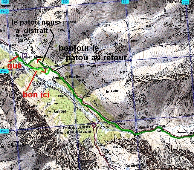
________ ici
il n'y a que
les imagettes ,
si une ou plusieurs photos vous intéressent en
grand format ,
merci de me faire un mail
Pour
les noms
des sommets ,
on
peut dire qu'ils sont bons
ŕ 90% ,
s'il y a erreur, ŕ vous de corriger, au moins vous avez la
direction !
Toute remarque constructive pour corriger les plus grosses erreurs ici sera acceptée par bnbd05@yahoo.fr merci
Retour Page Liste des Randos
* * * * * *
Attention : d'abords un rappel
EN MONTAGNE, CHACUN EST RESPONSABLE DE SA SÉCURITÉ .
Elle requiert également la conscience de ses propres capacités et de
ses limites propres, et implique par conséquent l'acceptation d'un
certain degré de risque. Par conséquent, les randonnées se font
sous votre propre responsabilité. L'auteur de ce site ne peut pas
garantir l'exactitude ni l'exhaustivité des indications contenues dans
ce site.
* * * * * *
2 autres petits conseils :
que l'on veuille prendre des photos ou juste regarder :on arręte d'abords de marcher
quand la marche avant n'est pas aisée , la marche arričre peut ętre salutaire
* * * * * *
* * * * * *
* * * * * *
ŕ l'ouest
ŕ l'est
ça caille sec depuis le départ !
soleil derričre nous
il faut mériter la chaleur aujourd'hui !
ouf ! le soleil et la chaleur pour bientôt !
et la Tęte de la Cula pointe
restaurés, on repart
premier palier ...
mais le plus dur reste ŕ faire !
voilŕ, l'effort est lŕ, ŕ g.
prendre des photos ça permet aussi de reprendre son souffle, la Tęte de la Cula vue de côté
et la cręte avec les cols du Cristillant
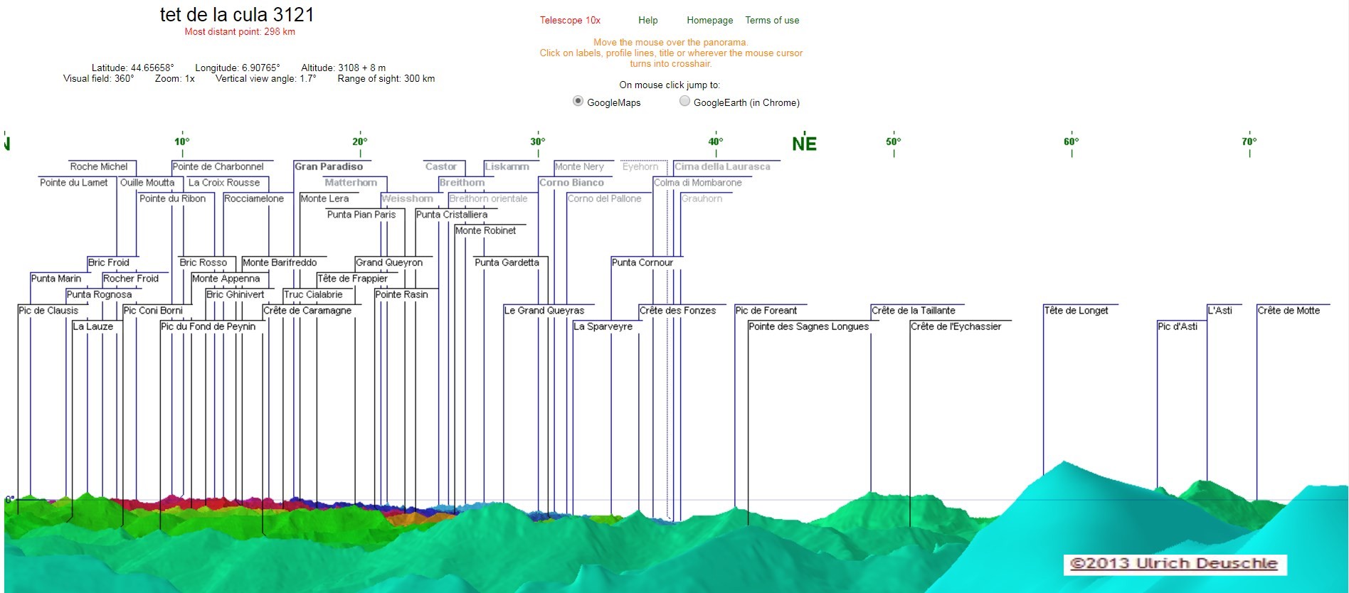
a la crete _3032.JPG premier 360° avant le sommet ---->le panorama des photos 8928 ŕ 8950 est le premier des 2 ŕ la fin
le Peouvou ŕ d. ?
la Font Sancte
le Pic des heuvičres arričre g.
vers le Pas du curé, ŕ g. la Colette Verte, au fond, la Main de Dieu, ŕ d. la Mamelle et la Pointe de la Saume
la Pointe de Serre et le Mourre-Froid de g.
au sud-ouest
la Tęte des Avers prčs de nous( image fin du pano 1 et début du pano 2, situés ŕ la fin )
on attaque le sérieux
on en reparlera plus loin
les Aiguilles d'Arves ŕ g. et la Tęte de Cassille au centre
le Pic de Rochebrune avec le Mont Thabor caché derričre logiquement,
alors qui ŕ sa droite avec la petite tache de neige ? le Cheval
Blanc ? Roche Bernaude ?
je pense toujours Vanoise au fond
lŕ je ne sais ?
celui qui fait coucou lŕ dans l'encoche doit ętre le Mt Blanc au cap 360° ( l'Observatoire étant ŕ 2° )
l'Observatoire du Pic de Château-Renard...
...ŕ St Véran
le Col de Longet et au fond ŕ g. sommet enneigé non identifié mais hors
de France ŕ priori, par contre celui que l'on distingue ŕ peine, prčs
du pic de d. serait le Cervin
tout le massif ici : le Grand Paradis ?
le Grand Queyras derričre le Queyron
le Rouchon ? devant le Pic de Foréant
la Taillante ? au fond
le Col de Cnamoussičre
le Pain de Sucre derričre Caramantran et ? le panorama des photos 8950 ŕ 8974 est le second des 2 ŕ la fin
la Tęte de Longet
-------> la Tęte de la Cula
retour en arričre en zoomant moins --->
----> pour voir St Véran et Molines en Q
Panorama virtuel ŕ 360° @
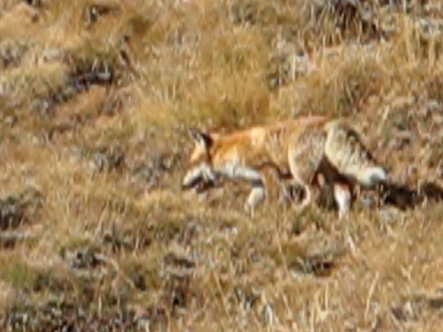
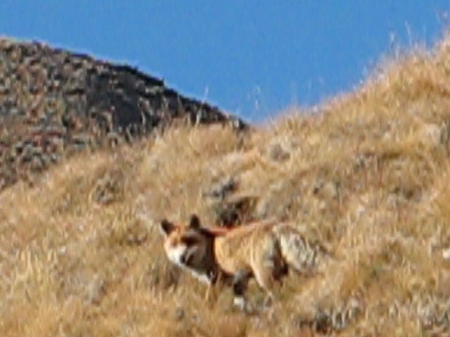
------------------------------------------------aprčs une petite galopade sur le chemin, je retrouve la bęte qui ne nous a pas détectés , et je peux faire quelques secondes de vidéo d'oů sont extraites ces 3 photos...
beaucoup plus roux au poitrail qu'ŕ l'arričre du corps, je ne sais si c'est une généralité chez ces bestioles ?
il tourne la tęte et me découvre , il va décamper aussitôt ŕ vive allure ne demandant pas son reste !
* * * * * *8928a50 pour ces 2 panoramas, la focale ne permet pas de zoomer dans les panoramas * * * * * * Panorama 8950a74 Page générée le 15/10/2011
compteur de visite html
website tracker widget