| - Canon PS A710 (200x) | |
IMG_3186_pk.JPG (4 MO) 2592 x 1944 quelle surprise ! des primevères marginées sur le bord de piste, en arrivant de Gaudeissard via Montourioux |
IMG_3187.JPG (3.64 MO) 2592 x 1944 environ 100m avant le virage en épingle de La Couratine, juste avant d'arriver |
IMG_3188.JPG (3.65 MO) 2592 x 1944 |
IMG_3189.JPG (2.25 MO) 2592 x 1944 elles ne sont pas bleues comme celles du lac du Crachet, mais très jolies tout de même, et assez rares |
IMG_3190.JPG (3.01 MO) 2592 x 1944 et, de plus ! on va en voir des dizaines ... sinon plus, à partir de 1820m |
IMG_3191_8h47.JPG (2.33 MO) 2592 x 1944 la Tête de Louis XVI bien connue |
IMG_3192.JPG (2.17 MO) 2592 x 1944 |
IMG_3193.JPG (3 MO) 2592 x 1944 on va tourner dans le sens horaire, départ en face |
IMG_3194.JPG (3.39 MO) 2592 x 1944 et retour par là |
IMG_3195_9h01.JPG (1.98 MO) 2592 x 1944 gesse de printemps ? en très grand nombre tout au long de la balade |
IMG_3196.JPG (2.89 MO) 2592 x 1944 |
IMG_3197_9h27.JPG (2.32 MO) 2592 x 1944 de Costa Rouenda à l'Aupillon ... |
IMG_3198.JPG (2.01 MO) 2592 x 1944 |
IMG_3199.JPG (1.81 MO) 2592 x 1944 le Cimet, à l'extrême droite, à flanc, dans la trouée ? |
IMG_3200.JPG (1.43 MO) 2592 x 1944 la Grande Epervière le Gd Bérard et la Chalanche |
IMG_3201.JPG (1.58 MO) 2592 x 1944 Plastres et Rocher des Cailles |
IMG_3202.JPG (1.6 MO) 2592 x 1944 |
IMG_3203.JPG (1.71 MO) 2592 x 1944 col de l'Ane dans le "cirque" à g. |
IMG_3204.JPG (1.86 MO) 2592 x 1944 Pic Silhourais et Costa Rouenda à g. |
IMG_3205.JPG (2.34 MO) 2592 x 1944 |
IMG_3206.JPG (2.15 MO) 2592 x 1944 |
IMG_3207.JPG (2.16 MO) 2592 x 1944 la Montagnette avec le Pouzenc à l'arrière Boussolenc à sa d. ? |
IMG_3208.JPG (1.74 MO) 2592 x 1944 le Pouzenc derrière |
IMG_3209_9h37.JPG (2.55 MO) 2592 x 1944 pleins d'anémones aussi, et des myosotis |
IMG_3210.JPG (1.6 MO) 2592 x 1944 ça, au casse-croûte .... on ne connait pas, bien que ..... Hépatica nobilis nous dit Franck LD : merci |
IMG_3211.JPG (2.92 MO) 2592 x 1944 nous sommes impardonnables de ne pas avoir reconnu l'Hépatique trilobée .... nous ne connaissons qu'elle !!! |
IMG_3212.JPG (1.68 MO) 2592 x 1944 il faut dire, à notre décharge, que, feuilles non déroulées et fleur bien amochée, elle nous a bien berné ! elle ne nous y reprendra pas |
IMG_3213_9h59.JPG (2.01 MO) 2592 x 1944 et vers 1820m on retrouve les primevères marginées qui nous accompagnerons presque jusqu'à la cabane |
IMG_3214.JPG (2.07 MO) 2592 x 1944 |
IMG_3215.JPG (1.79 MO) 2592 x 1944 |
IMG_3216.JPG (1.97 MO) 2592 x 1944 |
IMG_3217.JPG (2.3 MO) 2592 x 1944 |
IMG_3218.JPG (2.95 MO) 2592 x 1944 |
IMG_3219_10h21.JPG (2.74 MO) 2592 x 1944 coup d'oeil vers la Séolane des Besses |
IMG_3220_10h24.JPG (1.84 MO) 2592 x 1944 plein est, on verra mieux plus loin, là, on attaque la crête de Château-Renard |
IMG_3221.JPG (1.39 MO) 2592 x 1944 la Méa, petite, au centre ... |
IMG_3222.JPG (1.39 MO) 2592 x 1944 à g. Tête Dure d'Enchastrayes et Rouchinière ... |
IMG_3223_10h30.JPG (3.06 MO) 2592 x 1944 alors là, on est au passage le plus délicat, on va se faire un peu violence et peur, et avoir le plaisir de voir, ensuite, que l'on pouvait contourner par la droite !!! |
IMG_3224.JPG (3.42 MO) 2592 x 1944 |
IMG_3225.JPG (3.13 MO) 2592 x 1944 |
IMG_3226.JPG (3.05 MO) 2592 x 1944 |
IMG_3227_10h50.JPG (3.92 MO) 2592 x 1944 des crottes de Coq de Bruyère me dit le chef flore JP ( flore ....... intestinale ici ) |
IMG_3228.JPG (3.43 MO) 2592 x 1944 |
IMG_3229.JPG (3.03 MO) 2592 x 1944 on perd un peu d'altitude pour naviguer parmi les rochers de plus en plus nombreux, coin très agréable |
IMG_3230.JPG (3.74 MO) 2592 x 1944 |
IMG_3231.JPG (3.44 MO) 2592 x 1944 |
IMG_3232.JPG (3.59 MO) 2592 x 1944 |
IMG_3233_10h59.JPG (2.83 MO) 2592 x 1944 très joli aussi ici |
IMG_3234.JPG (2.91 MO) 2592 x 1944 |
IMG_3235.JPG (2.88 MO) 2592 x 1944 |
IMG_3236.JPG (3.4 MO) 2592 x 1944 |
IMG_3237.JPG (2.52 MO) 2592 x 1944 |
IMG_3238.JPG (2.28 MO) 2592 x 1944 |
IMG_3239.JPG (2.92 MO) 1944 x 2592 |
IMG_3240_11h30.JPG (3.37 MO) 2592 x 1944 |
IMG_3241.JPG (3.1 MO) 2592 x 1944 |
IMG_3242.JPG (2.7 MO) 2592 x 1944 |
IMG_3243.JPG (1.67 MO) 2592 x 1944 |
IMG_3244.JPG (1.51 MO) 2592 x 1944 l'Aupillon |
IMG_3245.JPG (1.57 MO) 2592 x 1944 l'Aupet caché |
IMG_3246_11h46.JPG (2.73 MO) 2592 x 1944 voilà, on arrive à la cabane qui est à notre droite en face, la cote 2339m |
IMG_3247.JPG (2.5 MO) 2592 x 1944 le col de Terres Blanches est là devant avec l'Ailette derrière |
IMG_3248.JPG @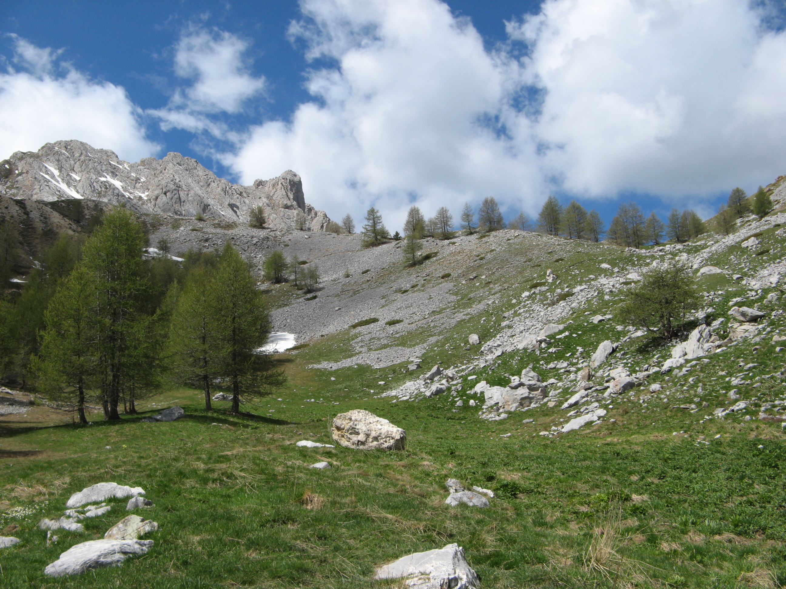 (2.68 MO) 2592 x 1944 le chemin part à d. au névé, pour contourner le pierrier |
IMG_3249.JPG (2.97 MO) 2592 x 1944 et apparait la Séolane des Besses |
IMG_3250.JPG (2.48 MO) 2592 x 1944 |
IMG_3251.JPG (2.59 MO) 2592 x 1944 |
IMG_3252.JPG (2.89 MO) 2592 x 1944 |
IMG_3253.JPG (2.63 MO) 2592 x 1944 |
IMG_3254.JPG (2.56 MO) 2592 x 1944 |
IMG_3255.JPG (3.06 MO) 2592 x 1944 |
IMG_3256.JPG (3.06 MO) 2592 x 1944 |
IMG_3257.JPG (2.98 MO) 2592 x 1944 et la cabane à son pied sud-est |
IMG_3258.JPG (2.64 MO) 2592 x 1944 |
IMG_3259.JPG (3 MO) 2592 x 1944 |
IMG_3260.JPG (2.19 MO) 2592 x 1944 |
IMG_3261.JPG (1.77 MO) 2592 x 1944 |
IMG_3262.JPG (2.02 MO) 2592 x 1944 |
IMG_3263.JPG (2.12 MO) 2592 x 1944 |
IMG_3264.JPG (2.41 MO) 2592 x 1944 le col est à peu près dans cet axe mais le piquet n'est pas visible d'ici ? |
IMG_3265.JPG (2.5 MO) 2592 x 1944 |
IMG_3266.JPG (2.49 MO) 2592 x 1944 |
IMG_3267.JPG (2.22 MO) 2592 x 1944 |
IMG_3268.JPG (2.32 MO) 2592 x 1944 |
IMG_3269.JPG (2.65 MO) 2592 x 1944 |
IMG_3270.JPG (3.72 MO) 2592 x 1944 on se tâte pour manger près du torrent ... |
IMG_3271.JPG (3.68 MO) 2592 x 1944 puis on décide de pousser jusqu'au col |
IMG_3272.JPG (1.93 MO) 2592 x 1944 le Gd Bérard |
IMG_3273_11h55.JPG (1.85 MO) 2592 x 1944 Pointe Fine à d. |
IMG_3274.JPG (1.52 MO) 2592 x 1944 Cuguret et Siguret au tiers d. |
IMG_3275.JPG (1.5 MO) 2592 x 1944 |
IMG_3276.JPG (1.5 MO) 2592 x 1944 |
IMG_3277.JPG (1.52 MO) 2592 x 1944 |
IMG_3278.JPG (1.66 MO) 2592 x 1944 |
IMG_3279.JPG (1.65 MO) 2592 x 1944 |
IMG_3280.JPG (1.72 MO) 2592 x 1944 |
IMG_3281.JPG (2.51 MO) 2592 x 1944 la Petite Séolane ... est celle à l'arrière |
panorama vers l'est @ 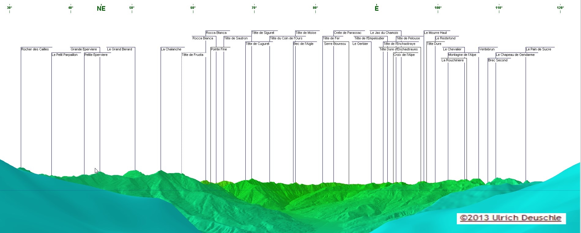 |
panorama vers l'ouest @ 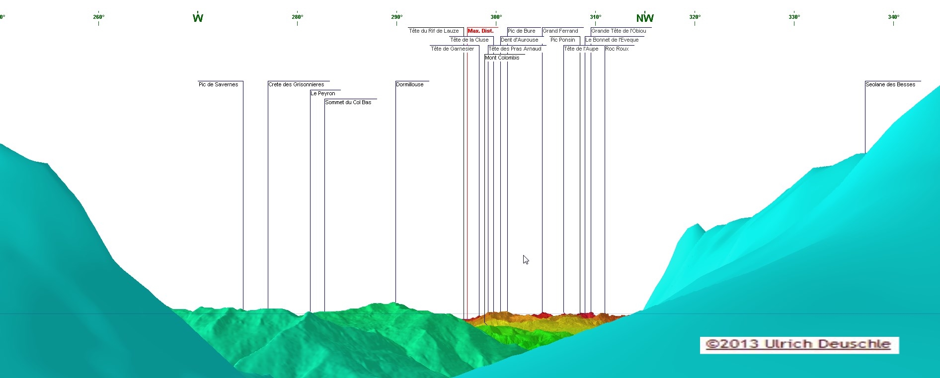 |
IMG_3282_12h02.JPG (2.24 MO) 2592 x 1944 la tête de la troupe est arrivée au piquet on va monter un peu vers la SdB pour manger à l'abri du vent qui est modéré |
IMG_3283_12h53.JPG (2 MO) 2592 x 1944 pendant le repas, quelques photos du panorama et de quelques 4 pattes, avant la sieste |
IMG_3284.JPG (2.13 MO) 2592 x 1944 |
IMG_3285.JPG (2.31 MO) 2592 x 1944 |
IMG_3286.JPG (2.32 MO) 2592 x 1944 |
IMG_3287.JPG (2.27 MO) 2592 x 1944 |
IMG_3288.JPG (2.08 MO) 2592 x 1944 |
IMG_3289.JPG (2.03 MO) 2592 x 1944 |
IMG_3290.JPG (2.06 MO) 2592 x 1944 |
IMG_3291.JPG (2.23 MO) 2592 x 1944 |
IMG_3292_13h04.JPG (2.68 MO) 2592 x 1944 au pied de l'Ailette |
IMG_3293.JPG (1.18 MO) 2592 x 1944 |
IMG_3295.JPG (1.44 MO) 2592 x 1944 |
IMG_3296.JPG (3.46 MO) 2592 x 1944 |
IMG_3298_13h08.JPG (3.53 MO) 2592 x 1944 |
IMG_3299.JPG (1.49 MO) 2592 x 1944 |
IMG_3301_13h22.JPG (2.18 MO) 2592 x 1944 pendant la sieste |
IMG_3302.JPG (2.72 MO) 2592 x 1944 |
IMG_3303.JPG (2.4 MO) 2592 x 1944 |
IMG_3304_13h55.JPG (1.78 MO) 2592 x 1944 |
IMG_3305.JPG (1.63 MO) 2592 x 1944 |
IMG_3306.JPG (1.65 MO) 2592 x 1944 |
IMG_3307.JPG (1.64 MO) 2592 x 1944 |
IMG_3308.JPG (1.56 MO) 2592 x 1944 |
IMG_3309.JPG (1.56 MO) 2592 x 1944 |
IMG_3310.JPG (1006 KO) 2592 x 1944 |
IMG_3311.JPG (1.48 MO) 2592 x 1944 là j'y ai cru voir la Tête de Moïse, au fond, au centre |
IMG_3312_14h10.JPG (2.33 MO) 2592 x 1944 sieste terminée, on est reparti et je suis épaté de la longueur de cette Séolane qui a 6 cotes à plus de 2000m sur une longueur de 1,5 km env. |
IMG_3313.JPG (2.54 MO) 2592 x 1944 |
IMG_3314.JPG (2.36 MO) 2592 x 1944 |
IMG_3315.JPG (2.39 MO) 2592 x 1944 |
IMG_3316_14h21.JPG (2.42 MO) 2592 x 1944 là on est à d. de l'Ailette |
IMG_3317.JPG (3.23 MO) 2592 x 1944 |
IMG_3318.JPG (2.24 MO) 2592 x 1944 |
IMG_3319.JPG (2.36 MO) 2592 x 1944 |
IMG_3320.JPG (2.87 MO) 2592 x 1944 |
IMG_3321_14h23.JPG (3.32 MO) 2592 x 1944 sur ce rocher, les 2 derniers pieds de primevère marginée observés ce jour |
IMG_3322.JPG (2.44 MO) 2592 x 1944 |
IMG_3323.JPG (3.07 MO) 2592 x 1944 |
IMG_3324.JPG (3.12 MO) 2592 x 1944 |
IMG_3325_14h38.JPG (1.83 MO) 2592 x 1944 je prends le sommet du Pinet fait jadis |
IMG_3327_14h45.JPG (2.56 MO) 2592 x 1944 |
IMG_3328.JPG (2.7 MO) 2592 x 1944 |
IMG_3329.JPG (2.92 MO) 2592 x 1944 |
IMG_3330.JPG (3.26 MO) 2592 x 1944 |
IMG_3331_15h14.JPG (2.23 MO) 2592 x 1944 et nous ré-apparait Louis XVI and Co |
IMG_3332.JPG (2.47 MO) 2592 x 1944 sans doute le Pessièou à d. derrière |
IMG_3333.JPG (2.43 MO) 2592 x 1944 |
IMG_3334.JPG (1.91 MO) 2592 x 1944 Dormillouse à d. |
IMG_3335.JPG (1.6 MO) 2592 x 1944 |
IMG_3336.JPG (1.83 MO) 2592 x 1944 Pic de Bernardez à g. ? |
IMG_3337.JPG (1.65 MO) 2592 x 1944 le Peyron au centre |
IMG_3338.JPG (1.89 MO) 2592 x 1944 |
IMG_3339.JPG (2.01 MO) 2592 x 1944 vers le Gd Morgon à g. |
IMG_3340.JPG (2.1 MO) 2592 x 1944 Joug de l'Aigle à d. de Pessièou ? |
IMG_3341_15h18.JPG (1.65 MO) 2592 x 1944 Roche Bénite ? |
IMG_3342_15h29.JPG (2.61 MO) 2592 x 1944 la surprise pour clore la journée, des Clématites des Alpes |
IMG_3343.JPG (2.18 MO) 2592 x 1944 |
IMG_3344.JPG (2.29 MO) 2592 x 1944 |
IMG_3345.JPG (1.87 MO) 2592 x 1944 voilà, sur la fin des pissenlits ..... c'est tout |
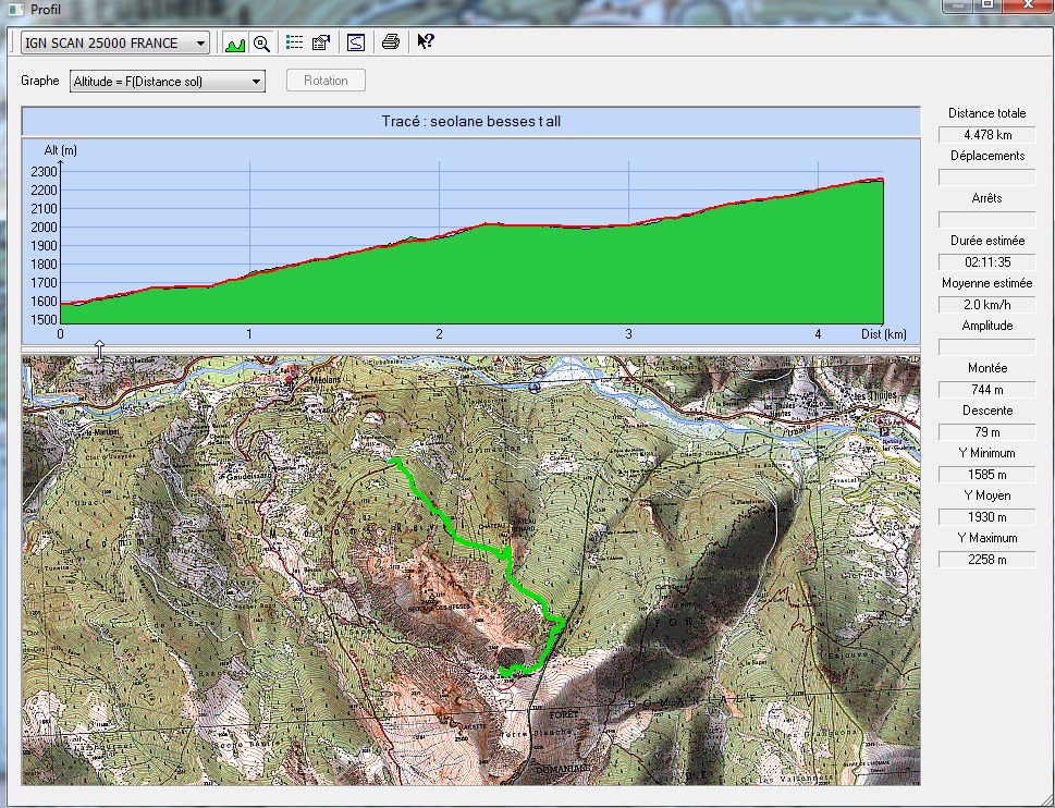
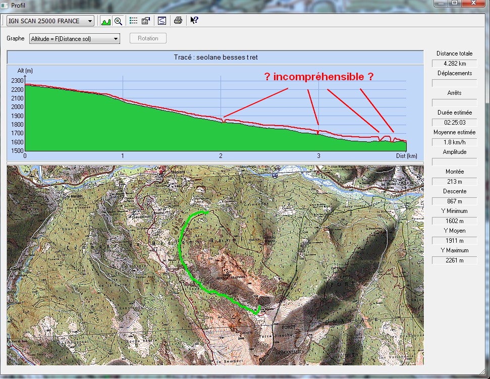
trace.jpg @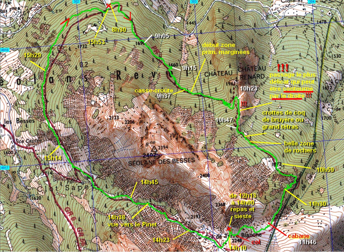 (1.45 MO) 1173 x 858 | Donc une bien belle balade que je pensais ne pas mener à son terme car le dénivelé est assez grand pour moi maintenant mais que je suis très content d'avoir fait surtout avec le grand nombre de belles fleurs vues 4,5 km et 820m en cumulé pour l'aller @ 4,3 km et 800m ? pour le retour ( 3 zones inexpliquées au GPS : variations barom. ? ) @ De Méolans - Revel, prendre à Gaudeissard à g. la piste vers Montourioux et la Couratine, après cette dernière, à droite à l'épingle, env. 300m, on est arrivé |
| |
|
 _Guest book