| - Canon PS A710 (200x) | |
Rappel : les photos avec ce sigle @ sont directement cliquables IMG_4549_09h11_arrivée en crête.JPG notre trace 
(1.39 MO) 2592 x 1944 arrivés ici, on en a plein le dos ............... de la bruine, le sac aussi |
15 images en grand format ( 76Mo ) et 1 vidéo ( 97Mo ) ici :  les photos concernées auront ce logo IMG_4550.JPG 
(1.34 MO) 2592 x 1944 |
IMG_4551.JPG
(1.39 MO) 2592 x 1944 sale temps ( pour le moment ) mais on a bon espoir |
IMG_4552_09h30_casse-croûte.JPG
(1.38 MO) 2592 x 1944 merci aux petits pins qui nous ont abrités en crête pour le casse-croûte |
IMG_4553.JPG
(1.37 MO) 2592 x 1944 |
IMG_4554.JPG 
(1.35 MO) 2592 x 1944 les sommets jouent à cache-cache avec nous |
IMG_4555.JPG
(1.34 MO) 2592 x 1944 |
IMG_4556.JPG
(1.33 MO) 2592 x 1944 |
IMG_4557.JPG
(1.38 MO) 2592 x 1944 |
IMG_4558.JPG
(1.38 MO) 2592 x 1944 |
IMG_4559.JPG
(1.37 MO) 2592 x 1944 |
IMG_4560_10h15_arrivée au cairn sommet.JPG 
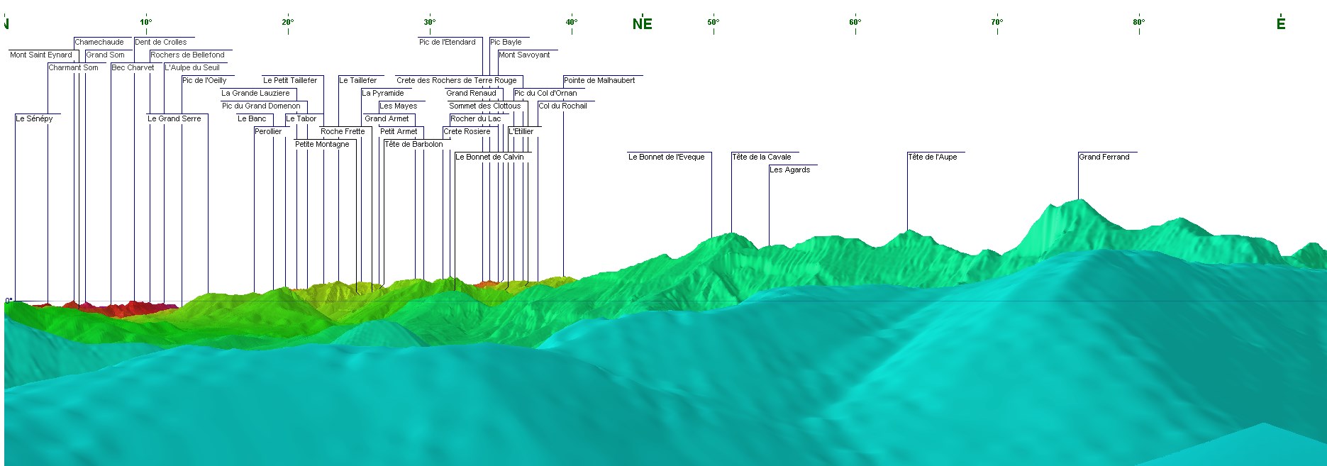
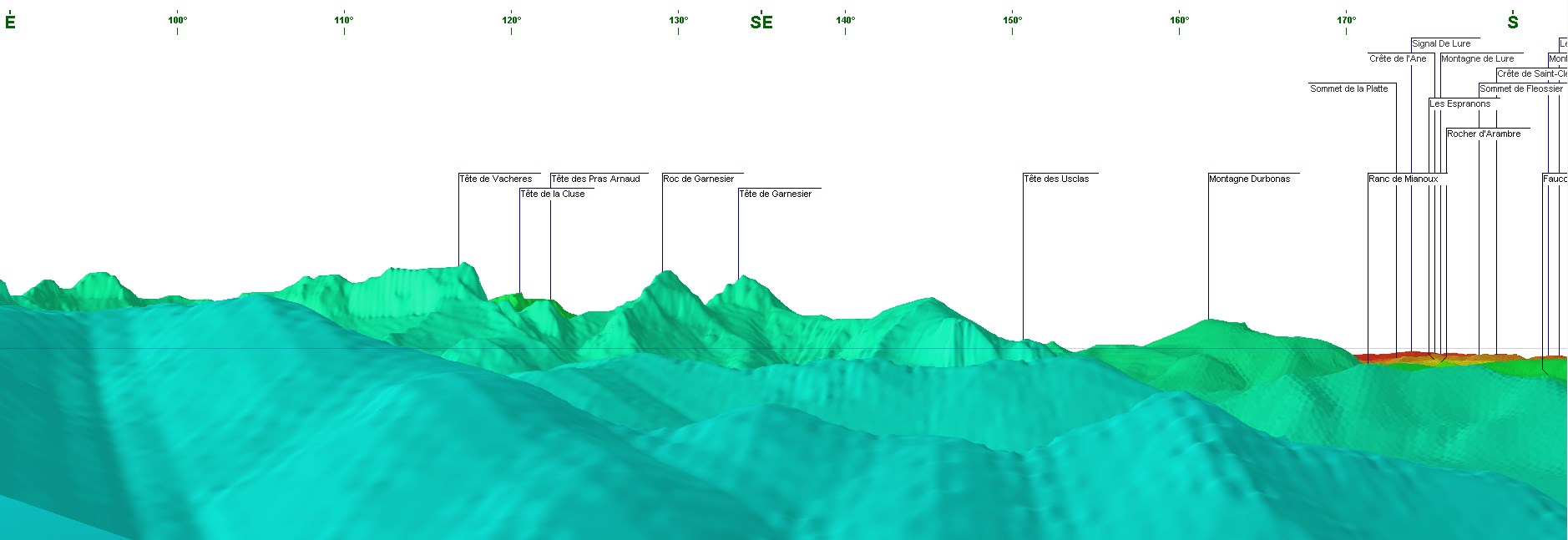
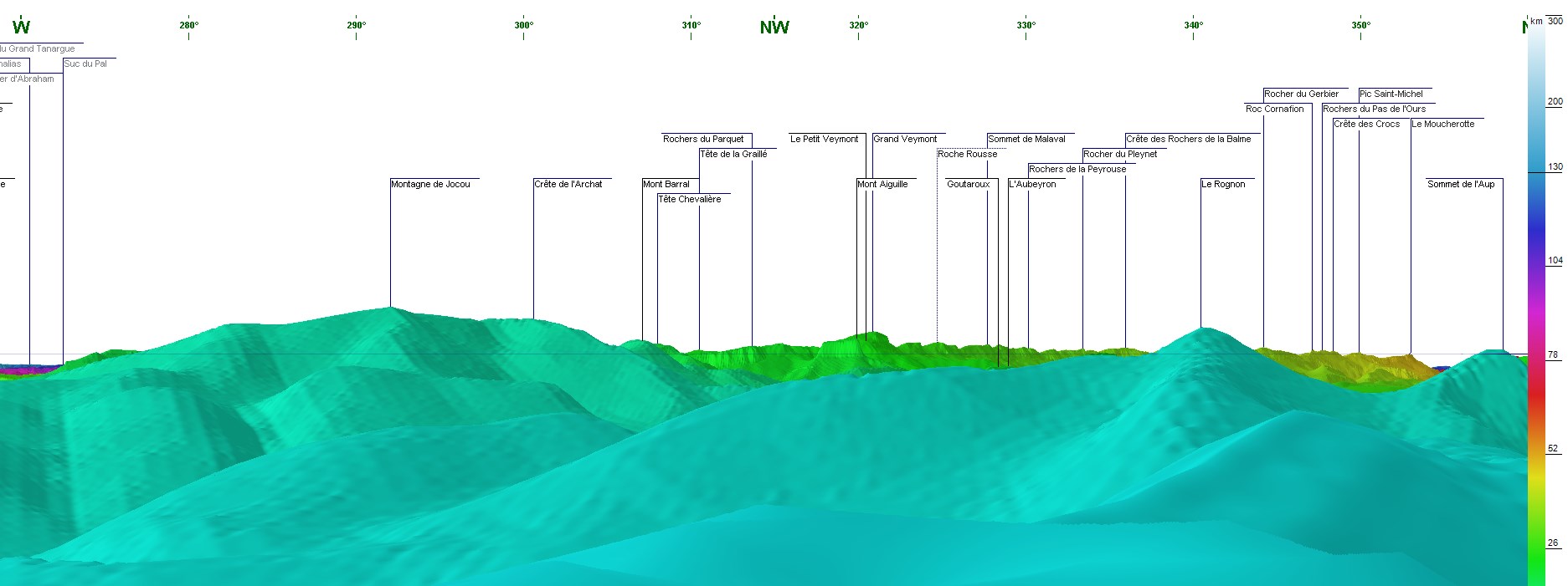
(1.8 MO) 2592 x 1944 pour les sommets, nommés par moi ou pas, vous pouvez vous aider de la rubrique " repérage " ICI |
IMG_4561.JPG
(1.48 MO) 2592 x 1944 Mont Aiguille et Gd Veymont |
IMG_4562.JPG
(1.43 MO) 2592 x 1944 Trois Becs |
IMG_4563.JPG
(1.44 MO) 2592 x 1944 |
IMG_4563_1_premier bloc de photos FUJI.JPG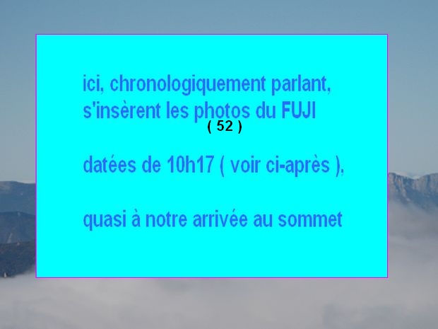
(1.2 MO) 2592 x 1944 |
IMG_4564_10h33_pano d'arrivée.JPG
(2.19 MO) 2592 x 1944 |
IMG_4565.JPG
(1.87 MO) 2592 x 1944 |
IMG_4566.JPG
(1.5 MO) 2592 x 1944 |
IMG_4567.JPG
(1.47 MO) 2592 x 1944 |
IMG_4568.JPG 
(1.59 MO) 2592 x 1944 Obiou |
IMG_4569.JPG
(1.56 MO) 2592 x 1944 |
IMG_4570.JPG
(1.67 MO) 2592 x 1944 Gd Ferrand |
IMG_4571.JPG
(1.49 MO) 2592 x 1944 Roche Courbe |
IMG_4572.JPG
(1.51 MO) 2592 x 1944 |
IMG_4573.JPG
(1.53 MO) 2592 x 1944 |
IMG_4574.JPG
(1.51 MO) 2592 x 1944 |
IMG_4575.JPG
(1.5 MO) 2592 x 1944 |
IMG_4576.JPG
(1.35 MO) 2592 x 1944 |
IMG_4577.JPG
(1.35 MO) 2592 x 1944 |
IMG_4578.JPG 
(1.39 MO) 2592 x 1944 là, au fond, peut-être Duffre à g. et Chamouse à d. ?? |
IMG_4579.JPG
(1.42 MO) 2592 x 1944 |
IMG_4580.JPG
(1.41 MO) 2592 x 1944 |
IMG_4581.JPG
(1.4 MO) 2592 x 1944 |
IMG_4582.JPG
(1.34 MO) 2592 x 1944 |
IMG_4583.JPG
(1.33 MO) 2592 x 1944 |
IMG_4584.JPG
(1.33 MO) 2592 x 1944 |
IMG_4585.JPG
(1.29 MO) 2592 x 1944 |
IMG_4586.JPG
(1.72 MO) 2592 x 1944 |
IMG_4587.JPG
(1.7 MO) 2592 x 1944 |
IMG_4588_11h12_la puree.JPG
(2.24 MO) 2592 x 1944 |
IMG_4589.JPG
(2.28 MO) 2592 x 1944 |
IMG_4590.JPG
(2.12 MO) 2592 x 1944 |
IMG_4591.JPG 
(2.33 MO) 2592 x 1944 un bout de notre crête d'arrivée |
IMG_4592.JPG
(2.33 MO) 2592 x 1944 col de Tournerond par lequel nous sommes passés "avant la douche" |
IMG_4593_11h15_avant le repas.JPG
(2.38 MO) 2592 x 1944 on voit l'amélioration météo très nettement |
IMG_4594.JPG
(3.14 MO) 2592 x 1944 je ne les ai pas pris en photos, mais 7 vautours nous ont rendu visite |
IMG_4595.JPG
(2.19 MO) 2592 x 1944 ici direction du col de Jagène qui était notre autre choix |
IMG_4596.JPG
(2.18 MO) 2592 x 1944 |
IMG_4597.JPG
(2.19 MO) 2592 x 1944 |
IMG_4598.JPG
(1.71 MO) 2592 x 1944 |
IMG_4599.JPG 
(1.38 MO) 2592 x 1944 le Bonnet de Calvin émerge à peine, enneigés : Pic Etendard, Pic Bayle, Pic du Lac Blanc etc |
IMG_4600.JPG
(1.44 MO) 2592 x 1944 Dent de Crolles au centre |
IMG_4601.JPG
(1.44 MO) 2592 x 1944 Chamechaude et Grand Som au centre |
IMG_4601_1_2d bloc de photos FUJI.JPG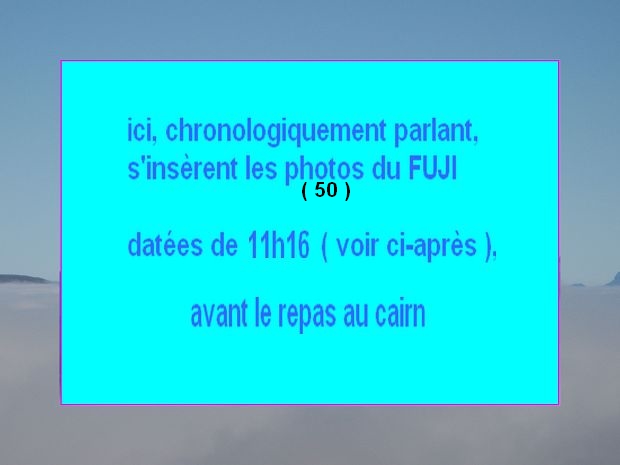
(1.22 MO) 2592 x 1944 |
IMG_4603_12h35_avant la sieste.JPG
(1.54 MO) 2592 x 1944 |
IMG_4604.JPG
(1.8 MO) 2592 x 1944 l'Aupillon et Serre Les Têtes vers le col de Grimone |
IMG_4605.JPG
(1.64 MO) 2592 x 1944 Quigouret à gauche et Toussière au centre |
IMG_4606.JPG
(1.4 MO) 2592 x 1944 Montagne de Durbonnas au fond |
IMG_4607.JPG
(1.44 MO) 2592 x 1944 au centre droit, au fond : Chamousset Borne, Gd et Petit Chamousset |
IMG_4608.JPG
(1.6 MO) 2592 x 1944 Roc et Tête de Garnesier |
IMG_4609.JPG
(1.74 MO) 2592 x 1944 à droite de T de Vachères ( au centre ) : col des Aiguilles et Bure derrière |
IMG_4610.JPG
(2.07 MO) 2592 x 1944 Pointe Feuillette au premier plan, centre |
IMG_4611.JPG
(1.62 MO) 2592 x 1944 col des Aiguilles en mieux |
IMG_4612.JPG
(1.92 MO) 2592 x 1944 |
IMG_4613.JPG
(2.02 MO) 2592 x 1944 |
IMG_4614.JPG
(1.98 MO) 2592 x 1944 |
IMG_4615.JPG
(2.01 MO) 2592 x 1944 |
IMG_4616.JPG
(1.91 MO) 2592 x 1944 |
IMG_4617.JPG 
(1.85 MO) 2592 x 1944 à g. de l' Obiou : Rattier avec sa longue arête au nord |
IMG_4618.JPG  
(1.76 MO) 2592 x 1944 à d. de l'Aiguille ( an centre ), on est vers la Pointe de Malhaubert ( neige ) |
IMG_4619.JPG
(1.65 MO) 2592 x 1944 |
IMG_4620.JPG @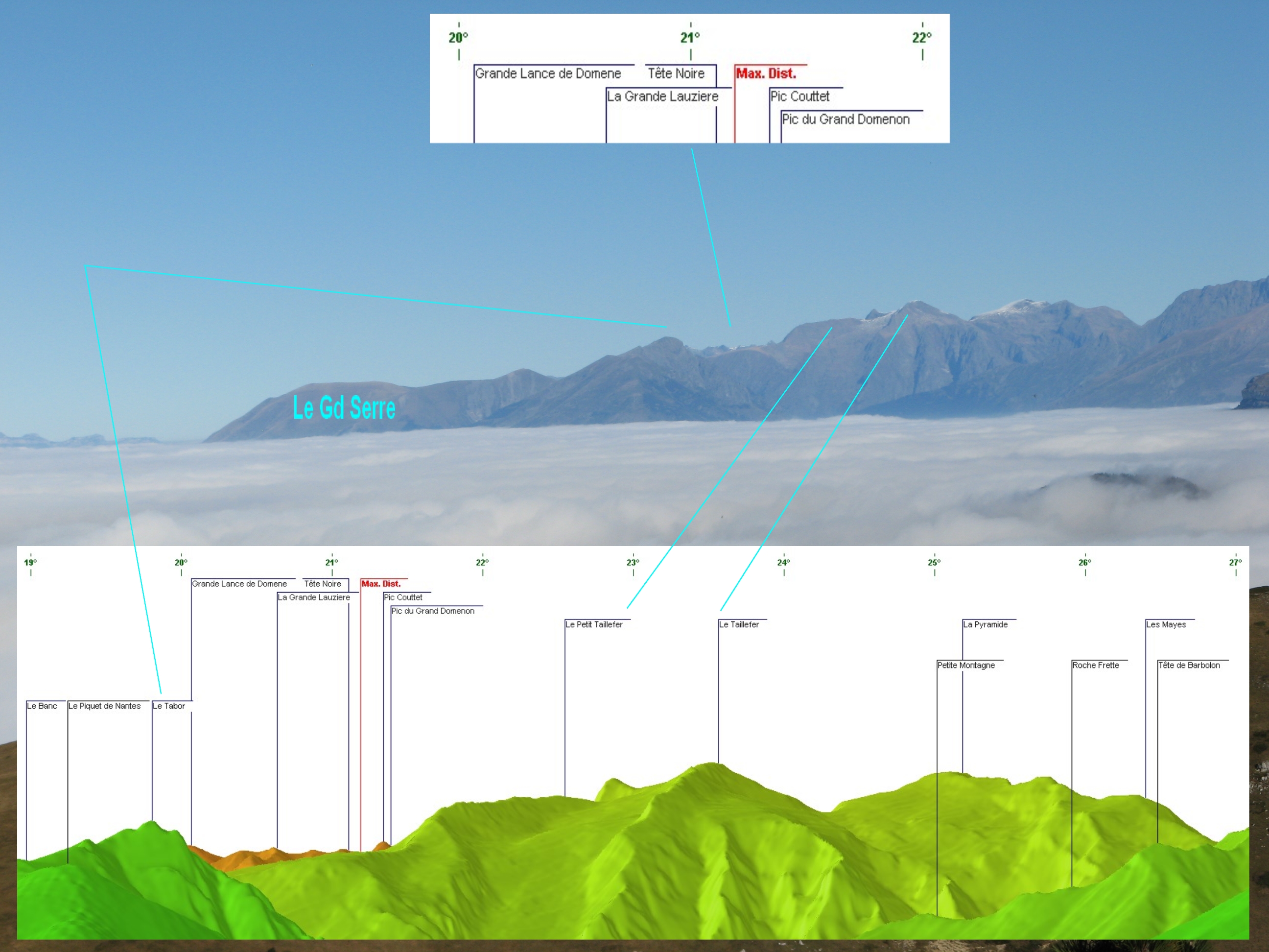
(1.58 MO) 2592 x 1944 |
IMG_4621.JPG 
(1.52 MO) 2592 x 1944 |
IMG_4622.JPG
(1.54 MO) 2592 x 1944 au centre l'Aup voisin du Rognon |
IMG_4623.JPG
(1.78 MO) 2592 x 1944 dans la trouée : du Rocher du Gerbier au Moucherotte ( cf W--N ) |
IMG_4624.JPG 
(1.84 MO) 2592 x 1944 malheureusement, le Rognon nous cache les 2 Soeurs et les 2 Moucherolles |
IMG_4625.JPG
(1.98 MO) 2592 x 1944 |
IMG_4626.JPG
(1.71 MO) 2592 x 1944 au premier plan : le Boutouret |
IMG_4627.JPG
(1.75 MO) 2592 x 1944 au centre, au flanc du Jocou : le Mont Barral et la Tête Chevalière ( cf W--N ) |
IMG_4628.JPG
(1.84 MO) 2592 x 1944 |
IMG_4629.JPG 
(1.84 MO) 2592 x 1944 le Jocou avec sa cabane à g. ... si si ... croyez-moi |
IMG_4630.JPG
(1.72 MO) 2592 x 1944 |
IMG_4631.JPG
(1.62 MO) 2592 x 1944 |
IMG_4632.JPG
(1.49 MO) 2592 x 1944 il y aurait le Cornafion ici au centre |
IMG_4633.JPG
(1.34 MO) 2592 x 1944 là, au centre, on voit le Pic St Michel |
IMG_4634.JPG
(1.43 MO) 2592 x 1944 |
IMG_4635.JPG 
(1.37 MO) 2592 x 1944 à d. de l'Aup on aurait le Sénépy ( voisin de La Mure ) |
IMG_4636.JPG
(1.27 MO) 2592 x 1944 |
IMG_4637.JPG 
(1.3 MO) 2592 x 1944 en partie d. la Dent de Crolles ( cf N--E ) |
IMG_4638.JPG
(1.4 MO) 2592 x 1944 |
IMG_4639.JPG
(1.57 MO) 2592 x 1944 |
IMG_4640.JPG
(1.72 MO) 2592 x 1944 |
IMG_4641.JPG
(1.58 MO) 2592 x 1944 |
IMG_4642_13h18.JPG
(1.73 MO) 2592 x 1944 |
IMG_4643.JPG
(1.62 MO) 2592 x 1944 |
IMG_4644.JPG
(1.53 MO) 2592 x 1944 |
IMG_4645.JPG
(1.61 MO) 2592 x 1944 |
IMG_4646.JPG 
(1.49 MO) 2592 x 1944 les brumes se sont bien évaporées |
IMG_4647.JPG
(1.66 MO) 2592 x 1944 |
IMG_4648.JPG 
(1.68 MO) 2592 x 1944 là on a un beau Bonnet de Calvin |
IMG_4649.JPG
(1.81 MO) 2592 x 1944 |
IMG_4650.JPG 
(1.6 MO) 2592 x 1944 les éclairages aussi ont bien changés |
IMG_4651.JPG
(1.76 MO) 2592 x 1944 |
IMG_4652.JPG
(1.66 MO) 2592 x 1944 |
IMG_4653.JPG
(1.56 MO) 2592 x 1944 |
IMG_4654.JPG
(1.47 MO) 2592 x 1944 |
IMG_4655.JPG
(1.37 MO) 2592 x 1944 |
IMG_4656_13h54.JPG
(2.24 MO) 2592 x 1944 |
IMG_4657.JPG 
(2.43 MO) 2592 x 1944 on aurait atterri dans cette zone par les pointillés, c'est en biais ici |
IMG_4658.JPG
(2.65 MO) 2592 x 1944 voilà la bosse que nous avons fait, ce matin, dans la bruine |
IMG_4659_13h57.JPG
(2.96 MO) 2592 x 1944 notre chemin de descente est là, bien net |
IMG_4660.JPG
(2.8 MO) 2592 x 1944 |
IMG_4661_14h23.JPG 
(2.91 MO) 2592 x 1944 un coup d'oeil à notre crête |
IMG_4662.JPG 
(2.91 MO) 2592 x 1944 .... et au col |
IMG_4663.JPG
(2.83 MO) 2592 x 1944 |
IMG_4664.JPG
(3.11 MO) 2592 x 1944 |
IMG_4665_14h31.JPG 
(3.44 MO) 2592 x 1944 on a là, en face, en bas, le chemin qui part vers le col de Jagène |
IMG_4666.JPG
(3.02 MO) 2592 x 1944 |
IMG_4667.JPG
(2.95 MO) 2592 x 1944 |
Notre montée a été gâchée par un vent fort et froid nous apportant les bruines dans le dos à partir du col Tournerond, jusqu'à la crête + ensuite, à l'abri du vent, et en attendant la dissipation des brumes, nous avons profité d'un 360° excellent ---------------- pour le chemin en pointillé, nous avons eu peur de la pente de cette "draye" ?, que l'on devine sur la photo 6626 ( chemin d'ailleurs car basculant de l'autre côté de la crête ) et que l'on voyait nettement du cairn mais il ne devait pas être beaucoup plus dangereux que le chemin pris pour le retour ... note ajoutée ultérieurement, nous avons essayé de prendre cette trace "supposée" à la montée, une fois suivante, nous nous sommes bagarrés ..... ça n'a pas été une réussite, alors, à oublier |
notre trace @ 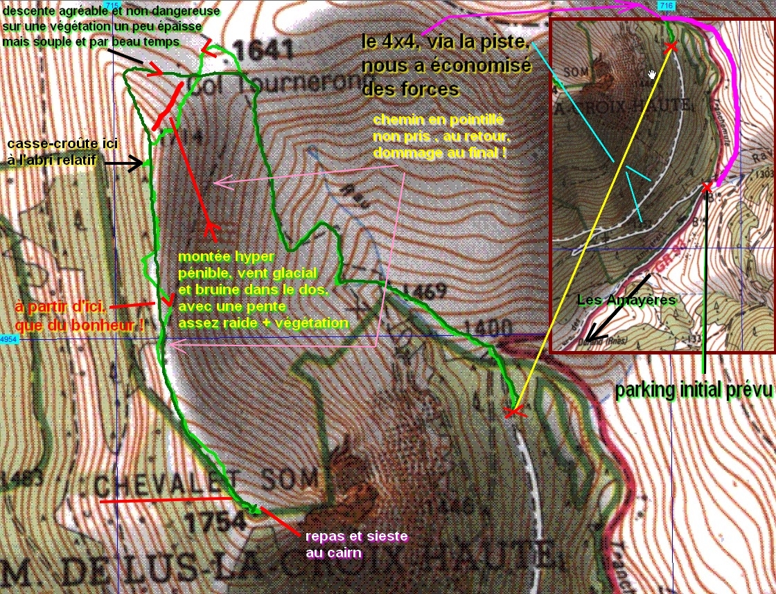 retour |
|
|
|
 pour visionner dans de bonnes conditions ---->


 _Guest book