| - Canon PS A710 (200x) | |
IMG_0583_08h41.JPG (2.39 MO) 3072 x 2304 le culminant vu du parking |
IMG_0584.JPG (2.22 MO) 3072 x 2304 |
IMG_0585_09h03.JPG (4.14 MO) 2304 x 3072 |
IMG_0586.JPG (2.84 MO) 3072 x 2304 |
IMG_0587_09h34.JPG (2.74 MO) 3072 x 2304 nous montons par le côté le plus accidenté, par les marnes où certains passages sont plus hard, voir trace à la fin |
IMG_0588.JPG (3.07 MO) 3072 x 2304 ce chemin peut être encore plus risqué si passages humides, c'est pour cela que nous l'avons pris pour "aller" et là c'était sec |
IMG_0589.JPG (2.95 MO) 3072 x 2304 |
IMG_0590.JPG (3.82 MO) 3072 x 2304 le stade et notre véhicule au parking de Sahune |
IMG_0591_10h22.JPG (3.49 MO) 3072 x 2304 Villeperdrix |
IMG_0592.JPG (3.93 MO) 3072 x 2304 |
IMG_0593.JPG (2.24 MO) 3072 x 2304 |
IMG_0594_10h26.JPG (2.99 MO) 3072 x 2304 |
IMG_0595.JPG (2.46 MO) 3072 x 2304 |
IMG_0596.JPG (3.74 MO) 3072 x 2304 |
IMG_0597_10h54.JPG (5.27 MO) 3072 x 2304 on a attaqué la remontée... dure dure au soleil |
IMG_0598.JPG (3.47 MO) 3072 x 2304 |
IMG_0599_11h16.JPG (4.31 MO) 3072 x 2304 |
IMG_0600.JPG (4.09 MO) 3072 x 2304 |
IMG_0602_11h58.JPG (4.03 MO) 3072 x 2304 |
IMG_0603.JPG (3.86 MO) 3072 x 2304 |
IMG_0604_14h19.JPG (5.05 MO) 3072 x 2304 ferme du plus Haut Laup où nous allons manger et siester |
IMG_0605.JPG (4.3 MO) 3072 x 2304 |
IMG_0606.JPG (4.6 MO) 3072 x 2304 |
IMG_0607.JPG (4.42 MO) 3072 x 2304 |
IMG_0608.JPG (4.58 MO) 3072 x 2304 |
IMG_0609_14h22.JPG (5.18 MO) 3072 x 2304 notre banc amélioré |
IMG_0610_14h45.JPG (5.19 MO) 2304 x 3072 |
IMG_0611.JPG (5.21 MO) 2304 x 3072 |
IMG_0612_15h01.JPG (3.9 MO) 2304 x 3072 rarement on en avait vu dans ce bel état de floraison |
IMG_0613.JPG (2.68 MO) 2304 x 3072 |
IMG_0614.JPG (2.37 MO) 3072 x 2304 |
IMG_0615_15h10.JPG (3.74 MO) 3072 x 2304 on arrive au point bas, vers 890m |
IMG_0616.JPG (2.88 MO) 3072 x 2304 |
IMG_0617.JPG (2.82 MO) 3072 x 2304 |
IMG_0618.JPG (3.28 MO) 3072 x 2304 |
IMG_0619.JPG (2.29 MO) 3072 x 2304 |
IMG_0620.JPG (2.24 MO) 3072 x 2304 |
IMG_0621_15h12.JPG (2.61 MO) 3072 x 2304 |
IMG_0622.JPG (2.18 MO) 3072 x 2304 près de Nyons |
IMG_0623_15h22.JPG (3.47 MO) 2304 x 3072 puis au culminant 936m |
IMG_0624.JPG (3.91 MO) 2304 x 3072 |
IMG_0625.JPG (2.52 MO) 3072 x 2304 |
IMG_0626.JPG (2.49 MO) 3072 x 2304 les aiguilles de rémuzat et le raton |
IMG_0627.JPG (3.1 MO) 3072 x 2304 Piégros |
IMG_0628.JPG (3.01 MO) 3072 x 2304 ici on aurait Garnesier, Ecrins et Tarsimoure |
IMG_0629.JPG (3.25 MO) 3072 x 2304 |
IMG_0630.JPG (3.34 MO) 3072 x 2304 Buisseron |
IMG_0631.JPG (2.84 MO) 3072 x 2304 col d'Ambonne au bout et Tuve |
IMG_0632.JPG (3.08 MO) 3072 x 2304 le Tuve au centre |
IMG_0633.JPG (4.02 MO) 3072 x 2304 |
IMG_0634.JPG (2.77 MO) 3072 x 2304 sud-est |
IMG_0635.JPG (3.33 MO) 3072 x 2304 on repart vers Angèle et Miélandre |
IMG_0636.JPG (3.19 MO) 3072 x 2304 |
IMG_0637.JPG (3.18 MO) 3072 x 2304 |
IMG_0638.JPG (3.19 MO) 3072 x 2304 |
IMG_0639.JPG (2.97 MO) 3072 x 2304 |
IMG_0640.JPG (3.19 MO) 3072 x 2304 |
IMG_0641.JPG (3.12 MO) 3072 x 2304 vers Nyons |
IMG_0642_15h50.JPG (2.66 MO) 3072 x 2304 on a attaqué la descente |
IMG_0643.JPG (2.45 MO) 3072 x 2304 |
IMG_0644_15h53.JPG (3.12 MO) 2304 x 3072 |
IMG_0645.JPG (2.69 MO) 3072 x 2304 |
IMG_0646.JPG (4.82 MO) 2304 x 3072 |
IMG_0647_16h12.JPG (2.95 MO) 3072 x 2304 835m vers les Tessonnières, à priori |
IMG_0648_16h17.JPG (5.42 MO) 3072 x 2304 |
IMG_0649.JPG (2.36 MO) 3072 x 2304 |
IMG_0650.JPG (3.04 MO) 3072 x 2304 |
IMG_0651.JPG (5.75 MO) 3072 x 2304 |
IMG_0652_16h58.JPG (4.18 MO) 3072 x 2304 sommet vu de la route en bas |
IMG_0653_18h04.JPG (3.91 MO) 3072 x 2304 "joli jumper" arrive, vu que j'ai jeté l'éponge sous la ferme "le Bramard" |
panovirtuel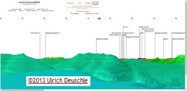 (148 KO) 1916 x 939 |
trace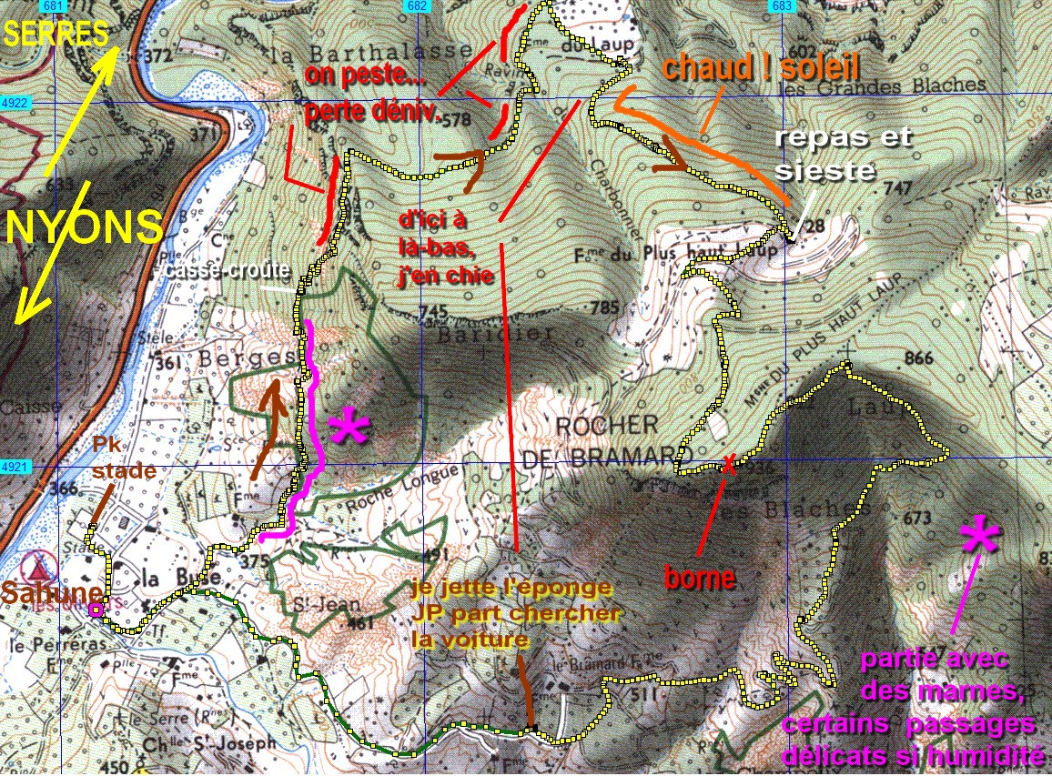 (630 KO) 1156 x 853 |
| |
|
| Copyright © 2019 par bnbd05 Tous droits réservés |
|
 _Guest book