Pic
Cascavelier – Saint Véran
(05) - -
- 21/10/12
________ ici
il n'y a que
les imagettes ,
si une ou plusieurs photos vous intéressent en
grand format ,
merci de me faire un mail
Pour
les noms
des sommets ,
on
peut dire qu'ils sont bons
à 90% ,
s'il y a erreur, à vous de corriger, au moins vous avez la
direction
!
Toute remarque constructive pour corriger les plus grosses
erreurs ici sera acceptée par bnbd05@yahoo.fr merci
Retour
Page Liste des Randos
* * * * * *
Attention
: d'abords un rappel
EN MONTAGNE, CHACUN
EST RESPONSABLE DE SA SÉCURITÉ .
Elle requiert également la conscience de ses propres capacités et de
ses limites propres, et implique par conséquent l'acceptation d'un
certain degré de risque.
Par conséquent, les randonnées se font
sous votre propre responsabilité. L'auteur de ce site ne peut pas
garantir l'exactitude ni l'exhaustivité des indications contenues dans
ce site.
Ces renseignements "gratuits" ne peuvent en aucun cas engager la
responsabilité de l'auteur.
* * * * * *
2 autres petits conseils :
que l'on veuille prendre des photos ou juste regarder :
on arrête d'abords
de marcher
dans un passage délicat, comme avec rochers, avec ou sans cables,
quand la marche avant n'est pas aisée ,
la marche
arrière peut être salutaire
*
* * * * *
*
* * * * *
* * * * * *
IMG_6941_rochebrune_1847.JPG
2592x1944 - 1852 ko
Grand Pic de Rochebrune
IMG_6942.JPG
2592x1944 - 1237 ko
IMG_6943.JPG
2592x1944 - 1266 ko
IMG_6944.JPG
2592x1944 - 1266 ko
IMG_6945_agrenier_1865.JPG
2592x1944 - 1837 ko l'Agrenier (
approche faite récemment )
IMG_6946_petit rochebrune_1983.JPG
2592x1944 - 1746 ko Petit
Rochebrune dans la brume
IMG_6947_au casse croute_2125.JPG
2592x1944 - 1928 ko on cherche la
Tête de Jacquette ......
IMG_6948.JPG
2592x1944 - 2031 ko mais, à priori,
elle est cachée
IMG_6949.JPG
2592x1944 - 1990 ko
IMG_6950.JPG
2592x1944 - 2169 ko
IMG_6951.JPG
2592x1944 - 2129 ko
IMG_6952.JPG
2592x1944 - 2263 ko
IMG_6953.JPG
2592x1944 - 2076 ko
IMG_6954.JPG
1944x2592 - 2089 ko
IMG_6955.JPG
1944x2592 - 2105 ko
IMG_6956_vers bergeries_2197.JPG
2592x1944 - 1924 ko
IMG_6957.JPG
2592x1944 - 2225 ko
IMG_6958.JPG
2592x1944 - 2131 ko
IMG_6959.JPG
2592x1944 - 2212 ko
IMG_6960.JPG
2592x1944 - 2338 ko
IMG_6962.JPG
2592x1944 - 2420 ko au bout, vers
l'ouest, on a les crêtes de la Rousse
IMG_6963.JPG
2592x1944 - 1912 ko
IMG_6964.JPG
2592x1944 - 2097 ko
IMG_6965_virage vers croix_2242.JPG
2592x1944 - 2638 ko on vient de
passer aux "bergeries"
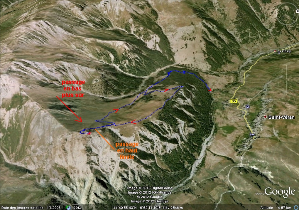
IMG_6966_croix de curlet_2281.JPG
2592x1944 - 2258 ko
IMG_6967.JPG
2592x1944 - 2198 ko Croix de Curlet
en vue
IMG_6968_a la croix_2300.JPG
2592x1944 - 2175 ko photos prises à
la croix
IMG_6969.JPG
2592x1944 - 2015 ko
IMG_6970.JPG
2592x1944 - 2080 ko St Véran
IMG_6971.JPG
2592x1944 - 2009 ko
IMG_6972.JPG
2592x1944 - 2023 ko
IMG_6973.JPG
2592x1944 - 2644 ko
IMG_6974.JPG
2592x1944 - 2599 ko
IMG_6975.JPG
2592x1944 - 2711 ko
IMG_6976.JPG
2592x1944 - 2488 ko
IMG_6977.JPG
2592x1944 - 2578 ko
IMG_6978.JPG
2592x1944 - 2578 ko
IMG_6979.JPG
2592x1944 - 2540 ko
IMG_6980.JPG
2592x1944 - 2510 ko
IMG_6981.JPG
2592x1944 - 2607 ko
IMG_6982.JPG
2592x1944 - 2692 ko
IMG_6983.JPG
2592x1944 - 2529 ko
IMG_6984.JPG
2592x1944 - 2217 ko
IMG_6985.JPG
2592x1944 - 2353 ko
IMG_6986.JPG
2592x1944 - 2368 ko
IMG_6987.JPG
2592x1944 - 2423 ko
IMG_6988.JPG
2592x1944 - 2336 ko
IMG_6990.JPG
2592x1944 - 1229 ko le resto où
Patrick nous a régalé
IMG_6991.JPG
2592x1944 - 2147 ko
IMG_6992.JPG
2592x1944 - 2077 ko
IMG_6993.JPG
2592x1944 - 1996 ko Sommet Bucher (
émetteur )
IMG_6994.JPG
2592x1944 - 1595 ko Gd Pelva au
flanc, au fond
IMG_6995.JPG
2592x1944 - 1516 ko
IMG_6996.JPG
2592x1944 - 1849 ko Pic de Château
Renard
IMG_6997.JPG
2592x1944 - 1955 ko
IMG_6998.JPG
2592x1944 - 2100 ko
IMG_6999.JPG
2592x1944 - 1972 ko
IMG_7000.JPG
2592x1944 - 1997 ko
IMG_7001_recherche de jacquette_2355.JPG
2592x1944 - 1924 ko
IMG_7002.JPG
2592x1944 - 1934 ko
IMG_7003.JPG
2592x1944 - 1883 ko
IMG_7004_fond de st veran_2387.JPG
2592x1944 - 2141 ko
IMG_7005.JPG
2592x1944 - 2189 ko
IMG_7006.JPG
2592x1944 - 2278 ko notre trace de
crête est magnifique
IMG_7007.JPG
2592x1944 - 909 ko
la Chapelle N-D de Closis
IMG_7008.JPG
2592x1944 - 1483 ko la Tête des
Toilies
IMG_7009.JPG
2592x1944 - 1449 ko Caramantran
IMG_7010.JPG
2592x1944 - 1452 ko les Sagnes
Longues, on verra mieux plus tard
IMG_7011.JPG
2592x1944 - 1521 ko l'observatoire
IMG_7012_on a pose les sacs_2537.JPG
2592x1944 - 2133 ko on a laissé les
sacs à Louis .....
IMG_7013.JPG
2592x1944 - 2170 ko ..... et
on prend le chemin du haut, limite
IMG_7014.JPG
2592x1944 - 1980 ko coup d'oeil
circulaire
IMG_7015.JPG
2592x1944 - 2305 ko
IMG_7016.JPG
2592x1944 - 2251 ko
IMG_7017.JPG
2592x1944 - 1741 ko l'arrivée est
là-haut
IMG_7018.JPG
2592x1944 - 2149 ko
IMG_7019.JPG
2592x1944 - 2398 ko vers le Pic des
Marcelettes .....
IMG_7020.JPG
2592x1944 - 2397 ko ..... où Louis
admire les chamois
IMG_7021.JPG
2592x1944 - 2096 ko
IMG_7022_carrefour a la montee_2553.JPG
2592x1944 - 2985 ko on arrive de
là .........
IMG_7023.JPG
2592x1944 - 2262 ko ......... et on
retrouve le chemin du bas
IMG_7024_jolies pierres_2566.JPG
2592x1944 - 2504 ko on y est presque
IMG_7025.JPG
2592x1944 - 2788 ko de bien belles
pierres
IMG_7026.JPG
2592x1944 - 1558 ko vers crête de
la Rousse à l'ouest
IMG_7027.JPG
2592x1944 - 2197 ko arrivée à la
crête et partie vers les Marcelettes
IMG_7028.JPG
2592x1944 - 2349 ko Marcelettes au
bout
IMG_7029_pic cascavelier_2578.JPG
2592x1944 - 2509 ko on est au Pic
Cascavelier
IMG_7030.JPG
2592x1944 - 2772 ko
IMG_7031.JPG
2592x1944 - 2960 ko
IMG_7032.JPG
2592x1944 - 2779 ko
IMG_7033.JPG
2592x1944 - 1935 ko
IMG_7034.JPG
2592x1944 - 1907 ko le Pic des
Marcelettes
IMG_7035.JPG
2592x1944 - 1497 ko coup d'oeil à
l'est vers Toilies etc
IMG_7036.JPG
2592x1944 - 1230 ko
IMG_7037.JPG
2592x1944 - 1210 ko
IMG_7038.JPG
2592x1944 - 1518 ko
IMG_7039.JPG
2592x1944 - 1571 ko
IMG_7040.JPG
2592x1944 - 1603 ko
IMG_7041.JPG
2592x1944 - 1504 ko
IMG_7042.JPG
2592x1944 - 819 ko
on le verra mieux tout-à-l'heure
IMG_7043.JPG
2592x1944 - 1509 ko
IMG_7044.JPG
2592x1944 - 1132 ko
IMG_7045.JPG
2592x1944 - 902 ko
l'observatoire .....
IMG_7046.JPG
2592x1944 - 925 ko
...... et son Pic
IMG_7047.JPG
2592x1944 - 831 ko
IMG_7048_carrefour au retour_2538.JPG
2592x1944 - 3333 ko on repart
manger ( carrefour ici )
IMG_7049_direction le repas_2518.JPG
1944x2592 - 2816 ko voilà, c'est
tout droit avec précaution
IMG_7050_recherche des chamois_2502.JPG
3072x2304 - 3040 ko
notre camarade nous compte combien de chamois il a vu là-haut, une
bonne vingtaine, dont un qui est venu dans notre vallon et qu'il a pu
admirer à loisir
IMG_7051.JPG
3072x2304 - 3062 ko je les cherche
.....
IMG_7052.JPG
3072x2304 - 2021 ko .... et
mitraille un peu au hasard
IMG_7053.JPG
3072x2304 - 1650 ko
IMG_7054.JPG
3072x2304 - 1614 ko
IMG_7055.JPG
3072x2304 - 1713 ko
IMG_7056.JPG
3072x2304 - 1487 ko
IMG_7057.JPG
3072x2304 - 1742 ko
IMG_7058.JPG
2592x1944 - 1326 ko
IMG_7059.JPG
2592x1944 - 1347 ko le Pic
Cascavelier est éblouissant
IMG_7060_mont viso_2502.JPG
2592x1944 - 883 ko
IMG_7061.JPG
2592x1944 - 859 ko
IMG_7062_les chamois_2502.JPG
2592x1944 - 1837 ko
IMG_7063.JPG
2592x1944 - 1971 ko
IMG_7064.JPG
2592x1944 - 2095 ko .... les voilà,
là haut à la crête, au centre
IMG_7065.JPG
2592x1944 - 987 ko
IMG_7066.JPG
2592x1944 - 883 ko
IMG_7068.JPG
2592x1944 - 984 ko
IMG_7069.JPG
2592x1944 - 1050 ko
IMG_7070.JPG
2592x1944 - 1165 ko
IMG_7071.JPG
2592x1944 - 1112 ko
IMG_7072_viso embrume_2502.JPG
2592x1944 - 1529 ko
IMG_7073.JPG
2592x1944 - 854 ko
IMG_7074_st veran_2502.JPG
2592x1944 - 1640 ko le Viso un peu
mieux
IMG_7075.JPG
2592x1944 - 2235 ko
IMG_7076.JPG
2592x1944 - 2230 ko
IMG_7077.JPG
2592x1944 - 959 ko
la demoiselle coiffée, en haut
IMG_7078_beau rocher_2490.JPG
1944x2592 - 2522 ko
IMG_7079.JPG
1944x2592 - 2278 ko on attaque la
descente dans le vallon par une trace bien nette qui va rejoindre la
trace du vallon
IMG_7080_toilies etc_2464.JPG
2592x1944 - 1604 ko là on est à
l'ouest
IMG_7081.JPG
2592x1944 - 943 ko
IMG_7082.JPG
2592x1944 - 1809 ko la Tête des
Toilies
IMG_7083.JPG
2592x1944 - 1717 ko Caramantran
IMG_7084.JPG
2592x1944 - 1591 ko
IMG_7085.JPG
2592x1944 - 1589 ko Pain de Sucre
peut-être à l'arrière
IMG_7086.JPG
2592x1944 - 1583 ko les Sagnes
Longues
IMG_7087.JPG
2592x1944 - 1616 ko
IMG_7088.JPG
2592x1944 - 1580 ko au pied de
Rochebrune
IMG_7089.JPG
2592x1944 - 1147 ko Toilies
IMG_7090.JPG
2592x1944 - 1301 ko
IMG_7091_coup d oeil arriere_2421.JPG
2592x1944 - 2116 ko visu de la zone
du pic vue du vallon
IMG_7092.JPG
2592x1944 - 2065 ko
IMG_7093.JPG
2592x1944 - 1783 ko
IMG_7094.JPG
2592x1944 - 1700 ko
IMG_7095.JPG
2592x1944 - 1523 ko
IMG_7096.JPG
2592x1944 - 3057 ko c'est tout droit
IMG_7097_fond du vallon_2357.JPG
2592x1944 - 2247 ko
IMG_7098.JPG
2592x1944 - 2557 ko
IMG_7099.JPG
2592x1944 - 2378 ko
IMG_7100.JPG
2592x1944 - 2406 ko
IMG_7101.JPG
2592x1944 - 1203 ko
IMG_7102.JPG
2592x1944 - 1241 ko
IMG_7103_sieste_2225.JPG
2592x1944 - 2355 ko avant qu'il ne
pleuve, faisons la sieste
IMG_7104.JPG
2592x1944 - 1838 ko
IMG_7105.JPG
2592x1944 - 1590 ko
IMG_7106_melezes1_2220.JPG
2592x1944 - 2230 ko il n'a pas plu,
on admire les couleurs de l'automne ...
IMG_7107_melezes2_2130.JPG
1944x2592 - 2021 ko
IMG_7108_melezes3_2008.JPG
2592x1944 - 2624 ko
IMG_7109_chalets_1944.JPG
2592x1944 - 2528 ko ...
et les chalets
IMG_7110_agrenier_1883.JPG
2592x1944 - 1449 ko l'ancien poste
optique au pied de l'Agrenier
IMG_7111.JPG
2592x1944 - 1613 ko et la crête du
col de crèche sous Rochebrune
Page générée le 22/10/2012 Retour
compteur de visite html
website tracker widget
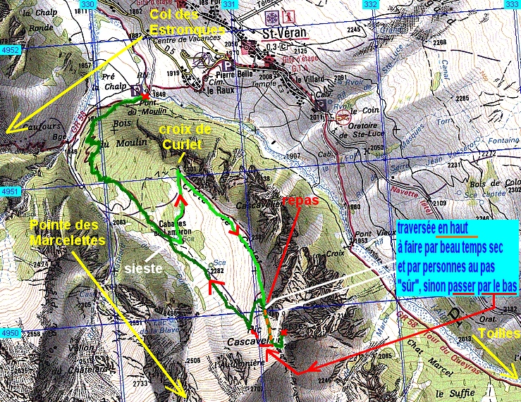