| Pointe feuillette ( les Amayères ) aller - retour via le col de Chausseyras 01/11/2017 |
bien lire les infos traces à la fin de page, exploitation forestière en cours, trace menacée dans les mois à venir ? |
| - Canon PS A710 (200x) | |
IMG_8844_08h16.JPG (2.04 MO) 3072 x 2304 |
IMG_8845.JPG (3.42 MO) 3072 x 2304 un oeil vers le Chevalet ( fait ) |
IMG_8846.JPG (2.14 MO) 3072 x 2304 nous montons donc par le Col de Chausseyras, en obliquant à droite, avec un balisage "jaune-vert" ... pistes puis chemin pentus mais de très bonne qualité, voie non testée en 2014, prévue au retour, mais ratée, suite à un balisage vieillot ou absent ! Toutes indications, panneaux, traces et photos à la fin de cette page, à partir de la photo 8993 |
IMG_8847_09h39.JPG (3.7 MO) 2304 x 3072 voici le panneau au col qui n'indique toujours pas le retour aux Amayères à 90° à d, dans petit vallon ( cf 8990 ) |
IMG_8848.JPG (4.92 MO) 2304 x 3072 |
IMG_8849.JPG (4 MO) 3072 x 2304 voilà, pour le retour aux Amayères, se diriger vers le Chevalet, et la trace va se préciser en avançant, en arc de cercle vers la g. |
IMG_8850.JPG (4.26 MO) 3072 x 2304 petit coup d'oeil circulaire au col |
IMG_8851.JPG (4.26 MO) 3072 x 2304 |
IMG_8852.JPG (4.76 MO) 3072 x 2304 on va continuer là, trace évidente |
IMG_8853.JPG (4.49 MO) 3072 x 2304 |
IMG_8854.JPG (3.59 MO) 3072 x 2304 |
IMG_8855.JPG (3.37 MO) 3072 x 2304 |
IMG_8856.JPG (3.38 MO) 3072 x 2304 |
IMG_8857.JPG (3.31 MO) 3072 x 2304 |
IMG_8858.JPG (3.06 MO) 3072 x 2304 Garnesier au centre |
IMG_8859.JPG (2.89 MO) 3072 x 2304 |
IMG_8860.JPG (2.26 MO) 3072 x 2304 là le Pic de l'Aigle, sans doute |
IMG_8861.JPG (2.01 MO) 3072 x 2304 |
IMG_8862.JPG (2.07 MO) 3072 x 2304 |
IMG_8863.JPG (2.04 MO) 3072 x 2304 |
IMG_8864.JPG (1.99 MO) 3072 x 2304 la Tête de Vachères |
IMG_8865.JPG (2.61 MO) 3072 x 2304 celui au centre d. serait le Rocher Rond ( 2463m ) |
IMG_8866.JPG (2.35 MO) 3072 x 2304 |
IMG_8867.JPG (2.56 MO) 3072 x 2304 |
IMG_8868.JPG (3.2 MO) 3072 x 2304 le Jocou |
IMG_8869.JPG (3.45 MO) 3072 x 2304 le Chevalet, assez facile à faire et beau 360° |
IMG_8870.JPG (2.61 MO) 3072 x 2304 |
IMG_8871.JPG (2.6 MO) 3072 x 2304 |
IMG_8872.JPG (2.65 MO) 3072 x 2304 |
IMG_8873_09h48.JPG (4.14 MO) 3072 x 2304 |
IMG_8874.JPG (4.26 MO) 3072 x 2304 on peut voir que JP est déjà passé là jadis |
IMG_8875_10h07.JPG (3.66 MO) 3072 x 2304 en cours de montée ( #1677m ) |
IMG_8876.JPG (3.49 MO) 3072 x 2304 |
IMG_8877.JPG (3.26 MO) 3072 x 2304 |
IMG_8878.JPG (3.15 MO) 3072 x 2304 |
IMG_8879.JPG (2.87 MO) 3072 x 2304 |
IMG_8880.JPG (2.62 MO) 3072 x 2304 Piégros au 1er plan |
IMG_8881.JPG (2.39 MO) 3072 x 2304 |
IMG_8882.JPG (2.06 MO) 3072 x 2304 |
IMG_8883.JPG (1.97 MO) 3072 x 2304 |
IMG_8884.JPG (2.23 MO) 3072 x 2304 |
IMG_8885.JPG (2.51 MO) 3072 x 2304 |
IMG_8886.JPG (3.42 MO) 3072 x 2304 |
IMG_8887.JPG (4.03 MO) 3072 x 2304 il reste du chemin... |
IMG_8888.JPG (2.19 MO) 3072 x 2304 |
IMG_8889.JPG (2.02 MO) 3072 x 2304 |
IMG_8890.JPG (2.05 MO) 3072 x 2304 |
IMG_8891.JPG (2.44 MO) 3072 x 2304 |
IMG_8892.JPG (2.15 MO) 3072 x 2304 |
IMG_8893.JPG (3.12 MO) 3072 x 2304 |
IMG_8894.JPG (2.93 MO) 3072 x 2304 |
IMG_8895.JPG (2.41 MO) 3072 x 2304 |
IMG_8896.JPG (2.42 MO) 3072 x 2304 |
IMG_8897.JPG (2.4 MO) 3072 x 2304 |
IMG_8898.JPG (2.29 MO) 3072 x 2304 |
IMG_8899_10h11.JPG (2.45 MO) 3072 x 2304 un peu plus haut, en progression... (#1699m) |
IMG_8900.JPG (2.72 MO) 3072 x 2304 |
IMG_8901.JPG (2.58 MO) 3072 x 2304 |
IMG_8902.JPG (2.68 MO) 3072 x 2304 |
IMG_8903.JPG (4.01 MO) 3072 x 2304 voilà le bilan ... |
IMG_8904.JPG (2.34 MO) 3072 x 2304 |
IMG_8905_10h23.JPG (2.72 MO) 3072 x 2304 en cours toujours ! ( #1765m ) |
IMG_8906.JPG (2.58 MO) 3072 x 2304 |
IMG_8907.JPG (2.98 MO) 3072 x 2304 |
IMG_8908.JPG (2.43 MO) 3072 x 2304 |
IMG_8909.JPG (2.1 MO) 3072 x 2304 |
IMG_8910_10h37.JPG (4.07 MO) 3072 x 2304 ( #1816m ) encore un petit effort ... |
IMG_8911.JPG (4.02 MO) 3072 x 2304 on vois bien la trace sur le premier plateau |
IMG_8912.JPG (4.38 MO) 3072 x 2304 tout ceci vu juste avant le dernier replat |
IMG_8913_10h56.JPG (3.86 MO) 3072 x 2304 on est au but !!! |
IMG_8914.JPG (3.63 MO) 3072 x 2304 tout de suite un premier 360 sens horaire sans zoom jusqu'à ---> 8933 |
IMG_8915.JPG (2.98 MO) 3072 x 2304 |
IMG_8916.JPG (2.83 MO) 3072 x 2304 |
IMG_8917.JPG (2.86 MO) 3072 x 2304 |
IMG_8918.JPG (2.96 MO) 3072 x 2304 |
IMG_8919.JPG (3.12 MO) 3072 x 2304 |
IMG_8920.JPG (3.31 MO) 3072 x 2304 |
IMG_8921.JPG (3.19 MO) 3072 x 2304 |
IMG_8922.JPG (3.24 MO) 3072 x 2304 |
IMG_8923.JPG (3.28 MO) 3072 x 2304 |
IMG_8924.JPG (3.31 MO) 3072 x 2304 |
IMG_8925.JPG (3.41 MO) 3072 x 2304 |
IMG_8926.JPG (3.15 MO) 3072 x 2304 |
IMG_8927.JPG (2.7 MO) 3072 x 2304 |
IMG_8928.JPG (2.2 MO) 3072 x 2304 |
IMG_8929.JPG (2.44 MO) 3072 x 2304 |
IMG_8930.JPG (2.26 MO) 3072 x 2304 |
IMG_8931.JPG (2.99 MO) 3072 x 2304 |
IMG_8932.JPG (2.98 MO) 3072 x 2304 |
IMG_8933.JPG (3.19 MO) 3072 x 2304 ---> fin du premier 360 |
IMG_8934.JPG (2.08 MO) 3072 x 2304 la Tête de Vachères |
IMG_8935.JPG (4.25 MO) 3072 x 2304 la suite qui vire à g. vers le col de Jajène ( peu après notre arrivée, arrivera "el phénomèno" par cette voie ) |
IMG_8936.JPG (4.42 MO) 3072 x 2304 |
IMG_8937.JPG (3.97 MO) 3072 x 2304 |
IMG_8938.JPG (3.74 MO) 3072 x 2304 |
IMG_8939.JPG (3.27 MO) 3072 x 2304 le chemin du col de Jajène continue dans cet axe |
IMG_8940.JPG (2.99 MO) 3072 x 2304 |
IMG_8941.JPG (2.9 MO) 3072 x 2304 et nous, en 2014, on a dû manger là au centre après avoir longé la congère de neige accrochée aux rochers |
IMG_8942.JPG (3.52 MO) 3072 x 2304 |
IMG_8943.JPG (3.38 MO) 3072 x 2304 |
IMG_8944.JPG (3.6 MO) 3072 x 2304 |
IMG_8945_11h00.JPG (2.43 MO) 3072 x 2304 un coup d'oeil sur le Grand Serre etc |
IMG_8946.JPG (2.45 MO) 3072 x 2304 |
IMG_8947.JPG (2.43 MO) 3072 x 2304 Bonnet de Calvin au centre |
IMG_8948.JPG (2.58 MO) 3072 x 2304 |
IMG_8949.JPG (2.35 MO) 3072 x 2304 Aiguille, Ratier et Obiou |
IMG_8950.JPG (2.24 MO) 3072 x 2304 Sénépy et La Pérouse vers La Mure faits jadis |
IMG_8951.JPG (2.54 MO) 3072 x 2304 |
IMG_8952.JPG (2.34 MO) 3072 x 2304 le Mont Barral que l'on fera peut-être un jour ? |
IMG_8953_11h03.JPG (1.94 MO) 3072 x 2304 les Chamoussets et Durbonnas à l'arrière |
IMG_8954_11h05.JPG (2.44 MO) 3072 x 2304 la chaîne du Vercors en détails --> |
IMG_8955.JPG (2.42 MO) 3072 x 2304 |
IMG_8956.JPG (2.6 MO) 3072 x 2304 |
IMG_8957.JPG (2.61 MO) 3072 x 2304 Mt Aiguille et Gd Veymont groupés |
IMG_8958.JPG (2.4 MO) 3072 x 2304 |
IMG_8959.JPG (2.25 MO) 3072 x 2304 |
IMG_8960.JPG (2.25 MO) 3072 x 2304 |
IMG_8961.JPG (2.29 MO) 3072 x 2304 |
IMG_8962.JPG (2.4 MO) 3072 x 2304 |
IMG_8963.JPG (2.55 MO) 3072 x 2304 |
IMG_8964.JPG (2.67 MO) 3072 x 2304 |
IMG_8965.JPG (2.58 MO) 3072 x 2304 les Moucherolles et les deux Soeurs au c. |
IMG_8966.JPG (2.48 MO) 3072 x 2304 |
IMG_8967.JPG (2.48 MO) 3072 x 2304 le Cornafion doit être au c. d. |
IMG_8968.JPG (2.55 MO) 3072 x 2304 le Pic St Michel au c. |
IMG_8969.JPG (2.49 MO) 3072 x 2304 ---> nous voici au bout, au Moucherotte à d. |
IMG_8970.JPG (2.16 MO) 3072 x 2304 on devine à peine la Chartreuse dans la brume OU la pollution de Grenoble ( ou les deux ) |
IMG_8971.JPG (2.26 MO) 3072 x 2304 la Dent de Crolles au c. embrumée |
IMG_8972_13h20.JPG @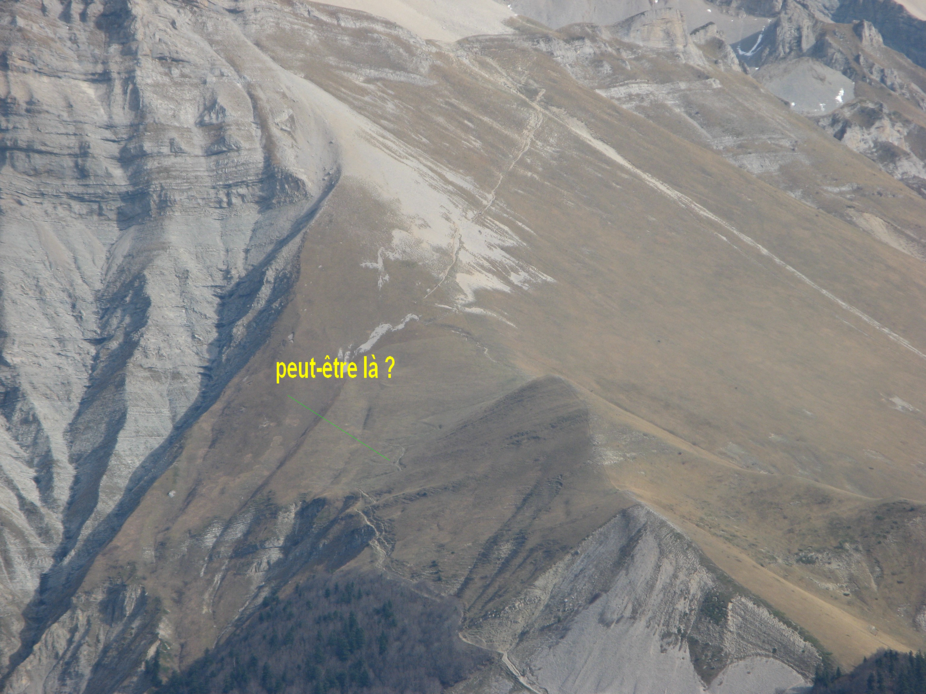 (2.99 MO) 3072 x 2304 là, je voulais prendre la progression de "el phénomèno", mais je ne le retrouve pas ! ( re-parti par la montagne de Paille vers le col de la Croix ) On eut aimé discuter davantage avec lui mais il était pressé ! |
IMG_8973.JPG (1.39 MO) 3072 x 2304 nous avons nommé ainsi un brave monsieur ( Gapençais natif de 1949 ) qui est arrivé par le col de Jajène, indécis pour la suite, à décidé de se diriger vers le lac du Lauzon pour y bivouaquer... re- bonjour monsieur si vous passez ici, félicitations pour votre allure de fantassin ! |
IMG_8974_14h20.JPG (2.47 MO) 3072 x 2304 après le repas et la sieste, les éclairages ayant évolué... |
IMG_8975.JPG (2.47 MO) 3072 x 2304 le Rognon au plan médian |
IMG_8976.JPG (2.38 MO) 3072 x 2304 |
IMG_8977.JPG (2.49 MO) 3072 x 2304 |
IMG_8978.JPG (2.76 MO) 3072 x 2304 |
IMG_8979.JPG (2.85 MO) 3072 x 2304 |
IMG_8980.JPG (2.96 MO) 3072 x 2304 |
IMG_8981.JPG (2.74 MO) 3072 x 2304 |
IMG_8982.JPG (2.51 MO) 3072 x 2304 |
IMG_8983.JPG (2.56 MO) 3072 x 2304 on voit un peu mieux les Tabor et Taillefers |
IMG_8984.JPG (2.39 MO) 3072 x 2304 |
IMG_8985.JPG (2.79 MO) 3072 x 2304 |
IMG_8986.JPG (2.96 MO) 3072 x 2304 Tête de Lauzon au c. g., avant descente |
IMG_8988_14h31.JPG (2.76 MO) 3072 x 2304 pendant la descente, une curieuse ligne jaune |
IMG_8989_14h40.JPG (2.33 MO) 3072 x 2304 |
IMG_8990_14h54.JPG (4.39 MO) 3072 x 2304 |
IMG_8991_14h58.JPG (3.25 MO) 3072 x 2304 |
IMG_8992.JPG (2.96 MO) 3072 x 2304 une autre vue de la ligne jaune, puis on repart |
IMG_8993_15h10.JPG (5.36 MO) 3072 x 2304 à 12mn du col, ici commencent les marques vitales |
IMG_8994.JPG (5.21 MO) 3072 x 2304 |
IMG_8995.JPG (5.25 MO) 3072 x 2304 |
IMG_8996.JPG (5.57 MO) 3072 x 2304 |
IMG_8997.JPG (5.53 MO) 3072 x 2304 |
IMG_8998.JPG (5.21 MO) 2304 x 3072 balisage ici peu utile dans ce sens, pour le moins |
IMG_8999_15h25.JPG (5.33 MO) 3072 x 2304 chemin à d. que l'on vient de quitter |
IMG_9000.JPG (5.33 MO) 3072 x 2304 à l'aller, quitter la piste qui,elle, continue à g. |
IMG_9001_15h29.JPG (5.14 MO) 3072 x 2304 balisage juste après bifurcation 9003, sens aller |
IMG_9002_15h31.JPG (5.07 MO) 3072 x 2304 les 2 tourne... |
IMG_9003.JPG (4.77 MO) 3072 x 2304 bifurcation, à l'aller, à d. ( sur arbre à g. de cette photo, les tourne de 9002 ) |
IMG_9004.JPG (4.58 MO) 3072 x 2304 là, à l'aller, on va à g. ... la bifurcation suit de peu |
IMG_9005.JPG (2.67 MO) 3072 x 2304 |
IMG_9006_15h50.JPG (2.9 MO) 2304 x 3072 |
IMG_9007.JPG (2.84 MO) 3072 x 2304 nous on est partis par cette voie |
IMG_9008.JPG (3.05 MO) 3072 x 2304 on a ignoré celle-ci |
IMG_9009.JPG (4.19 MO) 3072 x 2304 |
trace @ 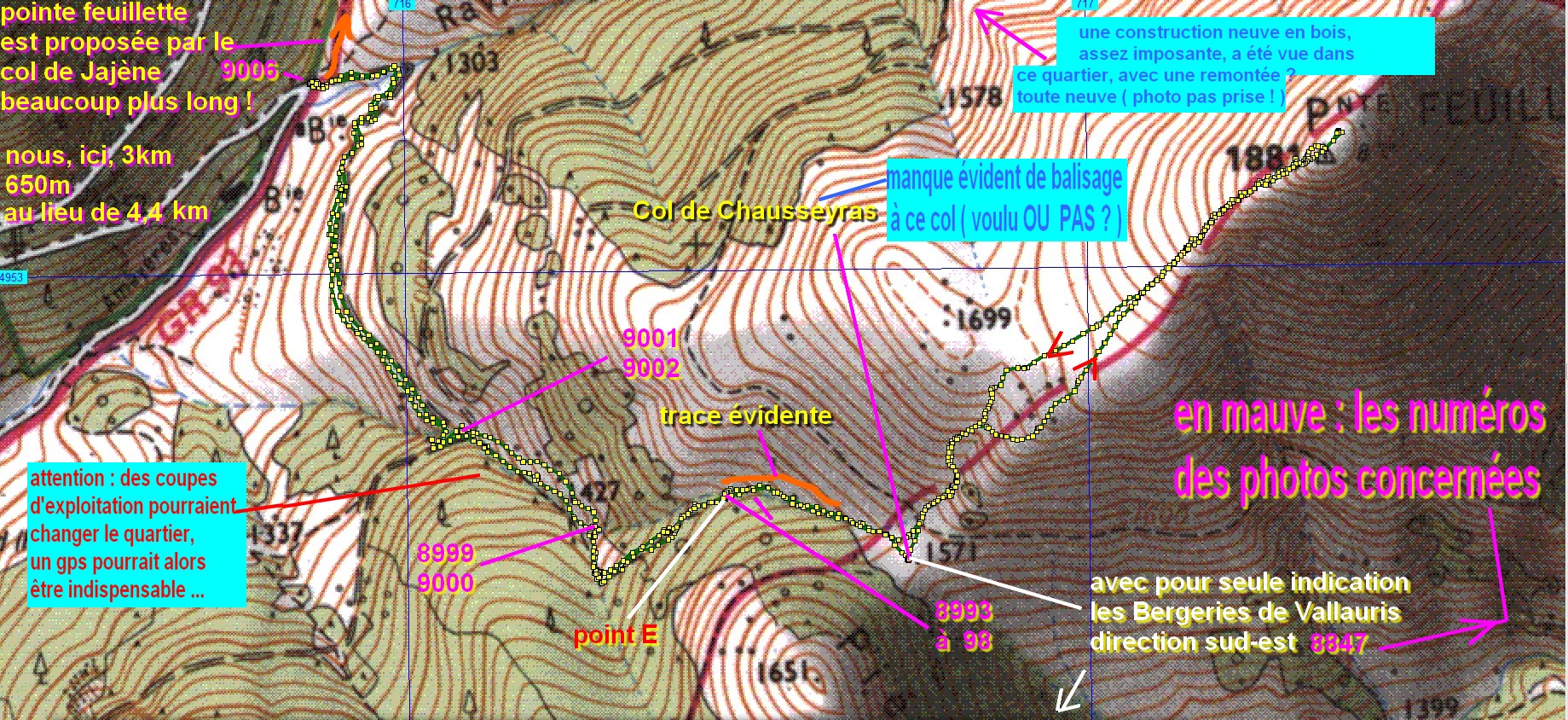 (818 KO) 1839 x 844 le défaut de balisage, présumé absent en 2014 ( au moins en partie ), est confirmé |
| rappel de l'erreur de 2014 @ 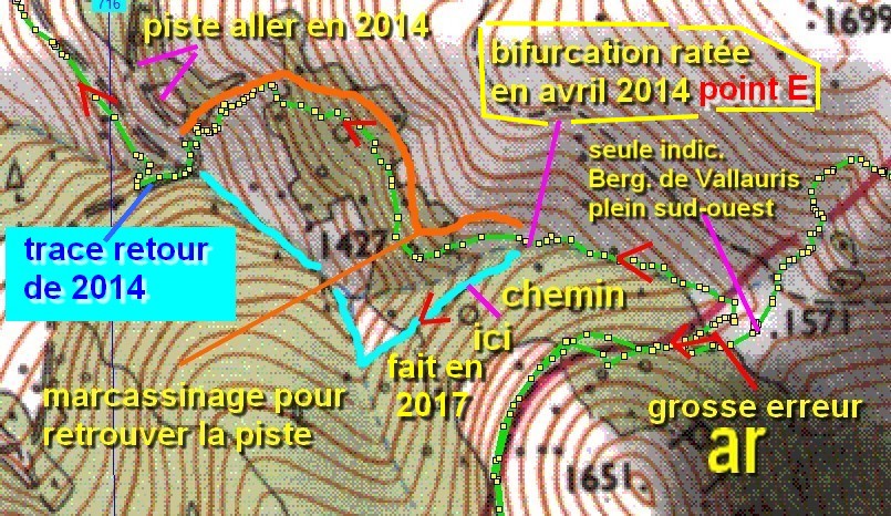 (211 KO) 805 x 466 | pano virtuel sur 360° @ 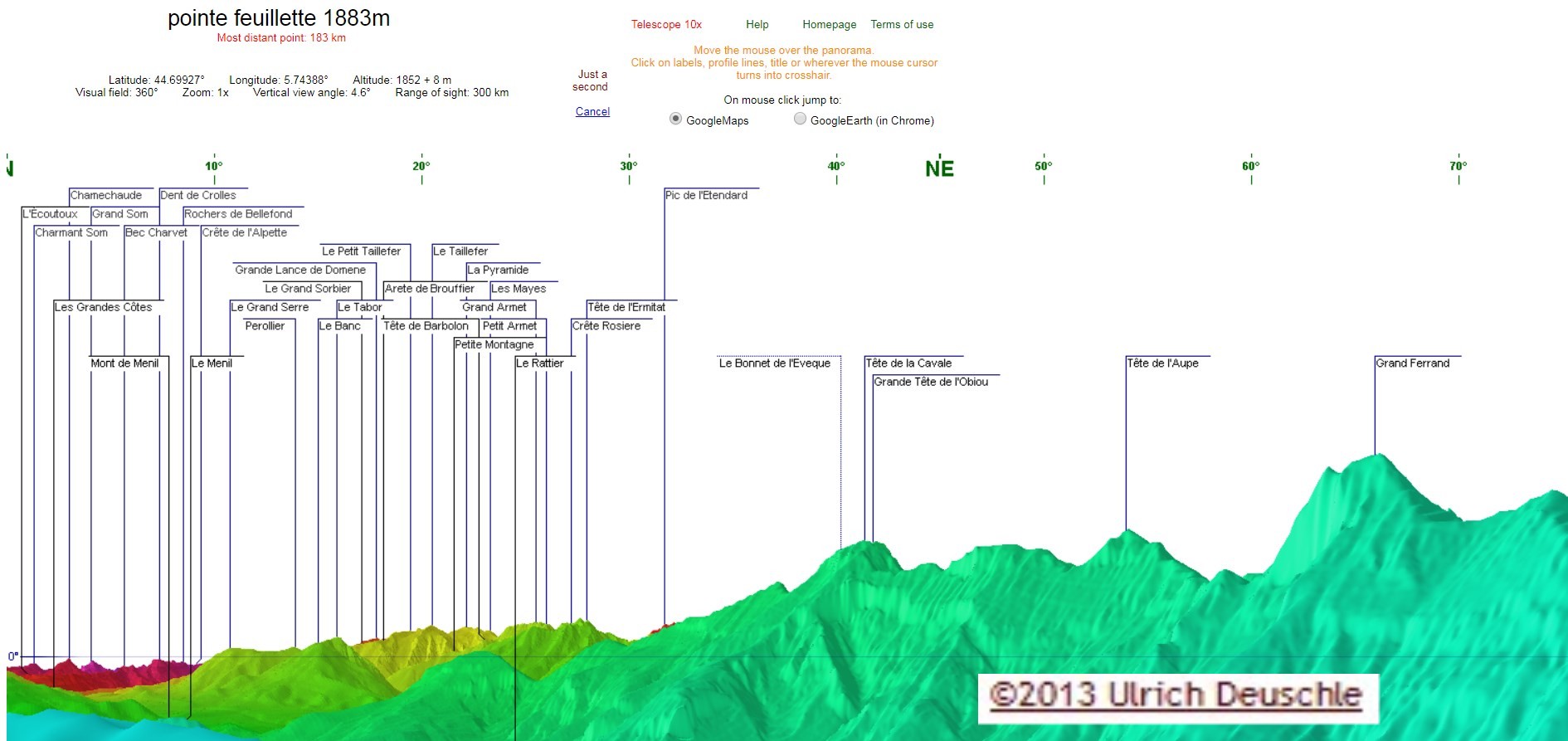 |
|
|
|
 _Guest book